25th Annual Black Diamond Fall Fundraising Party
Thursday, September 13; 6:00-10:00 PM; Black Diamond Parking Lot
25th Annual Black Diamond Fall Fundraising Party
Thursday, September 13; 6:00-10:00 PM; Black Diamond Parking Lot
| Advisory: Salt Lake Area Mountains | Issued by Evelyn Lees for Saturday - December 9, 2017 - 5:50am |
|---|

|
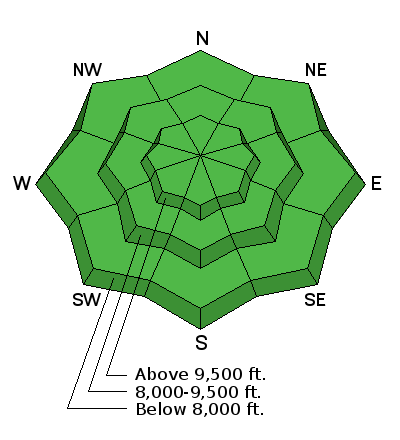
bottom line The avalanche danger is LOW – but small avalanches can be triggered in isolated areas or extreme terrain, most likely on an upper elevation slope facing northwest through northeast. Small wind slabs, shallow sluffs or a small slide breaking a foot deep into older snow are possible, though unlikely, on steep slopes. Any ride will likely involve hitting damaging rocks or stumps. The snow pack is very shallow - riding on lower angle, grassy slopes will reduce the number of rocks and stumps you will hit.
|
 |
special announcement
Get important updates from the UAC via text message directly to your phone. Its very simple - text 40404 and send this message "Follow uacwasatch". Looking for a great stocking stuffer for Christmas? Discount lift tickets for Alta, Snowbird, Brighton, Solitude, Deer Valley, Snowbasin,and Beaver Mountain are now available, donated by the resorts to benefit the Utah Avalanche Center. Details and order information here. These make a great holiday gift and all proceeds go towards paying for avalanche forecasting and education! Support the UAC when you shop Whole Foods Market at Trolley Square, Sugarhouse, and Cottonwood Heights. Between now and Jan 11th, Whole Foods will donate a dime per bag to Utah Avalanche Center when you shop there and donate your bag credit during check out. Please abide by the uphill travel policies of the ski resorts. Info here. |
 |
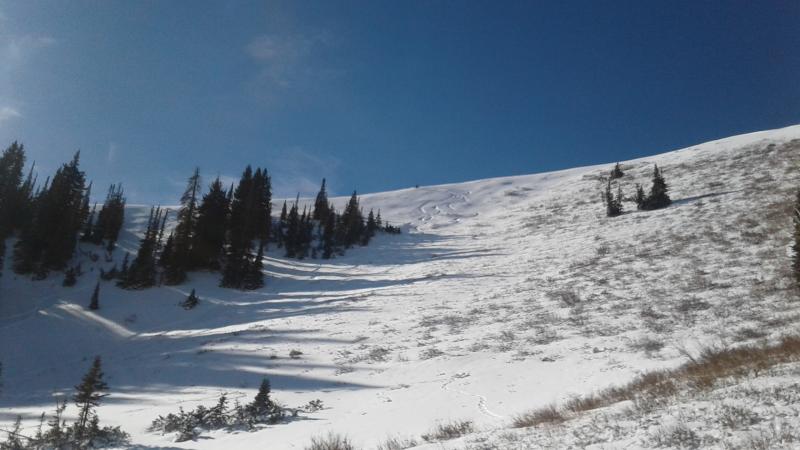
current conditions It's a beautiful day to head to the mountains, with clear skies, warming tempearatures and light northwesterly winds, in the 5 to 10 mph range. Even across the highest peaks, wind speeds are only averaging 15 to 20 mph. Temperatures are marching upward, already in the mid to low 30s as of 6 am. Cold air is still pooled in the canyon bottoms, where temperatures are still clinging to teens. Total snow on the ground at the upper elevations is around 2 feet. And with that the only game in town, people are finding it’s enough to get out and carefully recreate, though hitting rocks and stumps is almost a given. Soft snow is getting harder to find – now mixed in with sun crusts and wind crusts. By choosing low angle, grassy slopes and traveling on snow packed roads and trails, you can reduce the number of rocks you will hit. If you’re on a sled, it'd be wise to stick to the roads and not chance banging up your machine. Snowshoeing is a great option for the shallow snow conditions. But shallow is shallow. J Rowell photo. Full observations HERE.
With limited terrain available for riding (low tide as some call it), take the time to practice with your rescue gear if you get out. Watch this video. Matt and Tom were glad they had practiced and luckily had a happy ending. |
 |
recent activity The last avalanche reported was Thursday, when Gazex testing released a small slide on an upper elevation, northwesterly facing slope, which gouged into the weak snow as it ran downhill. |
| type | aspect/elevation | characteristics |
|---|

|
|
LIKELIHOOD
 LIKELY
UNLIKELY
SIZE
 LARGE
SMALL
TREND
 INCREASING DANGER
SAME
DECREASING DANGER
|
|
description
LOW danger doesn’t mean NO danger. Small avalanches can still be triggered in isolated places or radical terrain. The most likely place to trigger any of these slides would be on a steep, upper elevation northwest through northeasterly facing slope. Wind drifts – several days of stronger, northeasterly winds this week left behind hard, shallow wind drifts, mostly at the higher elevations and along ridge lines. Avoid travel on these hard, shallow, cracky wind drifts, which are cross-loaded onto a variety of aspects. Persistent weak layers – the snowpack consists of weak crusts and sugary faceted layers on the shady mid and upper elevation slopes. These are the number one concern for the future. But until we get additional weight from new snow on top, these layers are mostly dormant. It’s eye opening to quickly dig a pit and check out what really weak snow looks like. Loose Snow Sluffs – as the snow surface facets and weakens, watch out for triggering shallow, loose snow sluffs on steep slopes. |
 |
weather The high pressure over Utah isn’t budging, so a series of copycat days is on the way, with sunny skies and warm temperatures in the mountains through midweek and beyond. Temperatures each day will warm into the upper 30s to mid 40s, with the overnight low dipping into 20s. The northerly winds will average 5 to 15 mph, with the highest peaks averaging 20 to 25 mph. |
general announcements
|