25th Annual Black Diamond Fall Fundraising Party
Thursday, September 13; 6:00-10:00 PM; Black Diamond Parking Lot
25th Annual Black Diamond Fall Fundraising Party
Thursday, September 13; 6:00-10:00 PM; Black Diamond Parking Lot
| Advisory: Salt Lake Area Mountains | Issued by Drew Hardesty for Monday - December 4, 2017 - 6:05am |
|---|


|
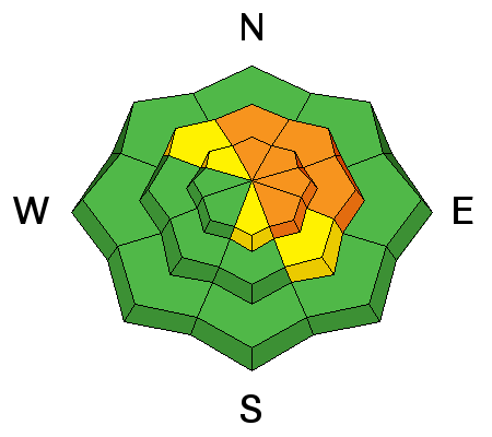
bottom line A CONSIDERABLE danger exists for natural and human triggered avalanches in steep terrain. Wind drifts and loose snow avalanches should be expected in all steep terrain holding previous snow (mid and upper elevation northwest through east facing slopes). Shooting cracks and audible collapsing of the snowpack are immediate signs of potential avalanche danger. Hot Tip: the best conditions will also be the safest: lower angle non-drifted terrain will be 5 star with the cold smoke on the underlying crusts.
|
 |
special announcement Support the UAC when you shop Whole Foods Market at Trolley Square, Sugarhouse, and Cottonwood Heights. Between now and Jan 11th, Whole Foods will donate a dime per bag to Utah Avalanche Center when you shop there and donate your bag credit during check out. There are still spots left for the FREE Avalanche Awareness for Women evening talk on Tuesday, December 5th, presented by REI, SheJumps and the Utah Avalanche Center. Sign up for free with REI HERE. Please abide by the uphill travel policies of the ski resorts. Info here. |
 |
current conditions A good old fashioned cold front crashed through the Wasatch last night and snow totals are up to a foot (12"/0.86"SWE) in the Cottonwoods and the northern end of the Park City ridgeline. It's still snowing. The Ogden area mountains have 8" thus far; the Provo mountains 2-4". Drive north: the Logan area mountains are reporting up to 2' of new snow. Mountain temps crashed to the single digits up high, the mid-teens down low. Winds along the ridgelines blow 15-20mph with gusts to 35. The highest elevation anemometers have winds blowing 35-40mph with gusts to 50+. Total snow depths are just now cresting 2' in the upper elevations while the bare ground on the sunny aspects is now painted white. |
 |
recent activity Loose snow sluffs have already been reported running naturally on the road cuts this morning. |
| type | aspect/elevation | characteristics |
|---|

|
|
LIKELIHOOD
 LIKELY
UNLIKELY
SIZE
 LARGE
SMALL
TREND
 INCREASING DANGER
SAME
DECREASING DANGER
|
|
description
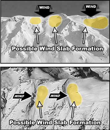
Very soft wind drifts approaching two feet deep will be commonplace along the lee of ridgelines and cross-loaded into gullies and couloirs. Shooting cracks will be key indicators of instability in the wind drifted terrain. Look for them around terrain features and rocky outcrops and any deceleration zones. Note that the winds can deposit this low density snow in unusual areas.
|
| type | aspect/elevation | characteristics |
|---|

|

|
LIKELIHOOD
 LIKELY
UNLIKELY
SIZE
LARGE
SMALL
TREND
INCREASING DANGER
SAME
DECREASING DANGER
|
|
description
The new snow will bond poorly to the old slick crusts at the mid and upper elevations and likely tend to run fast and far in steep, sustained terrain. (I'd expect decent debris piles, particularly in steep-walled terrain traps.) Naturally running sluffs will continue to be likely today with additional snowfall. It's key to remember that, prior to the storm, only northwest through some east facing slopes held snow. On the sunny aspects, the new snow is landing on dirt, bare ground, rocks, and bushes. |
| type | aspect/elevation | characteristics |
|---|

|
|
LIKELIHOOD
 LIKELY
UNLIKELY
SIZE
LARGE
SMALL
TREND
 INCREASING DANGER
SAME
DECREASING DANGER
|
|
description
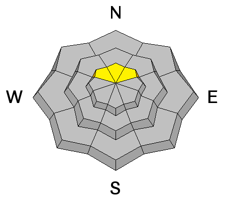
Two-months-worth of old weak sugary snow is capped and protected by a thin rain/rime crust ranging from a few a few millimeters to a couple centimeters thick. We may be approaching enough snow and wind-drifted-snow to collapse the crust in isolated areas in the high northerly terrain. Where this is the case, audible collapsing of this crust often accompanies these persistent slab avalanches and these then may be triggered from adjacent slopes, or from below.
|
 |
weather Get it while you can. We should be able to squeeze a few more inches of low density snow out of the storm before it moves off to the east. Winds as well should start to calm down and blow 15mph from the northwest. Temps will be in the upper single digits along the high ridglines and the teens at the trailheads. What has been already billed as a "monster ridge" starts to build in tomorrow for the foreseeable future. |
general announcements
|