25th Annual Black Diamond Fall Fundraising Party
Thursday, September 13; 6:00-10:00 PM; Black Diamond Parking Lot
25th Annual Black Diamond Fall Fundraising Party
Thursday, September 13; 6:00-10:00 PM; Black Diamond Parking Lot
| Advisory: Salt Lake Area Mountains | Issued by Mark Staples for Friday - December 1, 2017 - 7:13am |
|---|

|
bottom line Avalanche conditions are generally safe and the danger is LOW. We will continue with intermittent advisories until we begin to receive more snow.
|
 |
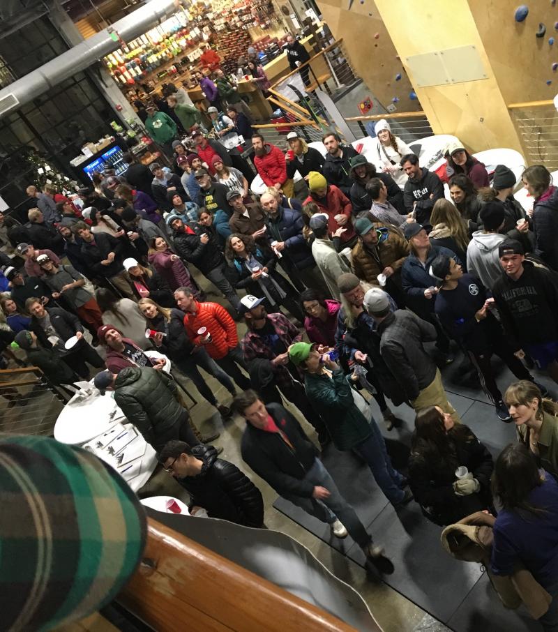
special announcement Last night's first annual Ogden Backcountry Bash at The Front Climbing Gym was a GIANT SUCCESS! Thank you to everyone that came to support the Utah Avalanche Center and it's mission to keep everyone on top. A big shout out to all the businesses that made donations, volunteers that helped setup, as well as Lucky Slice for the delicious pizza and Talisman Brewery and Ogden's Own for the beverages. We appreciate all the support and look forward to making this an annual event. Lastly, we want to say a massive thank you to Kory Davis who has been working for months and months to make this party happen. Well done, Kory!
|
 |
current conditions After a trace of snow last night in a few places, the most recent weather events that affected our fledgling snowpack were:
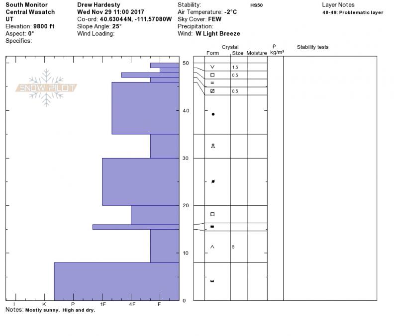
The good news - Many slopes on the southern half of the compass and at lower elevations remain snow free. When snowfall finally comes, these slopes may have a more stable snowpack because they won't harbor old, weak snow near the ground. The bad news - Because the snowpack is only 1-2 feet on upper elevation, northerly aspects, it is strongly affected by weather and will change a lot in the coming week. Unfortunately this time of year, it usually changes for the worse and becomes more weak and faceted. What about recent warm weather, didn't that help? Warm temperatures created wet layers of snow that are now refrozen. These crusts have simply made the snowpack more complicated with alternating layers of crusts and weak, faceted crystals. See Drew's recent snow profile below from a North facing slope at 9800 feet along the Park City Ridgeline. How to read this snow profile? The blue "bars" represent hardness. Long bars are harder snow. Short bars are softer snow. Think of it as a bunch of blocks stacked on top of each other. Any young child will tell you that stacking bigger blocks on top of smaller blocks is not a stable structure. It works the same for the snowpack. The only reason we don't have unstable conditions is that the snowpack lacks stress from the weight of new snow.
|
 |
recent activity There has been no reported avalanche activity since Saturday Nov 18. |
| type | aspect/elevation | characteristics |
|---|

|

|
LIKELIHOOD
 LIKELY
UNLIKELY
SIZE
 LARGE
SMALL
TREND
 INCREASING DANGER
SAME
DECREASING DANGER
|
|
description
The snowpack is generally stable and avalanches are unlikely. The greatest hazard is hitting rocks or stumps. This dry weather is a great opportunity to practice using your rescue gear or take a rescue class. We are offering one next Friday night at Brighton. Click HERE for more details or go HERE to find other classes. |
| type | aspect/elevation | characteristics |
|---|

|
|
LIKELIHOOD
 LIKELY
UNLIKELY
SIZE
 LARGE
SMALL
TREND
 INCREASING DANGER
SAME
DECREASING DANGER
|
|
description
The odds of triggering a persistent slab avalanche remain low because the snowpack has not been stressed by the weight of new snow. Looking ahead - Once we get more snow, this avalanche problem will be a serious hazard on upper elevation, northely aspects. The mostly likely layer on which avalanches will break after Sunday's storm will be the thin layer of small facets on top of a crust near the snow surface. However, winds from the SW on Sunday should drift snow onto NE aspects. With enough wind loading on NE facing slopes, avalanches may also break at the ground. |
 |
weather Today and Saturday will be dry and mostly sunny. A cold front will bring snow and cold temperatures on Sunday, and we may even see some snow in the valley. This storm could bring 6 inches of snow or even a little more. Sunday and Monday nights should see mountain temperatures drop into the single digits F. By Tuesday, dry conditions return and a ridge of high pressure will be overhead for the rest of the week. |
general announcements
|