25th Annual Black Diamond Fall Fundraising Party
Thursday, September 13; 6:00-10:00 PM; Black Diamond Parking Lot
25th Annual Black Diamond Fall Fundraising Party
Thursday, September 13; 6:00-10:00 PM; Black Diamond Parking Lot
| Advisory: Salt Lake Area Mountains | Issued by Drew Hardesty for Monday - November 20, 2017 - 5:43am |
|---|

|
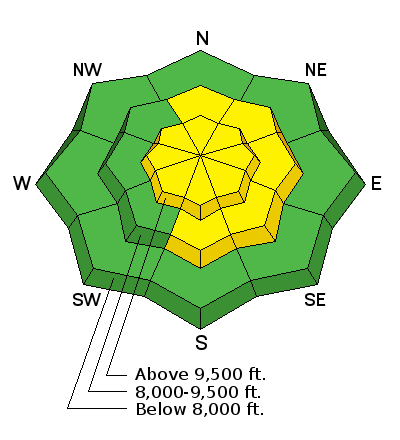
bottom line The danger is MODERATE for human triggered slides 1-2' deep and up to a few hundred feet wide. The good news is that this danger is generally confined to steep northwest to north to northeast facing slopes above - conservatively - 9000'. The bad news is that it may be possible to trigger these avalanches remotely or from below. The danger is also MODERATE for increasingly sensitive drifts on steep wind loaded terrain at the mid and upper elevations. The best news is that the best and safest riding conditions exist on low angle north facing grassy slopes not connected to steeper terrain. We'll update this advisory on Thanksgiving morning.
|
 |
special announcement Support the UAC when you shop. Between now and Jan 11th, Whole Foods Market at Trolley Square, Sugarhouse & Cottonwood Heights will donate a dime per bag to Utah Avalanche Center when you shop there and donate your bag credit at check out. See below or YouTube link to see a review of what's going on with our snowpack and our current avalanche concerns. YouTube link here. Special thanks to Steve Lloyd for this project. Unopened ski area terrain has a backcountry snowpack, as avalanche mitigation work has not been done. Each resort has different uphill travel policies - please abide by signage and closures and check in with the local ski patrol. Snowbird is closed to uphill traffic. Brighton has uphill policies in effect. Please check with their website or ski patrol for more info. |
 |
current conditions Skies are overcast. Mountain temps hover around freezing. At least the winds have picked up with this teaser moving by to the north. They're blowing 15-20mph, gusting to 30. They've yet to peak. 1-2' of snow sits on the ground in the upper elevations of the Cottonwoods and along the Park City ridgeline and riding conditions are fair on the north facing low angle grassy slopes. |
 |
recent activity No new avalanches were reported from the backcountry yesterday, but Greg Gagne found what looked to be a remotely triggered slide in the Catherine's area along the Alta periphery from Saturday. It failed two feet deep and 70' wide on a north facing slope just over 10,000' and running on old weak snow from October. Of note, the 70' width actually low-balls the magnitude of the avalanche as tensile cracks, or stress fractures spider-webbing beyond the flanks paint it more as 200' wide. Other observers still experienced cracking and collapsing in the slumgullion stew of weaknesses within our beleaguered snowpack, as - aside from all the graupel layers - weak faceted layers exist from September, October, and early November. It's a snowpack only a mother could love. Highlights from the weekend: Two natural avalanches during Friday's storm and one explosive-triggered monster in Collins Gulch of upper Little Cottonwood Canyon on Saturday.
|
| type | aspect/elevation | characteristics |
|---|

|
|
LIKELIHOOD
 LIKELY
UNLIKELY
SIZE
 LARGE
SMALL
TREND
 INCREASING DANGER
SAME
DECREASING DANGER
|
|
description
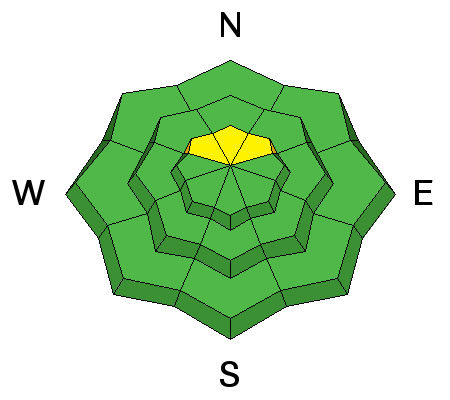
Continued cracking and collapsing (photo from yesterday) along with damning snowpit tests continue to point toward instability and danger within the snowpack. These various weaknesses are eminently collapsible with the additional weight of a backcountry traveler and may thus be triggered from adjacent slopes or below. An interesting pattern is that most of these avalanches displayed surprisingly wide propagation - in some cases up to a half-mile wide. Unfortunately, persistent weak layers live up to their name and are going to be around for awhile.
|
| type | aspect/elevation | characteristics |
|---|

|
|
LIKELIHOOD
LIKELY
UNLIKELY
SIZE
LARGE
SMALL
TREND
 INCREASING DANGER
SAME
DECREASING DANGER
|
|
description
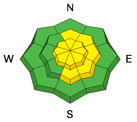
Increasing westerly winds should put active and sensitive wind drifts on the radar. These drifts will be more pronounced on steep slopes with an easterly component, but terrain channeling may allow for drifts to be found on many possible aspects. Be particularly alert for drifts to the lee of ridgelines and cross-loaded in couloirs and gullies. |
 |
weather We'll be under overcast skies with warm temps and gusty west to northwest winds to the tune of 25-35mph. Ridgetop temps push to the mid-40s by Thursday. Despite a few weak "storms" here and there, the longer range models look a bit bleak at the moment. |
| general announcements Remember your information can save lives. If you see anything we should know about, please help us out by submitting snow and avalanche conditions. You can also call us at 801-524-5304, email by clicking HERE, or include #utavy in your tweet or Instagram. To get help in an emergency (to request a rescue) in the Wasatch, call 911. Be prepared to give your GPS coordinates or the run name. Dispatchers have a copy of the Wasatch Backcountry Ski map. Backcountry Emergencies. It outlines your step-by-step method in the event of a winter backcountry incident. If you trigger an avalanche in the backcountry, but no one is hurt and you do not need assistance, please notify the nearest ski area dispatch to avoid a needless response by rescue teams. Thanks.
EMAIL ADVISORY If you would like to get the daily advisory by email you will need to subscribe here. DAWN PATROL Hotline updated daily by 5-530am - 888-999-4019 option 8. TWITTER Updates for your mobile phone - DETAILS UDOT canyon closures: LINK TO UDOT, or on Twitter, follow @UDOTavy, @CanyonAlerts or @AltaCentral Utah Avalanche Center mobile app - Get your advisory on your iPhone along with great navigation and rescue tools. Powderbird Helicopter Skiing - Blog/itinerary for the day Lost or Found something in the backcountry? - http://nolofo.com/ To those skinning uphill at resorts: it is critical to know the resort policy on uphill travel. You can see the uphill travel policy for each resort here. Benefit the Utah Avalanche Center when you shop from Backcountry.com or REI: Click this link for Backcountry.com or this link to REI, shop, and they will donate a percent of your purchase price to the UAC. Both offer free shipping (with some conditions) so this costs you nothing! Benefit the Utah Avalanche Center when you buy or sell on ebay - set the Utah Avalanche Center as a favorite non-profit in your ebay account here and click on ebay gives when you buy or sell. You can choose to have your seller fees donated to the UAC, which doesn't cost you a penny. This information does not apply to developed ski areas or highways where avalanche control is normally done. This advisory is from the U.S.D.A. Forest Service, which is solely responsible for its content. This advisory describes general avalanche conditions and local variations always occur. |


