25th Annual Black Diamond Fall Fundraising Party
Thursday, September 13; 6:00-10:00 PM; Black Diamond Parking Lot
25th Annual Black Diamond Fall Fundraising Party
Thursday, September 13; 6:00-10:00 PM; Black Diamond Parking Lot
| Advisory: Salt Lake Area Mountains | Issued by Evelyn Lees for Saturday - November 18, 2017 - 6:00am |
|---|

|
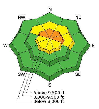
bottom line The avalanche danger is CONSIDERABLE on steep, upper elevation northwest through easterly facing slopes, where human triggered avalanches are likely. Here, slides could break into older faceted snow, and be triggered remotely from a distance or from below. Also avoid any steep slope with wind-drifted snow, which have a MODERATE danger. Getting caught in an early season avalanche is especially dangerous due to all the rocks and the potential for trauma. Instead, head to low angle slopes (about 32 degrees or less steep), with no steep slopes above or slopes that were bare ground before the storm - sunny slopes facing southeast through west. We will update this forecast Sunday morning, with additional forecasts as conditions warrant.
|
 |
special announcement The below video (click here for link) reviews what's going on with our snowpack and our current avalanche concerns. Unopened ski area terrain has a backcountry snowpack, as avalanche mitigation work has not been done. Each resort has different uphill travel policies - please abide by signage and closures and check in with the local ski patrol. Snowbird and Alta are closed to uphill traffic. While the Albion summer road is open, Alta will be doing mitigation in the Supreme area and East Castle to protect lift construction. |
 |
current conditions Skies are clear this morning and temperatures are in the single digits to low teens. The winds are from the northwest, and generally averaging less than 10 mph, with the higest peaks averaging 20 mph. Here are storm totals, with estimates of total snow on the ground: Ogden area mountains: 12 – 18” of new snow, landing on mostly bare ground. Salt Lake area mountains: 9 to 17” of new snow, with up to 2 feet of snow on the ground in the upper elevations of the Cottonwoods Park City area mountains: 8 – 14” of new snow, with 10 to 20” on the ground at upper elevations Provo area mountains: 2 to 5” of new snow, above about 6,000’ |
 |
recent activity No avalanche activity was reported yesterday, but reports of collapsing and cracking came in from upper Little Cottonwood and Snake Creek. Peak of any natural avalanche activity would have been yesterday; today will be the peak of human triggered avalanches. |
| type | aspect/elevation | characteristics |
|---|

|
|
LIKELIHOOD
 LIKELY
UNLIKELY
SIZE
 LARGE
SMALL
TREND
 INCREASING DANGER
SAME
DECREASING DANGER
|
|
description
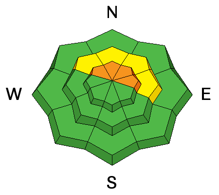
Before the storm, there was weak sugary snow on upper elevation slopes facing northwest thorough easterly, both at the surface and near the ground. Yesterday’s new snow has put a slab on this weak layer, and human triggered avalanches are likely today on steep, upper elevation shady slopes. With facets as a weak layer, you can trigger slides from a distance or from below. The “whiter” and more “filled in” a slope looks, the more likely it is to have the dangerous weak old snow beneath the new. Typical of early season, there is a lot of variability in the snow over short distances, so tracks or a snow pit on one slope may not represent the stability 50 or 100 feet away. |
| type | aspect/elevation | characteristics |
|---|

|
|
LIKELIHOOD
 LIKELY
UNLIKELY
SIZE
LARGE
SMALL
TREND
 INCREASING DANGER
SAME
DECREASING DANGER
|
|
description
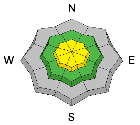
Yesterday, strong winds blew first from the south, then from the northwest after frontal passage. 25 mph averages were the norm, with the highest peaks and ridgelines averaging in the 40s and 50s, gusting to 80 mph. The winds were blowing and drifting the snow, especially at the higher elevations, along ridgelines and on open slopes. Indications you are in a wind-drifted area include finding deeper denser snow or cracking within the new snow. Jump on small test slopes, but avoid steep slopes with wind drifts. Even out of wind-affected terrain, there may be poor bonding of the new snow to the slick or sugary old snow surfaces. |
 |
weather High pressure will build across the region today, bringing a warming trend through Sunday. Mostly sunny skies today, with 10,000’ highs in the upper 20s and light westerly winds below 10,000', and average speeds of 20 to 30 mph at the highest elevations. Sunday will be similar, though even warmer, with 10,000’ temperatures in the upper 30s. A weak storm system will graze the area on Monday, followed by unseasonably warm and dry weather. |
| general announcements Remember your information can save lives. If you see anything we should know about, please help us out by submitting snow and avalanche conditions. You can also call us at 801-524-5304, email by clicking HERE, or include #utavy in your tweet or Instagram. To get help in an emergency (to request a rescue) in the Wasatch, call 911. Be prepared to give your GPS coordinates or the run name. Dispatchers have a copy of the Wasatch Backcountry Ski map. Backcountry Emergencies. It outlines your step-by-step method in the event of a winter backcountry incident. If you trigger an avalanche in the backcountry, but no one is hurt and you do not need assistance, please notify the nearest ski area dispatch to avoid a needless response by rescue teams. Thanks.
EMAIL ADVISORY If you would like to get the daily advisory by email you will need to subscribe here. DAWN PATROL Hotline updated daily by 5-530am - 888-999-4019 option 8. TWITTER Updates for your mobile phone - DETAILS UDOT canyon closures: LINK TO UDOT, or on Twitter, follow @UDOTavy, @CanyonAlerts or @AltaCentral Utah Avalanche Center mobile app - Get your advisory on your iPhone along with great navigation and rescue tools. Powderbird Helicopter Skiing - Blog/itinerary for the day Lost or Found something in the backcountry? - http://nolofo.com/ To those skinning uphill at resorts: it is critical to know the resort policy on uphill travel. You can see the uphill travel policy for each resort here. Benefit the Utah Avalanche Center when you shop from Backcountry.com or REI: Click this link for Backcountry.com or this link to REI, shop, and they will donate a percent of your purchase price to the UAC. Both offer free shipping (with some conditions) so this costs you nothing! Benefit the Utah Avalanche Center when you buy or sell on ebay - set the Utah Avalanche Center as a favorite non-profit in your ebay account here and click on ebay gives when you buy or sell. You can choose to have your seller fees donated to the UAC, which doesn't cost you a penny. This information does not apply to developed ski areas or highways where avalanche control is normally done. This advisory is from the U.S.D.A. Forest Service, which is solely responsible for its content. This advisory describes general avalanche conditions and local variations always occur. |


