25th Annual Black Diamond Fall Fundraising Party
Thursday, September 13; 6:00-10:00 PM; Black Diamond Parking Lot
25th Annual Black Diamond Fall Fundraising Party
Thursday, September 13; 6:00-10:00 PM; Black Diamond Parking Lot
| Advisory: Salt Lake Area Mountains | Issued by Evelyn Lees for Sunday - April 9, 2017 - 6:38am |
|---|

|
bottom line CONSIDERABLE Avalanche Danger on steep, upper elevation slopes with recent drifts of wind blown snow. Human triggered avalanche likely, natural avalanche possible. Avoid avalanche run out zones. MODERATE Avalanche Danger of triggering new snow soft slabs and sluffs, even out of the wind-affected terrain, MODERATE Avalanche Danger when the sun comes out later today for triggering wet loose sluffs on steep, sunny slopes. GO TO TERRAIN: acres of untracked powder on wind-sheltered slopes less steep than about 35 degrees, providing excellent turning and riding conditions.
|
 |
current conditions Today could be THE POWDER DAY of April…a cold, moist storm has dropped 12 to 18” in the Ogden area mountains and the Cottonwoods, with 6 to 14” along the Park City ridge line and 3 to 6” in the Provo area mountains. It’s a “right side up” storm, with lighter snow falling on a dense graupel base from yesterday. The wintery morning temperatures are in the teens and single digits. Unfortunately, the pesky west to northwesterly winds are averaging 15 to 20 mph, gusting 35 to 45, with the highest peaks averaging to 45, gusting in the 70s. |
 |
recent activity No avalanche activity reported from yesterday. |
| type | aspect/elevation | characteristics |
|---|

|
|
LIKELIHOOD
 LIKELY
UNLIKELY
SIZE
 LARGE
SMALL
TREND
 INCREASING DANGER
SAME
DECREASING DANGER
|
|
description
The winds are a spoiler – in the last 24 hours, there have been periods of moderate to strong winds from the south, west and now northwest. Be prepared to find sensitive wind drifts on almost any aspect in upper and mid elevation terrain, both along the ridge lines and on open wind exposed slopes, along gully walls and at slope break overs. Avoid any steep, wind-drifted slopes and seek wind-sheltered terrain. Both the wind speeds and the avalanche danger increase with elevation - travel to the 11,000' peaks and in the high alpine terrain is not recommended today. Avoid any new cornices, and continue to stay well back from the edges of the huge old cornices along the ridge lines, and avoid travel beneath them. The fresh snow and flat light make it very hard to realize how overhung they are. |
| type | aspect/elevation | characteristics |
|---|

|
|
LIKELIHOOD
 LIKELY
UNLIKELY
SIZE
 LARGE
SMALL
TREND
 INCREASING DANGER
SAME
DECREASING DANGER
|
|
description
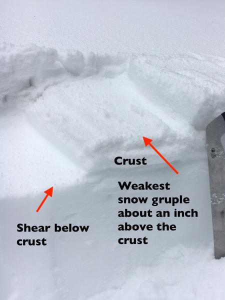
Loose sluffs and soft slabs can be triggered today in the 1 to 2 feet of fresh powder on steep slopes. Yesterday, a weak layer of graupel was at the base of new snow, a potential weak layer today. Graupel also pooled beneath cliffs and gullies yesterday, allowing for potentially deeper slides. Yesterday’s layering - which now has 1 to 2 feet of snow on top. Dig down below the crust as part of your snow stability analysis.
|
| type | aspect/elevation | characteristics |
|---|

|
|
LIKELIHOOD
 LIKELY
UNLIKELY
SIZE
LARGE
SMALL
TREND
 INCREASING DANGER
SAME
DECREASING DANGER
|
|
description
The sun is forecast to come out this afternoon, and is so strong this time of year it will almost instantly dampen the snow. It will become easy to trigger wet loose sluffs on steep sunny slopes, so be ready to get off steep slopes if the snow heats where you are. I don’t know if natural wet loose sluffs will be possible, but if the snow heats up, avoid travel below steep slopes and especially confined gullies. |
 |
weather Snow showers should taper off by late morning, with partial clearing this afternoon. An additional 2 to 4” of snow is possible, mostly before 10 am. The gusty northwesterly winds are forecast to decrease during the day, with averages dropping to 10 to 20 mph, with the highest peaks still averaging 25 mph with gusts in the 30s. Temperatures will remain delightfully cool – in the teens at 10,000’ and near 30°F at 8,000’. Cold and clear tonight. A drier west to southwest flow will develop overnight and persist through Tuesday with a gradual warming trend. More snow is possible for the mountains next Friday. |
general announcements
|