25th Annual Black Diamond Fall Fundraising Party
Thursday, September 13; 6:00-10:00 PM; Black Diamond Parking Lot
25th Annual Black Diamond Fall Fundraising Party
Thursday, September 13; 6:00-10:00 PM; Black Diamond Parking Lot
| Advisory: Salt Lake Area Mountains | Issued by Evelyn Lees for Monday - April 3, 2017 - 6:12am |
|---|

|
bottom line The avalanche danger is LOW today, though small avalanches can still be triggered in isolated terrain.
|
 |
special announcement Thanks for everyone that donated to organizations that make living in Utah a better place during yesterday's Love Utah Give Utah. We here at the Utah Avalanche Center gratefully appreciate the support we receive from this amazing community. |
 |
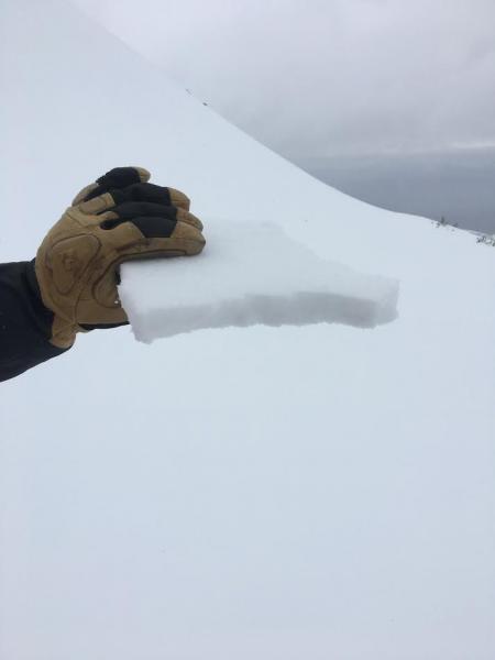
current conditions If there was a storm, I blinked and missed it…accumulations yesterday were a trace to 2”, with the rain/snow line above 7,000’ at times. Temperatures have been dropping steadily overnight, and are in the teens and to mid twenties this morning. Winds are from the northwest, averaging 10 to 15 mph, with the 11,000’ peaks averaging 30 mph at times. While the hard snow surfaces make for fast travel, they are icy enough to make travel dangerous on steep slopes, with potentially knee twisting breakable crusts mixed in. There's the surface crust - breakable in places. Primrose Cirque, Provo area mountains, Tyler Falk photo.
|
 |
recent activity No avalanche activity reported from yesterday. |
| type | aspect/elevation | characteristics |
|---|

|
|
LIKELIHOOD
 LIKELY
UNLIKELY
SIZE
 LARGE
SMALL
TREND
 INCREASING DANGER
SAME
DECREASING DANGER
|
|
description
Wind slabs: hard, shallow wind drifts may be scattered along the high ridge lines this morning, created by the overnight northwesterly winds. It is a matter of terrain – if one cracks out beneath you on a steep slope, knocking you off balance, it’s possible to go for a long ride down an icy slope or get sent over a cliff. Cornices: The huge cornices can still fail with the additional weight of a person. Stay well back from their edges, and avoid travel below them. Slide for life: If you plan to travel in steep, icy terrain, have a way to prevent a slide for life from happening. Whippets, mountaineering axe, crampons and/or using a rope to belay are safety measures that can help prevent an accident. |
 |
weather Northern Utah is sandwiched between storms to the north and south today, producing partly to mostly cloudy skies, with a few snow flurries possible. As cold air filters in, 10,000’ temperatures will cool into to the mid teens today and down near 10 degrees by tomorrow morning. Expect the northwesterly winds to average 10 to 15 mph in most terrain, with the highest peaks averaging to 30 mph, with gusts to 40 mph at times. A similar cool, partly cloudy day tomorrow will be followed by a warming trend on Wednesday and Thursday. Friday, expect increasing winds ahead of a cold storm projected for the weekend. |
general announcements
|