25th Annual Black Diamond Fall Fundraising Party
Thursday, September 13; 6:00-10:00 PM; Black Diamond Parking Lot
25th Annual Black Diamond Fall Fundraising Party
Thursday, September 13; 6:00-10:00 PM; Black Diamond Parking Lot
| Advisory: Salt Lake Area Mountains | Issued by Trent Meisenheimer for Sunday - April 2, 2017 - 4:54am |
|---|

|
bottom line Today we have a LOW avalanche danger on all aspects and elevations.
|
 |
special announcement Thanks for everyone that donated to organizations that make living in Utah a better place during yesterday's Love Utah Give Utah. We here at the Utah Avalanche Center gratefully appreciate the support we receive from this amazing community. |
 |
current conditions Mostly clear skies will make way to increasing clouds by early morning as a cold front from the north pushes towards us. Current temperatures are below freezing at almost all weather stations above 7000' feet in elevation. Winds are out of the west and north blowing 10-15 mph with gusts into the 20's at upper elevations. The snow surface this morning will be supportable and travel should be easy. If you're thinking of corn snow get it early and good luck. I am unsure if the snow surface will soften much this morning. If it does soften - it wont stay soft for long with the approaching cooler temps and cloud cover expected by noon. There is soft settled powder capped with a thin crust on the highest due north aspects. Week in Review by Greg Gagne - [Detailed Version] |
 |
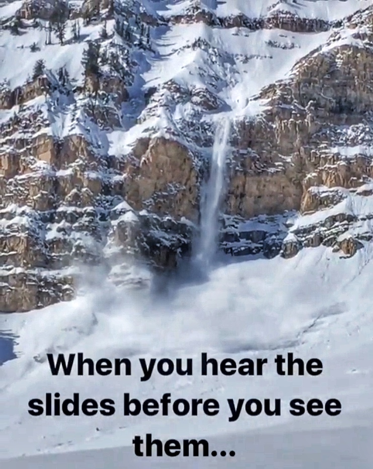
recent activity Yesterday the heat wave came sooner than expected to the mountains and created a natural wet loose avalanche cycle. Many backcountry travelers reported the loose wet activity starting as early as 9:00 am on the steeper sun lit slopes. Down south one party had to turn around on Timpanogos when roller-balls started showering down upon them - they also observed a natural avalanche that poured over a 100' foot cliff. (Picture below) Photo of a natural avalanche down in Timpanogos. (Photo: wasatchavyobs)
|
| type | aspect/elevation | characteristics |
|---|

|

|
LIKELIHOOD
 LIKELY
UNLIKELY
SIZE
 LARGE
SMALL
TREND
 INCREASING DANGER
SAME
DECREASING DANGER
|
|
description
WET LOOSE AVALANCHES - This morning we may see a period of sunshine, perhaps enough that it may soften the snow surface. As the sun comes out; remember to always be aware of what slopes are above or adjacent to you - especially those that are heating up. If you see roller balls trickling down it's time to switch aspects or move to lower angle terrain. LOOSE DRY / WIND ISSUES - As a fast moving cold front comes in this morning be prepared to shift your focus from loose wet to dry snow avalanches. Especially, if we get a period of intense snow fall where it stacks up rapidly. If winds kick up more than expected and or we receive more snow than expected, you can bet on loose dry avalanches sliding on the old slick surfaces and touchy shallow wind slabs on the leeward side of the mountain. It's spring and conditions can change minute by minute. CORNICE - These monsters are still hanging in balance. If you're walking ridges today remember that these beasts are overhanging and often times break way further back than expected. SLIDE FOR LIFE - Hard icy surfaces can lead to slipping and without a way to self arrest could be tragic. If you find your-self in steep terrain today have a way to prevent a slide for life from happening. Whippets, mountaineering axe, and or crampons are all good tools to carry. |
 |
weather This morning we have cooling temperatures and increasing cloud cover as a small cold front pushes into the mountains of northern Utah. As the storm arrives we should start seeing snow flurries by late morning and into early afternoon. Winds will be light and out of the north blowing 10-20 mph with gusts into the 20's at the upper elevations. We should see 2"-5" inches (0.3"-0.6" h20) of snow by the dinner hour. The storm exits the area and high pressure returns for Monday. |
general announcements
|