25th Annual Black Diamond Fall Fundraising Party
Thursday, September 13; 6:00-10:00 PM; Black Diamond Parking Lot
25th Annual Black Diamond Fall Fundraising Party
Thursday, September 13; 6:00-10:00 PM; Black Diamond Parking Lot
| Advisory: Salt Lake Area Mountains | Issued by Drew Hardesty for Wednesday - March 29, 2017 - 6:01am |
|---|


|
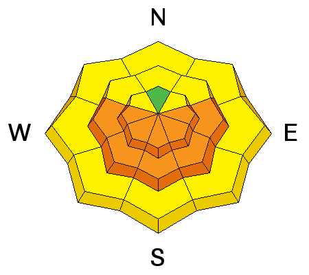
bottom line By mid to late morning, the danger will rise toward CONSIDERABLE for wet loose and perhaps wet slab avalanches on east, then south, then westerly aspects. Northeast and northwest aspects will also be susceptible to sun and heating. Wet avalanche activity is a certainty and I expect to see decent wet debris piles beneath steep sustained terrain features as the wet avalanches run not fast but far as they entrain all the snow down to the underlying melt-freeze crusts. Isolated pockets of wind slab may still be sensitive to human weight or cornice fall in steep upper elevation terrain.
|
 |
special announcement Thursday, March 30, is Love Utah Give Utah day. Between now and then, when you donate to the charities that make living in Utah better using this link, you will automatically be entered to win a 3 year lease on a 2017 Subaru Impreza from Mark Miller Subaru. Plus getting karma points and benefiting your community. The Utah Avalanche Center counts on partners like you for support. https://loveutgiveut.razoo.com/story/Utahavalanchecenter Support Wasatch Backcountry Rescue at the 3rd Annual Bow Wow fundraiser on Thursday, March 30th at 6pm at OP Rockwells in Park City. Details HERE. |
 |
current conditions Skies are mostly clear with mountain temps in the upper teens to low 20s. Winds remain northerly, blowing 15-20mph with gusts to 25 along the high ridgelines. Sun and heating put the hurt on all aspects and elevations but high north yesterday and you'll find breakable crusts across the landscape prior to the the morning thaw. High true north holds the last vestiges of soft snow although wind damage and pockets of hard wind slab have damaged much of what's left. Still, for the aesthete, it was hard not to be taken by the spines of rime on the trees. Early Monday's clouds of super-cooled water droplets gave the tree branches a look not unlike that of cholla or ocotillo found in the Mojave. This morning, you might even find hints of surface hoar across the landscape before it decays from sun and wind.
|
 |
recent activity Yesterday's activity is derived from the moderate to strong northerly winds and the irrepressible late March sun and heating. Thanks - as always - for your excellent reports and observations from the backcountry.
|
| type | aspect/elevation | characteristics |
|---|

|
|
LIKELIHOOD
 LIKELY
UNLIKELY
SIZE
 LARGE
SMALL
TREND
 INCREASING DANGER
SAME
DECREASING DANGER
|
|
description
Although there was some wet activity yesterday, there was just enough wind and cloud cover to keep the entire snowpack from unraveling. We won't be afforded such mitigating factors today. With full sun and rapidly rising temps, wet sluffs and slabs will be likely on a variety of aspects and elevations. Avoid traveling in steep sunny terrain where the snow surface becomes wet and unstable. There's no secret here: look for the tell-tale signs of wet snow instability: pinwheels, rollerballs, natural sluffs, wet unsupportable snow. |
| type | aspect/elevation | characteristics |
|---|

|
|
LIKELIHOOD
 LIKELY
UNLIKELY
SIZE
LARGE
SMALL
TREND
 INCREASING DANGER
SAME
DECREASING DANGER
|
|
description
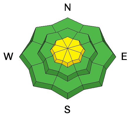
Isolated pockets of lingering wind slab may still be triggered in the high alpine and in the open exposed bowls in the upper elevations. (Many steep northerly starting zones were scoured, but no need to split hairs on the rose above.) Shooting cracks, audible collapsing, and that tactile feel of moving from soft turnable snow to stop-you-in-your tracks ... these are all red to yellow signs for caution. In the photo below, you can see the crack and the distant avalanche below (pc Gleich)
|
| type | aspect/elevation | characteristics |
|---|

|
|
LIKELIHOOD
 LIKELY
UNLIKELY
SIZE
 LARGE
SMALL
TREND
 INCREASING DANGER
SAME
DECREASING DANGER
|
|
description
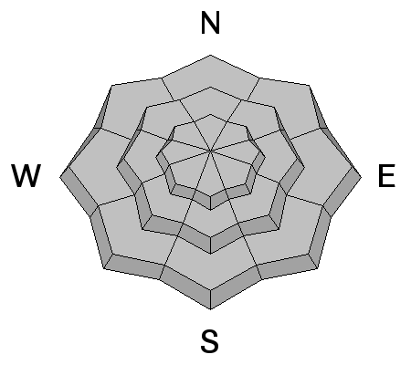
We're sounding like a broken record, but cornices and glide cracks should be considered significant objective hazards that should be avoided with care. |
 |
weather We'll have mostly sunny skies with mountain temperatures rising to the upper 40s at 8500' and near 30°F at 10,000'. Winds will be northerly at 10-15mph. We should see some high clouds on the horizon in the afternoon signaling the advance of a large low pressure system that moves in tomorrow through early Saturday. Closed Low pressure systems are often accompanied with great uncertainty for precipitation totals, but I'd hedge with 5-10" by early Saturday. The insult will be in the form of strong easterly winds Friday into Saturday. Stay tuned. |
| general announcements Remember your information can save lives. If you see anything we should know about, please help us out by submitting snow and avalanche conditions. You can also call us at 801-524-5304, email by clicking HERE, or include #utavy in your tweet or Instagram. To get help in an emergency (to request a rescue) in the Wasatch, call 911. Be prepared to give your GPS coordinates or the run name. Dispatchers have a copy of the Wasatch Backcountry Ski map. Backcountry Emergencies. It outlines your step-by-step method in the event of a winter backcountry incident. If you trigger an avalanche in the backcountry, but no one is hurt and you do not need assistance, please notify the nearest ski area dispatch to avoid a needless response by rescue teams. Thanks.
EMAIL ADVISORY If you would like to get the daily advisory by email you will need to subscribe here. DAWN PATROL Hotline updated daily by 5-530am - 888-999-4019 option 8. TWITTER Updates for your mobile phone - DETAILS UDOT canyon closures: LINK TO UDOT, or on Twitter, follow @UDOTavy, @CanyonAlerts or @AltaCentral Utah Avalanche Center mobile app - Get your advisory on your iPhone along with great navigation and rescue tools. Powderbird Helicopter Skiing - Blog/itinerary for the day Lost or Found something in the backcountry? - http://nolofo.com/ To those skinning uphill at resorts: it is critical to know the resort policy on uphill travel. You can see the uphill travel policy for each resort here. Benefit the Utah Avalanche Center when you shop from Backcountry.com or REI: Click this link for Backcountry.com or this link to REI, shop, and they will donate a percent of your purchase price to the UAC. Both offer free shipping (with some conditions) so this costs you nothing! Benefit the Utah Avalanche Center when you buy or sell on ebay - set the Utah Avalanche Center as a favorite non-profit in your ebay account here and click on ebay gives when you buy or sell. You can choose to have your seller fees donated to the UAC, which doesn't cost you a penny. This information does not apply to developed ski areas or highways where avalanche control is normally done. This advisory is from the U.S.D.A. Forest Service, which is solely responsible for its content. This advisory describes general avalanche conditions and local variations always occur |


