25th Annual Black Diamond Fall Fundraising Party
Thursday, September 13; 6:00-10:00 PM; Black Diamond Parking Lot
25th Annual Black Diamond Fall Fundraising Party
Thursday, September 13; 6:00-10:00 PM; Black Diamond Parking Lot
| Advisory: Salt Lake Area Mountains | Issued by Evelyn Lees for Monday - March 27, 2017 - 6:37am |
|---|

|
bottom line The avalanche danger will increase to MODERATE on steep mid and upper elevation slopes of all aspects as the snow adds up today. The slick sun crusts will act as good bed surfaces, and slides may be long running. By late afternoon and overnight, the danger may rise to CONSIDERABLE on wind-drifted, upper elevation slopes, with natural avalanches possible. Continue to avoid travel below the large cornices and opening glide cracks
|
 |
special announcement Thursday, March 30, is Love Utah Give Utah day. Between now and then, when you donate to the charities that make living in Utah better using this link, you will automatically be entered to win a 3 year lease on a 2017 Subaru Impreza from Mark Miller Subaru. Plus getting karma points and benefiting your community. The Utah Avalanche Center counts on partners like you for support. https://loveutgiveut.razoo.com/story/Utahavalanchecenter Support Wasatch Backcountry Rescue at the 3rd Annual Bow Wow fundraiser on Thursday, March 30th at 6pm at OP Rockwells in Park City. Details HERE. |
 |
current conditions The next storm has just arrived, with accumulations of a trace to 2” of new snow as of 6 am. Temperatures range from the low 20s to low 30s, and the southwesterly winds are light, averaging 10 to 15 mph. |
 |
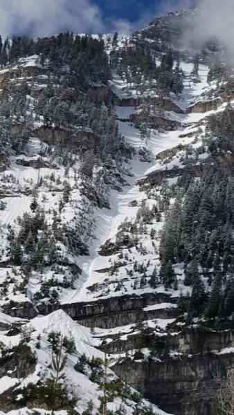
recent activity Classic spring avalanche activity yesterday – dry loose sluffs triggered early in the morning, with wet loose sluffs starting by 10 am. Two larger natural wet sluffs occurred on Primrose and Barrieto, with numerous smaller wet sluffs triggered through out the day. Friday's sun crust served as a good bed surface. A few shallow wind slabs were triggered at the upper elevations. Left - Primrose Cirque natural, Timpanogos (PC: Geoff Larson) Right - Triggered wet loose sluff, Butler Basin (PC: Sean)
|
| type | aspect/elevation | characteristics |
|---|

|
|
LIKELIHOOD
 LIKELY
UNLIKELY
SIZE
 LARGE
SMALL
TREND
 INCREASING DANGER
SAME
DECREASING DANGER
|
|
description
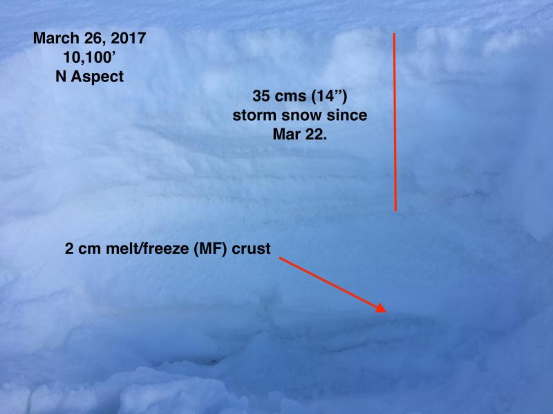
The avalanche danger will increase today and tonight as the new snow adds up, especially on wind drifted slopes. Sunday's sun crust will now act as the latest slick bed surface on most mid and upper elevation aspects. With the new snow bonding poorly to the icy crusts, slides will run further and faster than expected, entraining snow and having deeper than normal debris piles. On upper elevation, northerly facing slopes, the last few storms are starting to add up, and it may be possible to trigger a slab avalanche taking out more than just today’s snow. Steep terrain with new or old wind drifts and slopes where graupel pooled below cliff bands are extra suspect, where slides 1 to 2’ deep may be triggered by evening. The Greg Gagne photo below shows how the upper elevation snow pack on northerly facing slopes is becoming layered and more suspect with potential weak layers.
|
| type | aspect/elevation | characteristics |
|---|

|
|
LIKELIHOOD
 LIKELY
UNLIKELY
SIZE
LARGE
SMALL
TREND
 INCREASING DANGER
SAME
DECREASING DANGER
|
|
description
Wet Loose: While the snowpack slowly cools, it still may be possible to trigger a few wet loose sluffs today or have a slide gouge into the old wet snow, mostly at the mid and lower elevations. Cornices and Glide cracks: Avoidance is key for both of these. Minimize any travel beneath them, and be aware they can run long distances if they fail. With cornices, also stay well back from their edges as you travel along ridge lines. They tend to break back much further than expected, onto what looks like flat terrain. |
 |
weather An energetic spring storm will bring a nice shot of snow today and tonight. Several inches of snow will fall on a southwesterly flow this morning, with frontal passage around noon. There’s a 15% a chance for lightning today, and periods of heavy snowfall are possible this afternoon and tonight on the northwesterly flow. 5 to 9” of snow is possible today, with another 5 to 9” tonight. This morning’s light southwesterly winds will increase when they shift to the northwest around noon, with 20 mph averages at the mid elevations, and the high ridgelines averaging 25 mph, gusting to 40 mph. The rain/snow line will drop to around 6,500’ this afternoon, and 5,000’ tonight. |
| general announcements Remember your information can save lives. If you see anything we should know about, please help us out by submitting snow and avalanche conditions. You can also call us at 801-524-5304, email by clicking HERE, or include #utavy in your tweet or Instagram. To get help in an emergency (to request a rescue) in the Wasatch, call 911. Be prepared to give your GPS coordinates or the run name. Dispatchers have a copy of the Wasatch Backcountry Ski map. Backcountry Emergencies. It outlines your step-by-step method in the event of a winter backcountry incident. If you trigger an avalanche in the backcountry, but no one is hurt and you do not need assistance, please notify the nearest ski area dispatch to avoid a needless response by rescue teams. Thanks.
EMAIL ADVISORY If you would like to get the daily advisory by email you will need to subscribe here. DAWN PATROL Hotline updated daily by 5-530am - 888-999-4019 option 8. TWITTER Updates for your mobile phone - DETAILS UDOT canyon closures: LINK TO UDOT, or on Twitter, follow @UDOTavy, @CanyonAlerts or @AltaCentral Utah Avalanche Center mobile app - Get your advisory on your iPhone along with great navigation and rescue tools. Powderbird Helicopter Skiing - Blog/itinerary for the day Lost or Found something in the backcountry? - http://nolofo.com/ To those skinning uphill at resorts: it is critical to know the resort policy on uphill travel. You can see the uphill travel policy for each resort here. Benefit the Utah Avalanche Center when you shop from Backcountry.com or REI: Click this link for Backcountry.com or this link to REI, shop, and they will donate a percent of your purchase price to the UAC. Both offer free shipping (with some conditions) so this costs you nothing! Benefit the Utah Avalanche Center when you buy or sell on ebay - set the Utah Avalanche Center as a favorite non-profit in your ebay account here and click on ebay gives when you buy or sell. You can choose to have your seller fees donated to the UAC, which doesn't cost you a penny. This information does not apply to developed ski areas or highways where avalanche control is normally done. This advisory is from the U.S.D.A. Forest Service, which is solely responsible for its content. This advisory describes general avalanche conditions and local variations always occur |


