25th Annual Black Diamond Fall Fundraising Party
Thursday, September 13; 6:00-10:00 PM; Black Diamond Parking Lot
25th Annual Black Diamond Fall Fundraising Party
Thursday, September 13; 6:00-10:00 PM; Black Diamond Parking Lot
| Advisory: Salt Lake Area Mountains | Issued by Greg Gagne for Friday - March 24, 2017 - 5:07am |
|---|


|
bottom line During the early morning the hazard is Moderate for fresh wind drifts found primarily on easterly upper elevation aspects. Outside of wind-affected terrain, the hazard will be Low early this morning. Once the sun begins to warm the snow surface (by mid to late morning) the hazard rises to Moderate first on east, followed by south and west aspects for loose wet avalanches. All low elevation aspects are susceptible to wet avalanches as well. Be sure to get off and and out from underneath any steep slopes that are undergoing warming from the sun.
|
 |
special announcement
|
 |
current conditions Temperatures this morning range from the high teens to mid 20's F and skies are clear. West/northwest winds picked up in the evening, and gusted in the 20's and 30's for about 6 hours, but they have been backing down since midnight and are now generally light and blowing < 10 mph, with some gusts in the teens at upper elevations. Snowfall amounts from Thursday are generally from 6-10" across the central Wasatch. This was 10% density storm snow on top of the 2-5" of very dense graupel that fell on Wednesday. For weather nerds, the 1.97" of water on Thursday was the 6th wettest day ever recorded at the Salt Lake airport, and the wettest March day ever. (A lack of orographic lift also meant valley locations received higher water amounts than the mountains.) [Week in Review] The prolonged ridge of high pressure (aka the "Dylan Ridge") continued through the weekend of March 18/19 with breezy conditions ahead of a week system that produced a few mountain rain showers and a trace of graupel on Monday. Skies cleared somewhat later Tuesday, and Wednesday brought a warm, moist storm system that deposited up to 5" of dense graupel, with 20% density. The rain/snow line was above 9500' During this past week, many mountain locations maintained above freezing temperatures for well over a week. On Thursday a moist storm system arrived, bringing the first legitimate storm snow since March 6. The high rain/snow line from Wednesday dropped down to the benches by mid-day Thursday. Wednesday/Thursday snow/water amounts include: Little Cottonwood 13.5"/1.86" |
 |
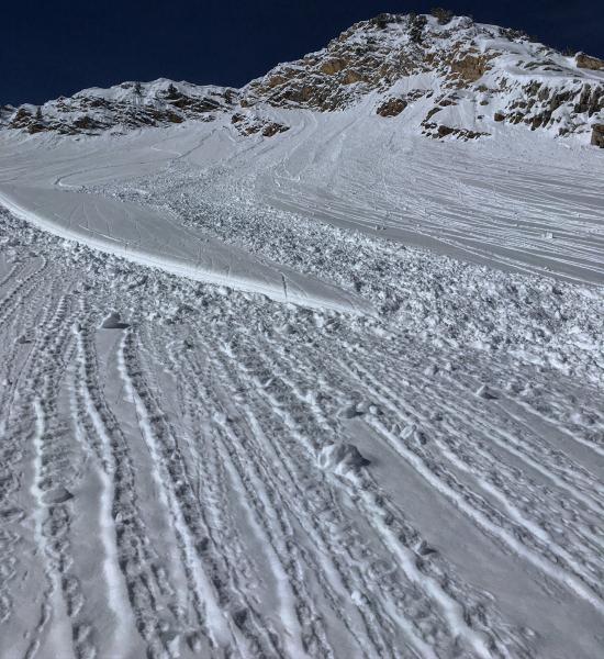
recent activity My partner and I were finding a poor bond between the Wednesday graupel and Thursday storm snow. We were able to trigger small to medium-sized loose snow avalanches in steep terrain that were failing at this interface. We had also found at least 7 natural avalanches in north-facing Cardiac Bowl. Other observers were reporting human triggered slides in Cardiff Fork, Millicent Peak, and south facing aspects above Alta. A Cottonwood resort had also reported natural activity in the storm snow throughout the day on Thursday. The reported avalanche activity was generally harmless class 1, but also included several class 2 avalanches (enough to bury a person). |
| type | aspect/elevation | characteristics |
|---|

|
|
LIKELIHOOD
 LIKELY
UNLIKELY
SIZE
 LARGE
SMALL
TREND
 INCREASING DANGER
SAME
DECREASING DANGER
|
|
description
Timing is everything with avalanche concerns in the Spring. This morning the first hazard to be aware of are fresh wind drifts that formed during the 6-hour period with a spike in winds from the west and northwest. These fresh drifts will be found on upper elevation aspects with an easterly component, and they may be sensitive this morning. These fresh drifts will be rounded pillows, and ski cuts will be an effective mitigation technique. (Although always make sure there is no one below you when ski cutting a slope.) |
| type | aspect/elevation | characteristics |
|---|

|

|
LIKELIHOOD
 LIKELY
UNLIKELY
SIZE
LARGE
SMALL
TREND
 INCREASING DANGER
SAME
DECREASING DANGER
|
|
description
The cool temperatures and clear skies overnight may provide some delay, but the strong March sun will warm the snow surface, and loose wet avalanches will become the rule today. Although the hazard is being identified as Moderate, loose wet natural and human-triggered avalanches are certain, particularly on south and west aspects. Managing wet activity today is easy if you follow the simple rule of getting off of and out from underneath any steep slope that is warming from the sun. Signs of warming include wet point releases and wet rollerballs. The Mark White photo below demonstrates signs of warming on the snow surface. I was finding even small avalanches to be running far yesterday, so be sure to avoid the runout zones below steep slopes as wet slides may run further than expected.
|
| type | aspect/elevation | characteristics |
|---|

|
|
LIKELIHOOD
LIKELY
UNLIKELY
SIZE
 LARGE
SMALL
TREND
 INCREASING DANGER
SAME
DECREASING DANGER
|
|
description
Cornices: Our huge cornices adorning many upper elevation ridgelines haven't gotten any smaller, and they become more sensitive today with strong warming from the sun. Avoidance is key – don’t travel beneath cornices and stay well back from the edges. Cornices tend to break well back onto what looks like flat terrain. Glide cracks have opened through out the range, from Ogden south through Provo. They are most common where there are smooth rock slabs or grass beneath the snow. Try to avoid travel below these cracks, and stay out of their run out zones. Common locations include Broads Fork, Stairs Gulch and Mill B South in Big Cottonwood Canyon, and Raymond Slabs. |
 |
weather Sun and clear skies with temperatures warming into the low 30's at upper elevations, and low to mid 40's at lower to mid elevations. Winds will generally be light out of the northwest, but will switch to the southwest and begin to increase this afternoon ahead of the next system scheduled to arrive during the day on Saturday. A break on Sunday, however the next 7-10 days are shaping up to be a generally active period with a few storms lined up. |
general announcements
|