25th Annual Black Diamond Fall Fundraising Party
Thursday, September 13; 6:00-10:00 PM; Black Diamond Parking Lot
25th Annual Black Diamond Fall Fundraising Party
Thursday, September 13; 6:00-10:00 PM; Black Diamond Parking Lot
| Advisory: Salt Lake Area Mountains | Issued by Mark Staples for Wednesday - March 15, 2017 - 6:03am |
|---|

|
bottom line The avalanche danger is overall MODERATE today with loose wet avalanches, falling cornices, and glide avalanches possible. With above freezing temperatures overnight and very warm temperatures expected today, decent riding conditions will only exist during a very short window this morning. As riding conditions deteriorate, the avalanche danger will increase.
|
 |
special announcement Spring Special: We have a few donated Snowbird, Snowbasin, Solitude, and Brighton discount lift tickets left and have just lowered the price. Ski a day and benefit the Utah Avalanche Center! Order here. Little things can make a big difference if caught in an avalanche. Read all three installments from guest blogger Tom Diegel. Part 1, Part 2, Part 3 |
 |
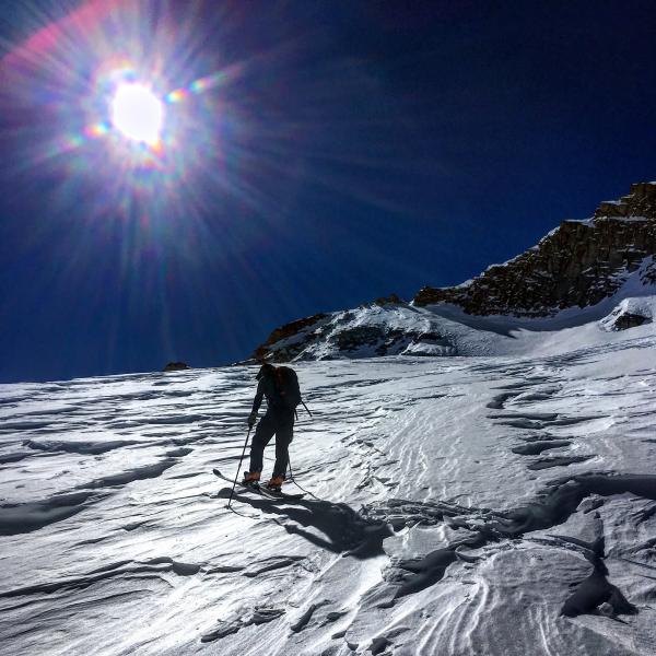
current conditions Temperatures did not drop below freezing last night. Low temperatures only dropped to near 40° F in most places after high temperatures yesterday reached the 50's F. Even at 11,000 feet, low temperatures only reached 37° F. The snowpack has a lot of heat in it from the last few days of very warm weather and strong sunshine. Clear skies may have caused a very thin surface layer to refreeze, but this will break down quickly this morning if it exists at all. Winds this morning shifted to the SW and were blowing 10-20 mph. North facing slopes at high elevations are a mix of "wind crusts, sastrugi, or boiler plate" snow. Photo and observation from White Pine by Mark White.
|
 |
recent activity More wet avalanches occurred in the south facing terrain in Little Cottonwood Canyon including this one across the road from the White Pine Trailhead. Photo by Mark White.
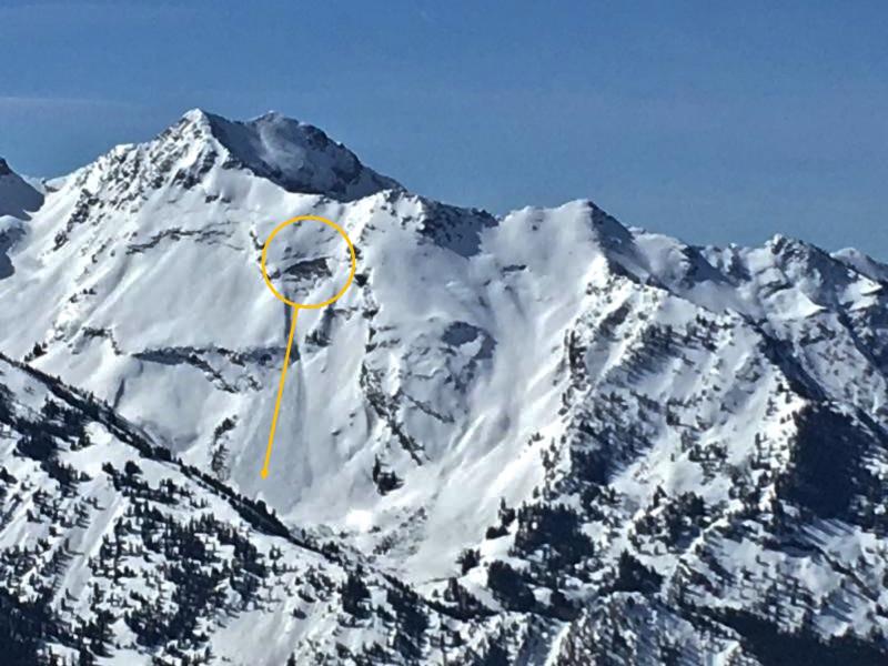
A new glide avalanche was reported in the Blue Ice area of Broads Fork of Big Cottonwood Canyon. The link takes you to the Wasatch Backcountry Skiing map and it's easy to see why so many glides occur in Broads...so much of the northeast facing terrain harbors steep slabs of rock. (zoomed photo by Zimmerman-Wall)
|
| type | aspect/elevation | characteristics |
|---|

|

|
LIKELIHOOD
 LIKELY
UNLIKELY
SIZE
 LARGE
SMALL
TREND
 INCREASING DANGER
SAME
DECREASING DANGER
|
|
description
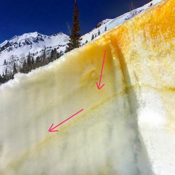
Wet avalanche activity should start to occur earlier today than it did yesterday because of above freezing temperatures overnight. It will not take much additional sunshine this morning to start the melting process and cause wet avalanches. Some wet slab avalanches are possible depending on where and how liquid water percolates though the snowpack. Yesterday in upper Little Cottonwood Canyon on a south facing slope, I would sink to my knees as soon as I stepped out of my skis because the snow was wet several feet deep. What's interesting though is that liquid water was percolating about 10 inches down then moving downslope along an old ice crust (see photo below). How liquid water moves through the snow varies from slope to slope depending on layers in the snowpack and determines avalanche activity. We spread powdered Tang on the snow surface to see where liquid water was moving in the snowpack.
|
| type | aspect/elevation | characteristics |
|---|

|
|
LIKELIHOOD
LIKELY
UNLIKELY
SIZE
 LARGE
SMALL
TREND
 INCREASING DANGER
SAME
DECREASING DANGER
|
|
description
Cornices break unpredictably both in location and timing. However, they are more prone to breaking during hot weather. Avoid being under or on top of these monsters. They can break well beyond the apex of the ridgeline. |
| type | aspect/elevation | characteristics |
|---|
|

|
LIKELIHOOD
 LIKELY
UNLIKELY
SIZE
LARGE
SMALL
TREND
INCREASING DANGER
SAME
DECREASING DANGER
|
|
description
Glide avalanches are just as unpredictable as cornices, but they too are more likely to release during periods of warm weather. Glide cracks are places where the entire snowpack has separated and moved downhill. They tell us where glide avalanches can occur, and it's best to avoid being under any slope showing these deep cracks in the snowpack. Common places for glide avalanches are Stairs Gulch, Broads Fork, and Mill B South of Big Cottonwood Canyon, but they can occur other places. Below is a photo near Wilderness Peak north of Logan just inside Idaho showing glide cracks in the snowpack. Avoid being on or under slopes like this.
|
 |
weather The weather today will be warm and sunny with a ridge of high pressure over Utah this morning. High temperatures will reach the 50's F and likely break into the 60's F at trailheads. SW winds will blow 20-40 mph today and bring more warm air into Utah as the ridge of high pressure moves east.
|
general announcements
|