25th Annual Black Diamond Fall Fundraising Party
Thursday, September 13; 6:00-10:00 PM; Black Diamond Parking Lot
25th Annual Black Diamond Fall Fundraising Party
Thursday, September 13; 6:00-10:00 PM; Black Diamond Parking Lot
| Advisory: Salt Lake Area Mountains | Issued by Mark Staples for Saturday - March 11, 2017 - 6:03am |
|---|

|
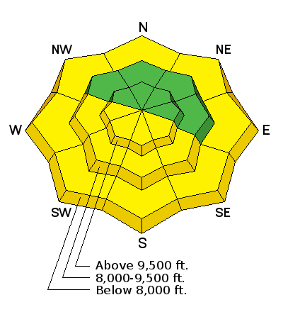
bottom line The avalanche danger will start at LOW this morning on all slopes. As the day warms the danger will rise to MODERATE mostly on the southern half of the compass where loose wet avalanches can occur. Loose wet avalanches are also possible on more northerly facing slopes at low elevations where the snowpack did not refreeze overnight.
|
 |
special announcement Spring Special: We have a few donated Snowbird, Snowbasin, Solitude, and Brighton discount lift tickets left and have just lowered the price. Ski a day and benefit the Utah Avalanche Center! Order here. Guest blogger Tom Diegel follows up with part 2 of The Little Things (that might keep you alive). Check out Part 1 as well for a good discussion about avalanche transceivers. |
 |
current conditions Yesterday air temperatures climbed into the 40's and low 50's F. This morning under clear skies, most areas have temperatures in the high 20's F with temperatures near freezing between 7-8,000 feet. WNW winds are blowing 5 mph gusting to 15. On the high peaks and highest ridgelines winds are blowing 20-30 mph. South aspects should start to have decent corn snow while high elevation north aspects should have soft snow or firm chalky snow. Greg Gagne's Week in Review March 3-9th can be found here. |
 |
recent activity Wet loose avalanches occurred predictably yesterday as warm temperatures and sunshine heated the snow surface |
| type | aspect/elevation | characteristics |
|---|

|
|
LIKELIHOOD
 LIKELY
UNLIKELY
SIZE
 LARGE
SMALL
TREND
 INCREASING DANGER
SAME
DECREASING DANGER
|
|
description
Below freezing air temperature and clear skies helped refreeze the snowpack this morning. The threat of loose wet avalanches will slowly rise as the snow surface warms and melts. The key to avoiding these types of avalanches is timing. Most days the cycle for wet snow goes like this:
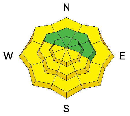
The timing of this cycle varies by slope through the day with East aspects experiencing it first and West aspects experiencing it last. Loose wet avalanches can occur on northerly aspects as well at low elevations or near rock bands and cliffs. |
| type | aspect/elevation | characteristics |
|---|

|
|
LIKELIHOOD
 LIKELY
UNLIKELY
SIZE
 LARGE
SMALL
TREND
 INCREASING DANGER
SAME
DECREASING DANGER
|
|
description
With so much snow this year, winds have formed giant cornices. When and where they break is hard to predict. The best strategy is to avoid being on top of or beneath them. Traveling beneath them is possible but move quickly to limit your exposure. The snowpack slowly creeps downhill and glide cracks open where it rests on a smooth ground surface like big rock slabs. At unpredictable times, a glide avalanche can occur. Seeing these glide cracks is the only indication these avalanches are possible. As with cornices, the best risk management strategy is to avoid being under these places. Glide avalanches mostly occur in the Broads Fork, Stairs Gulch, and Mill B South drainages of Big Cottonwood Canyon |
 |
weather Today will be another warm one with clear sunny skies. Mountain temperatures should easily reach the 40's F and west winds will be light. |
general announcements
|


