25th Annual Black Diamond Fall Fundraising Party
Thursday, September 13; 6:00-10:00 PM; Black Diamond Parking Lot
25th Annual Black Diamond Fall Fundraising Party
Thursday, September 13; 6:00-10:00 PM; Black Diamond Parking Lot
| Advisory: Salt Lake Area Mountains | Issued by Drew Hardesty for Friday - March 10, 2017 - 5:10am |
|---|

|
bottom line Due to a poor overnight refreeze, the danger for wet avalanches will rapidly rise to MODERATE AND PERHAPS CONSIDERABLE for natural and human triggered wet loose sluffs today. All but the high northerly aspects will be prone to wet activity with today's heating. When you see the tell-tale signs of wet avalanche instability, it'll be high time to avoid steep terrain and the runout zones below.
|
 |
special announcement Spring Special: We have a few donated Snowbird, Snowbasin, Solitude, and Brighton discount lift tickets left and have just lowered the price. Ski a day and benefit the Utah Avalanche Center! Order here. The Wasatch Powderkeg will be held Friday and Saturday, Mar 10 and 11, at Brighton as a benefit for the Utah Avalanche Center, featuring a Ski Mountaineering Sprint race on Friday afternoon and a longer race Saturday with Race, recreation, and youth courses and divisions. There will also be Companion Rescue, Terrain Strategies, Split-boarding, Steep Skiing and Riding, and Mountaineering Techniques for Skiers and Snowboarders skills clinics Saturday taught by local pros. There will be a drawing for great gear including boots and winner's choice of skis or a split-board mid-day Saturday. Details here. Guest blogger Tom Diegel follows up with part 2 of The Little Things (that might keep you alive). |
 |
current conditions High clouds portend tonight's blockbuster trace-to-an-inch "storm". Winds are southwesterly, blowing 10-15mph, gusting to 25. Mountain temperatures above, say, 9000', already meet or exceed yesterday's highs in the mid to upper 30s to low 40s. With the heat-trapping thin blanket of clouds and warm temps, the refreeze will be sad and superficial and softening much earlier than yesterday. Riding conditions are myriad sun, wind, rime, and melt-freeze crusts, though yesterday high along the Ogden skyline, I found supportable, consistent snow conditions and 5-star views. Greg Gagne's Week in Review March 3-9th can be found here.
|
 |
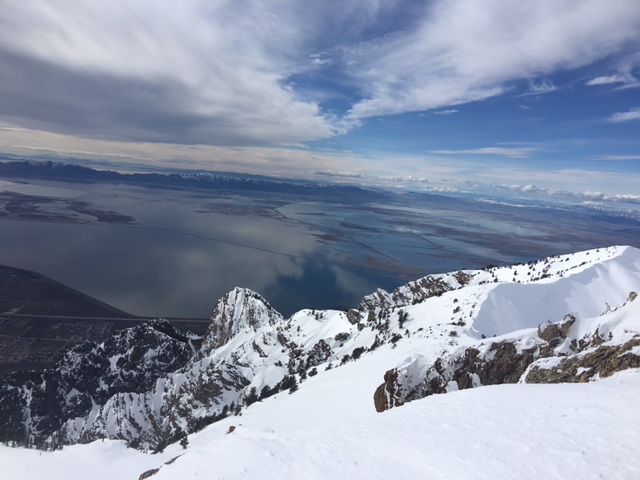
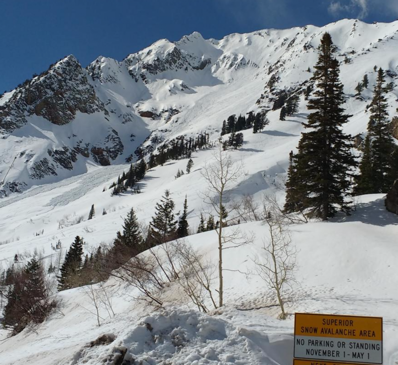
recent activity Avalanche activity yesterday can be attributed directly to direct sun and heating, spiking during the midday to early afternoon hours. East, south, and west facing aspects all naturalled wet loose sluffs big enough to bury a person. (Mt Superior photo, UDOT). Warm ambient temperatures dampened the mid-elevation northerly aspects that resulted in minor rollerballing, so don't be surprised to find a breakable but short-lived melt-freeze crust in this terrain this morning. Mark went up to look at Wednesday's human triggered wind slab in the Cardiac Bowl area and his report is found here.
|
| type | aspect/elevation | characteristics |
|---|

|
|
LIKELIHOOD
 LIKELY
UNLIKELY
SIZE
 LARGE
SMALL
TREND
 INCREASING DANGER
SAME
DECREASING DANGER
|
|
description
With a poor overnight refreeze, the snow will again become wet and sloppy. Any direct sun filtering through the high clouds will further contribute to the deteriorating conditions. Wet loose sluffs will be easy to trigger and it'll be key to watch for the predictable signs - dampening snow, roller balls and small sluffs, often initiating off rocks and cliff bands. With the warmth and cloud cover (perhaps even some green-housing), the snow on mid and low elevation northerly facing slopes will also get damp and sluff today as well. |
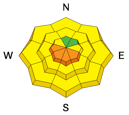
| type | aspect/elevation | characteristics |
|---|

|
|
LIKELIHOOD
LIKELY
UNLIKELY
SIZE
 LARGE
SMALL
TREND
 INCREASING DANGER
SAME
DECREASING DANGER
|
|
description
Enormous cornices along the ridge lines and opening glide cracks are encouraged to release with warm temperatures. Avoidance is the key - stay way back from the edges of the cornices and minimize any time spent traveling beneath them. The neighborhoods where glide avalanches occur are primarily located in Big Cottonwood Canyon and include Broads Fork, Stairs Gulch, and Mill B South. |
 |
weather We'll have increasing clouds and moderate west to southwest winds ahead of tonight's weak disturbance. But it's not like a hard rain's gonna fall - we might only see a trace to an inch of snow. I'm pulling for no precipitation as the rain/snow line will hover around 8000' or so. Today's highs will reach to the upper 30s at 10,000' and the low 50s at 8000'. Slightly cooler air accompanies the weak cold front tonight, but it'll be back to spring weather again on Saturday. Another weak disturbance arrives Sunday morning. Cooler temps and stronger winds accompany this wave, but precipitation amounts should be about the same. High pressure rebuilds for early week. |
general announcements
|