25th Annual Black Diamond Fall Fundraising Party
Thursday, September 13; 6:00-10:00 PM; Black Diamond Parking Lot
25th Annual Black Diamond Fall Fundraising Party
Thursday, September 13; 6:00-10:00 PM; Black Diamond Parking Lot
| Advisory: Salt Lake Area Mountains | Issued by Evelyn Lees for Thursday - March 9, 2017 - 6:17am |
|---|


|
bottom line This morning: the avalanche danger is generally LOW, with a MODERATE danger at the upper elevations for triggering dense wind drifts that could take you for a ride. By late morning through the day: the avalanche danger will rise to MODERATE and then CONSIDERABLE for wet loose sluffs, first on east then south then west facing slopes and on all low and mid elevation slopes. Natural wet loose avalanches will occur - avoid steep sunny slopes and the run out zones below - like the bottoms of gullies and avalanche paths.
|
 |
special announcement LCC Backcountry Closure: 10pm 3/8 to 8am 3/9 Lisa Falls to Superior for weapons testing Thursday morning. Two Trees to Grizzly Gulch open as is south side accessed from White Pine parking. Tonight - Thursday 3/9 6:00 PM - This week the Utah Adventure Journal Speaker Series hosts Joe Grant. Last summer Joe did a self-powered link up of all of Colorado's 14,000ft peaks by bike and on foot. Starting at his home Joe rode more than 1,100 miles, ran/hiked more than 400 miles and summited 57 peaks all in 1 month. Joe will share the story of his adventure, the highs and lows, the gear, the logistics, and style he used to overcome the challenges of Colorado's high country. You can find more information about the presentation here. Spring Special: We have a few donated Snowbird, Snowbasin, Solitude, and Brighton discount lift tickets left and have just lowered the price. Ski a day and benefit the Utah Avalanche Center! Order here. The Wasatch Powderkeg will be held Friday and Saturday, Mar 10 and 11, at Brighton as a benefit for the Utah Avalanche Center, featuring a Ski Mountaineering Sprint race on Friday afternoon and a longer race Saturday with Race, recreation, and youth courses and divisions. There will also be Companion Rescue, Terrain Strategies, Splitboarding, Steep Skiing and Riding, and Mountaineering Techniques for Skiers and Snowboarders skills clinics Saturday taught by local pros. There will be a drawing for great gear including boots and winner's choice of skis or a splitboard mid-day Saturday. Details here. |
 |
current conditions Under mostly clear skies, temperatures this morning are above freezing at the mid elevations, and in the 20s at the upper elevations and in the canyon bottoms where cold air has pooled. The southwesterly winds peaked overnight at 10,000’, and are decreasing this morning – now averaging 10 to 15 mph. The highest peaks are averaging 35 mph. The snow surface is “variable”, with the last of the cold, dry snow to be found on upper elevation north and northeasterly facing slopes, dotted with punchy wind slabs. The widespread breakable sun crusts at the lower elevations and on sunny slopes will soften later today, into thick sloppy snow. |
 |
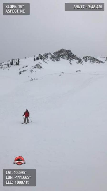
recent activity Yesterday, avalanche activity in the backcountry was a mix of wet and dry. There were 2 large wet loose sluffs mid Canyon in Little Cottonwood, in steep south facing gullies, with more numerous small wet loose sluffs at the lower elevations. A surprisingly large wind slab was triggered on the north facing approach to Cardiac Bowl – about 150’ wide. Resort control work also triggered small to medium sized wind slabs at the upper elevations. Cardiff Fork wind slab
|
| type | aspect/elevation | characteristics |
|---|

|
|
LIKELIHOOD
 LIKELY
UNLIKELY
SIZE
 LARGE
SMALL
TREND
 INCREASING DANGER
SAME
DECREASING DANGER
|
|
description
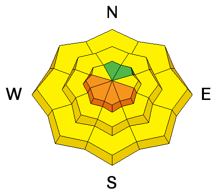
Heats on – with more sun and warmer temperatures today, the snow will rapidly become wet and sloppy. Wet loose sluffs will be easy to trigger, and predictable natural wet loose avalanches are expected. Avalanches will start first on east facing slopes, then south then west. Slides may be larger and run further than expected as they entrain snow on their downward journey. Watch for the predictable signs - dampening snow, roller balls and small sluffs, often initiating off rocks and cliff bands. These mean it’s time to head to lower angle slopes or a different cooler aspect. The snow on mid and low elevation northerly facing slopes will also get damp and sluff today. |
| type | aspect/elevation | characteristics |
|---|

|
|
LIKELIHOOD
 LIKELY
UNLIKELY
SIZE
 LARGE
SMALL
TREND
 INCREASING DANGER
SAME
DECREASING DANGER
|
|
description
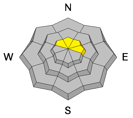
Wind slabs can still be triggered on upper elevation slopes facing northwest, north and northeast. Most are small and stubborn or not reactive, but yesterday’s slide shows there are a few larger deposits of wind-drifted snow that can be triggered. The wind slabs are scattered from the ridge lines all the way down into the drainage bottoms. Terrain matters - getting caught above cliffs, trees or on a continuously long, steep slope will have more serious consequences |
| type | aspect/elevation | characteristics |
|---|

|
|
LIKELIHOOD
LIKELY
UNLIKELY
SIZE
LARGE
SMALL
TREND
INCREASING DANGER
SAME
DECREASING DANGER
|
|
description
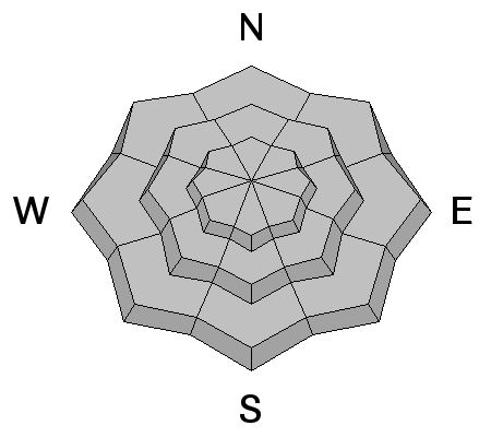
Enormous cornices along the ridge lines and opening glide cracks are encouraged to release with warm temperatures. It would be just like the night to play tricks – these unpredictable avalanches release around the clock. Avoidance is the key - stay way back from the edges of the cornices and minimize any time spent beneath either. The neighborhoods where glide avalanches occur are primarily located in Big Cottonwood Canyon and include Broads Fork, Stairs Gulch, and Mill B South. |
 |
weather With warm temperatures and no major storms in the 10-day forecast, we could be headed toward a possible corn cycle and decent mountaineering conditions once overnight temperatures cool. Today, under mostly clear skies, highs will reach freezing at 10,000’, and close to 50 at 8000’. The southwesterly winds are decreasing, should average less than 10 mph at most stations, with the highest peaks averaging 20 mph. Tomorrow, warm and sunny in the morning, with increasing clouds in the afternoon. Two small systems, one late Friday and another Sunday, will bring brief, minor cooling. Then a major warm up next week, with 10,000’ temperatures soaring into the upper 30s by Tuesday. No major storms in the 10 day forecast. |
general announcements
|