25th Annual Black Diamond Fall Fundraising Party
Thursday, September 13; 6:00-10:00 PM; Black Diamond Parking Lot
25th Annual Black Diamond Fall Fundraising Party
Thursday, September 13; 6:00-10:00 PM; Black Diamond Parking Lot
| Advisory: Salt Lake Area Mountains | Issued by Evelyn Lees for Wednesday - March 8, 2017 - 6:48am |
|---|

|
bottom line This morning: the avalanche danger is generally LOW, with a MODERATE danger at the upper elevations for triggering small, dense wind drifts that could take you for a ride. By late morning through the day: the avalanche danger could rise to MODERATE for wet loose sluffs if and when the sun comes out, first on east then south then west facing slopes and on all low elevation slopes.
|
 |
special announcement Spring Special: We have a few donated Snowbird, Snowbasin, Solitude, and Brighton discount lift tickets left and have just lowered the price. Ski a day and benefit the Utah Avalanche Center! Order here. The Wasatch Powderkeg will be held Friday and Saturday, Mar 10 and 11, at Brighton as a benefit for the Utah Avalanche Center, featuring a Ski Mountaineering Sprint race on Friday afternoon and a longer race Saturday with Race, recreation, and youth courses and divisions. There will also be Companion Rescue, Terrain Strategies, Splitboarding, Steep Skiing and Riding, and Mountaineering Techniques for Skiers and Snowboarders skills clinics Saturday taught by local pros. There will be a drawing for great gear including boots and winner's choice of skis or a splitboard mid-day Saturday. Details here. |
 |
current conditions It’s transition day from winter back to spring. Under mostly cloudy skies, temperatures this morning are about 15 degrees warmer than yesterday morning - in the mid 20s to low 30s. At the 9,000’ and 10,000’ stations, the southwesterly winds are averaging 15 to 20 mph, with gusts to 30. The highest peaks are gusting into the 40s. There is a patina of sun crusts on south and west facing slopes this morning, and widespread erratic dense wind drifts scattered from the ridge lines all the way down into the basin bottoms. For soft snow, look for more wind sheltered terrain or treed slopes. |
 |
recent activity Yesterday, several wind slabs were triggered – a narrow, but long running slide on south facing Superior, and a small one in Hide-a-way Park, about 12” deep by 15’ wide, on a northeasterly facing slope. The resorts, with larger triggers, released hard wind slabs up to 1 ½ to 2 feet deep along high ridge lines, many of which had an easterly facing component. Left - Hide-a-way Park Right - Brighton perimeter
|
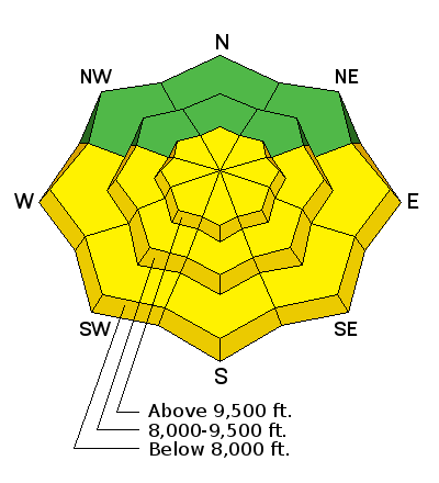
| type | aspect/elevation | characteristics |
|---|

|
|
LIKELIHOOD
 LIKELY
UNLIKELY
SIZE
 LARGE
SMALL
TREND
 INCREASING DANGER
SAME
DECREASING DANGER
|
|
description
Wind slabs are scattered just about everywhere. Generally hard, small and not very reactive, many were cracking but not moving yesterday. But both backcountry and resort activity indicates there are places where you could trigger on, so avoid getting tripped up in the wrong place – don’t get caught above cliffs, trees or on a continuously long, steep slope where consequences are more serious. Typical wind slab cracking out. Photo by Andrew.
|
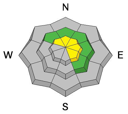
| type | aspect/elevation | characteristics |
|---|

|

|
LIKELIHOOD
LIKELY
UNLIKELY
SIZE
LARGE
SMALL
TREND
 INCREASING DANGER
SAME
DECREASING DANGER
|
|
description
Warming temperatures and the forecast mix of clear skies and thin clouds should heat the snow on many aspects today. The snow on sunny slopes – first east then south then west – will become damp, and it will be possible to trigger wet loose sluffs. A few may run further than expected if they go down to the old ice crusts and entrain snow on their downward journey. Watch for the predictable signs - dampening snow, roller balls and small sluffs, often initiating off rocks and cliff bands. These mean it’s time to head to lower angle slopes or a different cooler aspect. Northerly low and mid elevation snow may also get damp and sluffy today during periods of high thin clouds. |
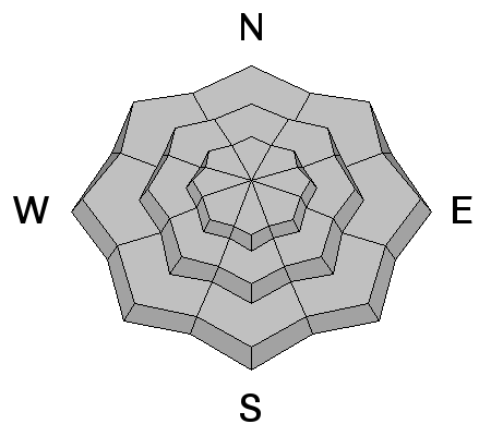
| type | aspect/elevation | characteristics |
|---|

|
|
LIKELIHOOD
LIKELY
UNLIKELY
SIZE
LARGE
SMALL
TREND
INCREASING DANGER
SAME
DECREASING DANGER
|
|
description
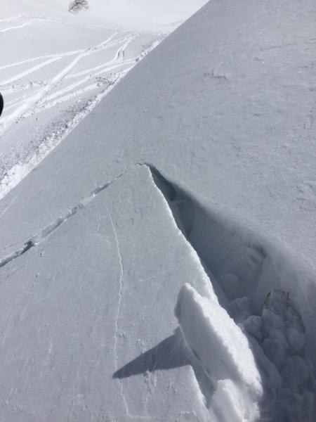
The idiot wind, blowing through the buttons of our coats all winter, has left enormous cornices along the ridge lines. Avoidance is the key - stay way back from the edges and avoid travel below them – if one drops off above you, it could trigger a slide or you could be squashed by one of the huge blocks. Glide avalanches – Glide avalanches can occur day or night, and warm weather does seem to encourage them to occur. The neighborhoods where glide avalanches occur are primarily located in Big Cottonwood Canyon and include Broads Fork, Stairs Gulch, and Mill B South |
 |
weather A mild, westerly flow will be over the region for the next few days. We’re just on the southern edge of the jet stream today, and small waves will bring clouds and occasional very light snow to the mountains, especially north of I-80. 8000’ temperatures will warm into the low to mid 40s today, with 10,000’ temperatures warming slightly into the mid 20s. Southwesterly winds will be in the 5 to 15 mph range, gusting to 25 mph. Across the highest peaks, speeds are a bit brisker, and could average to 30 at times, with gusts in the 40s. Tomorrow will be even warmer and sunnier. |
general announcements
|