25th Annual Black Diamond Fall Fundraising Party
Thursday, September 13; 6:00-10:00 PM; Black Diamond Parking Lot
25th Annual Black Diamond Fall Fundraising Party
Thursday, September 13; 6:00-10:00 PM; Black Diamond Parking Lot
| Advisory: Salt Lake Area Mountains | Issued by Drew Hardesty for Thursday - March 2, 2017 - 5:11am |
|---|

|
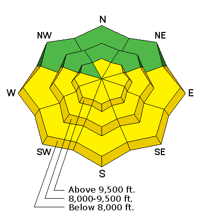
bottom line The avalanche danger will rise to the high end of MODERATE on all steep sunlit slopes with daytime warming. The steep east to south to west facing terrain is to be avoided by the time it becomes damp and unstable, usually in the mid-morning to mid-afternoon hours. Pockets of MODERATE exist for lingering wind drifts in the steep exposed alpine terrain. Cornices have become gargantuan and unruly - take particular care along and beneath cornice-littered ridgelines.
|
 |
special announcement Little Cottonwood Canyon Backcountry Closure: LCC Lisa Falls-Superior 4:00am to 1:00pm UDOT will be sighting-in their mid-canyon weapon in LCC Thursday morning. Estimated opening is 1pm. Please stay clear of the north side of the road from Lisa Falls to Superior. Little Superior through Grizzly Gulch Open. New guest blog by Tom Diegel - The Little Things (that might keep you alive) - Part I Tonight - Thursday 3/2 6pm The Utah Adventure Journal Speaker Series hosts professional ski-mountaineer Noah Howell. He'll be sharing photos and video from three unique mountain adventures: a first descent on the iconic Moose's Tooth in the Alaska Range, the classic Hardrock 100 in Colorado on skimo gear and deep powder gluttony in the Wasatch Mountains. For more info, click here. These events also support the Utah Avalanche Center. |
 |
current conditions Skies are clear. Winds are west to northwesterly, blowing 10-15mph. Mountain temperatures are in the single digits at the trailheads and the low teens along the ridgelines. Riding conditions are 4 star (out of 5) and coverage is excellent. Look for a new crop of surface hoar feathers shimmering in the light above yesterday's snow surface. Some south and westerly aspects will sport a breakable crust this morning that will soften with daytime warming. I spoke with Mark Saurer this morning. He's part of the UDOT avalanche team in Little Cottonwood Canyon that has been keeping weather records since 1944/1945. Their office is on the north side of the street at the Alta Guard, there above Our Lady of the Snows. Mark indicated that February's snow totals were 114" with 9" of snow-water-equivalent, easily besting the 72 year average of 81.4" and 7.30" (SWE). It's our 8th snowiest February on record. This season, the Alta Guard has tallied 413" - the first time we've topped 400" for a full season since 2010-11. I consider Mark to be a good friend and one of the more thoughtful snow people in the business. Read up on a couple of his interesting avalanche papers on stream flow and wet avalanches here....and the use of thermal imagery to detect recent avalanches and, not coincidentally, people in their intended starting zones targeted for artillery shoot. A good piece of history on the early years at Alta can be found here.
|
 |
recent activity Avalanche activity peaked overnight Tuesday into early Wednesday along with the moderate to strong gusty winds as observers noted a few natural wind slabs 12-18" deep in the high alpine. Conditions rapidly stabilized as skiers and riders tested many steep slopes without incident. |
| type | aspect/elevation | characteristics |
|---|

|
|
LIKELIHOOD
 LIKELY
UNLIKELY
SIZE
 LARGE
SMALL
TREND
 INCREASING DANGER
SAME
DECREASING DANGER
|
|
description
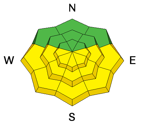
Direct sun and warming will conspire to dampen and loosen the snow on the steep sunlit aspects today. Rollerballs and natural sluffs are key indicators that the snow is becoming saturated and unstable. The most problematic situation will be in the mid-morning to afternoon hours in the steepest, most confined terrain where enough loose wet snow may gouge down to Sunday's slick melt-freeze crust and entrain significant amounts of snow. These steep sun-drenched slopes should become active over the next few days... Know that avoidance of wet avalanche issues come down to place and time. For example - enjoy the east facing terrain in the early morning and then move to other, cooler aspects before they heat up. As with most things in life, timing is everything. |
| type | aspect/elevation | characteristics |
|---|

|
|
LIKELIHOOD
 LIKELY
UNLIKELY
SIZE
LARGE
SMALL
TREND
 INCREASING DANGER
SAME
DECREASING DANGER
|
|
description
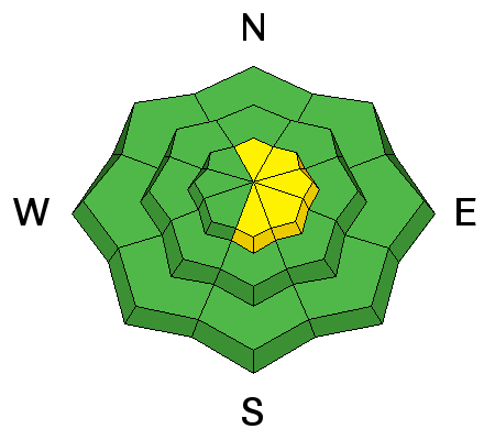
Lingering, isolated pockets of wind slab may be still be triggered in steep locations in the alpine, particularly after they've enjoyed the direct sun and rapid warming. These pockets may be 12-20" deep and predominantly found on north to east to south facing slopes. |
| type | aspect/elevation | characteristics |
|---|

|
|
LIKELIHOOD
LIKELY
UNLIKELY
SIZE
 LARGE
SMALL
TREND
INCREASING DANGER
SAME
DECREASING DANGER
|
|
description
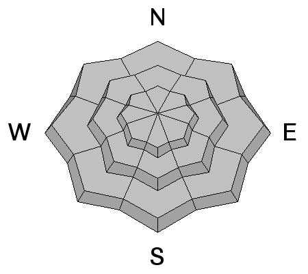
Cornices are enormous. They may break off on approach and break back well beyond the apex of the ridgeline. Longtime observer Brian Smith in Ogden said it best - "it is difficult to tell where the earth ends and the snow begins." Avoid being on or beneath these gigantic whales of snow. |
 |
weather We'll have mostly sunny skies, light westerly winds and daytime highs reaching to near 40°F at 8500'. 10,000' will reach just beyond 20°F. The warming trend will continue into the weekend with the next storm system slated for later Sunday into Monday. |
general announcements
|


