25th Annual Black Diamond Fall Fundraising Party
Thursday, September 13; 6:00-10:00 PM; Black Diamond Parking Lot
25th Annual Black Diamond Fall Fundraising Party
Thursday, September 13; 6:00-10:00 PM; Black Diamond Parking Lot
| Advisory: Salt Lake Area Mountains | Issued by Drew Hardesty for Wednesday - March 1, 2017 - 5:18am |
|---|

|
bottom line The avalanche danger is CONSIDERABLE for wind drifts at the mid and upper elevations. Human triggered avalanches are probable and most pronounced on steep north to east to south facing slopes...though terrain channeling of the winds will make many aspects suspect, particularly off the exposed ridgelines. Careful snowpack evaluation, cautious route-finding and conservative decision-making will be essential today.
|
 |
special announcement New guest blog by Tom Diegel - The Little Things (that might keep you alive) - Part I Tomorrow night - Thursday 3/2 6pm This week the Utah Adventure Journal Speaker Series hosts professional ski-mountaineer Noah Howell. He'll be sharing photos and video from three unique mountain adventures: a first descent on the iconic Moose's Tooth in the Alaska Range, the classic Hardrock 100 in Colorado on skimo gear and deep powder gluttony in the Wasatch Mountains. For more info, click here. These events also support the Utah Avalanche Center. |
 |
current conditions Just putting the finishing touches on the current storm system...and skies are trending mostly cloudy. Mountain temperatures are in the single digits. Winds, however, play the spoiler. Overnight west-northwest winds blew 25-30mph with gusts to 45. 11,000' winds averaged 50-55mph with gusts to 70. They've lost some steam the last couple of hours, but the damage is irreconcilably done. Overnight snowfall amounts are 2-4" in the upper Cottonwoods and along the Park City ridgeline, pushing storm totals since early Monday to 20-26"" in the upper Cottonwoods and 16-20" along the PC ridge. It's been an amazing year and overall coverage is excellent. Snow totals on the ground above 9500' are 120-150". |
 |
recent activity Reported avalanche activity yesterday was minor in scope, with loose snow sluffing and isolated wind slabs to 20" deep in very exposed terrain. A few cornices along the exposed ridgelines became unhinged and triggered either shallow drifts or minor dry sluffs. |
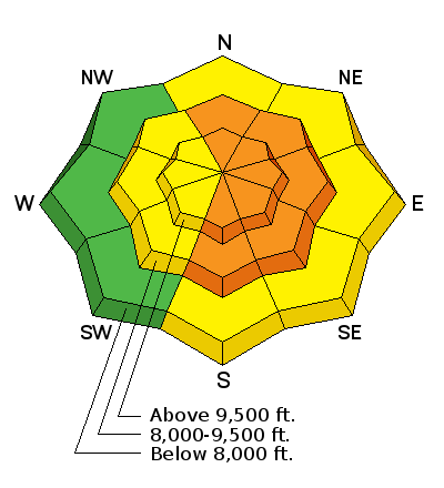
| type | aspect/elevation | characteristics |
|---|

|
|
LIKELIHOOD
 LIKELY
UNLIKELY
SIZE
 LARGE
SMALL
TREND
 INCREASING DANGER
SAME
DECREASING DANGER
|
|
description
Pro observer Tyler Falk encountered wind drifts up to 20" deep in the upper reaches of Hogum Fork of Little Cottonwood Canyon yesterday. These drifts were more the exception than the rule. Today, expect drifts like these to be the rule and not the exception. Wind drifts are often smooth and rounded, stiff and chalky. You'll instantly notice that it's not the world-class blower powder anymore if you transition to wind drifted terrain. Even the mid-elevation anemometers couldn't hide from the wind. Drifts may exceed two feet in heavily drifted terrain, with drifts likely well off the ridgelines and cross-loaded beyond sub-ridges and rocky outcrops. They'll need a couple days to stabilize. Consider shooting cracks and audible collapsing of wind pillows to be sure signs of instability. |
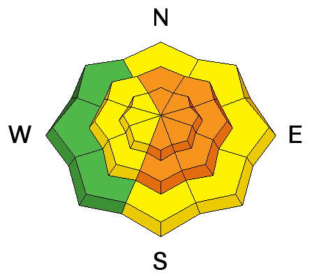
| type | aspect/elevation | characteristics |
|---|

|

|
LIKELIHOOD
 LIKELY
UNLIKELY
SIZE
 LARGE
SMALL
TREND
 INCREASING DANGER
SAME
DECREASING DANGER
|
|
description
A couple of notes for today -
|
| type | aspect/elevation | characteristics |
|---|

|
|
LIKELIHOOD
LIKELY
UNLIKELY
SIZE
 LARGE
SMALL
TREND
INCREASING DANGER
SAME
DECREASING DANGER
|
|
description
Cornices are enormous. They may break off on approach and break back well beyond the apex of the ridgeline. Longtime observer Brian Smith in Ogden said it best - "it is difficult to tell where the earth ends and the snow begins." Avoid being on or beneath these gigantic whales of snow. |
 |
weather Skies will continue to trend partly cloudy in the wake of the storm. 8000' and 10,000' temps will be in the low twenties to low teens, respectively. West to northwest winds will blow 15-20mph with gusts to 30. Skies will start to clear overnight as weak high pressure builds into the area over the next few days. The next storm system arrives Sunday. Details to follow. |
general announcements
|


