25th Annual Black Diamond Fall Fundraising Party
Thursday, September 13; 6:00-10:00 PM; Black Diamond Parking Lot
25th Annual Black Diamond Fall Fundraising Party
Thursday, September 13; 6:00-10:00 PM; Black Diamond Parking Lot
| Advisory: Salt Lake Area Mountains | Issued by Greg Gagne for Friday - February 24, 2017 - 5:22am |
|---|

|
bottom line The avalanche hazard is CONSIDERABLE today for loose, dry sluffs in steeper terrain, and for fresh wind drifts at the upper elevations. Brilliant, license-plate worthy powder skiing can safely be enjoyed today on lower-angled slopes.
|
 |
special announcement Little Cottonwood Canyon Backcountry Closure: LCC Full Closure North Side Thursday, February 23, 2017 - 10:00pm to Friday, February 24, 2017 - 8:00am Full north-side LCC backountry closure from Lisa Falls through Grizzly Gulch. South-side access from White Pine parking ok. Estimated opening when LCC road opens approximately 8am Friday the 24th. Click here for more details. |
 |
current conditions As of 5 am, mountain temperatures range throughout the single digits and winds are out of the west/northwest. Winds increased for a few hours overnight, but are currently averaging < 10 mph with gusts in the teens at 10000'. Above 10,000' winds are averaging in the teens with gusts in the 20's mph, although gusts have been a high as 40 mph at 11,000'. The Cottonwoods and Park City mountains picked up another 5-7" of 3-5% fluff overnight, with 24 hour totals of 18". The Week in Review summarizes snow totals for the past week. Despite the low-density fluff, trailbreaking was a chore on Thursday, and thigh-deep in places. Settlement overnight and during the day today should help reduce the struggle of uphill - and occasional downhill - trailbreaking. Week in Review A series of weather systems on a southwest flow arrived over Friday through Sunday Feb 17/18/19 with storm totals of up to 24" in the Cottonwoods, 14" in the Park City mountains, 18" Ogden mountains, and 6" at the mid elevations in the Provo mountains. Storm densities were Cascade-like with water totals exceeding 2". Sunday was an especially active day with several skier-triggered avalanches reported from the backcountry. These slides included both storm snow as well as fresh wind slabs, and were running within the storm snow as well as a layer of faceted snow that formed Feb 12-15 during a period of clear high pressure. Monday and Tuesday featured warming temperatures, with increasingly strong winds that gusted over 60 mph by Tuesday afternoon. These strong winds ushered in a cold front that arrived Tuesday evening. A cold, unstable northwest flow led to continued moderate to strong snowfall since Tuesday evening, with impressive storm totals:
Avalanche activity during this storm included wind drifts primarily at the upper elevations and long-running sluffs in the loose dry snow and resulted from control work at the resorts and the mountain highways, as well as natural activity that occurred during spikes in precipitation. During this period, the avalanche hazard was either Moderate or Considerable, but with brief spikes to High during periods of heavy precipitation. |
 |
recent activity Small to medium-sized slides were reported from control work at the resorts as well as highways on Thursday, and a few small natural avalanches were reported overnight. Late yesterday afternoon a large (class 3) natural avalanche was reported from Mount Superior in Little Cottonwood Canyon. Reports from the backcountry indicated sensitive storm snow during spikes in precipitation, with a likely natural cycle occurring in the late morning, although poor visibility limited avalanche viewing. Pro observer Mark White was able to trigger a soft slab avalanche in West Monitor Bowl along the Park City ridgeline. You can read Mark's usual excellent write-up here.
|
| type | aspect/elevation | characteristics |
|---|

|
|
LIKELIHOOD
 LIKELY
UNLIKELY
SIZE
 LARGE
SMALL
TREND
 INCREASING DANGER
SAME
DECREASING DANGER
|
|
description
Although I am expecting the storm snow to be much less sensitive today, continued snowfall during the day will maintain the likelihood of sluffing in steeper terrain. These sluffs are requiring terrain steeper than 35 degrees, but will run long distances on steep, sustained pitches, entraining snow amounts that are large enough to bury a person. On slopes less steep than 35 degrees, sluffs are difficult to initiate and maintain. On smaller slopes, be sure to avoid where a sluff may take you into a terrain trap such as a steep-sided gully, tree well, or the uphill side of trees where a sluff may pile up deeply enough to bury you. The take home message is that there is abundant terrain where you can safely enjoy our legendary Utah powder by sticking to lower-angled slopes. |
| type | aspect/elevation | characteristics |
|---|

|

|
LIKELIHOOD
LIKELY
UNLIKELY
SIZE
LARGE
SMALL
TREND
 INCREASING DANGER
SAME
DECREASING DANGER
|
|
description
Although winds have fortunately only been in the moderate category, there is an abundance of loose snow available for transport, and any fresh wind drifts will be sensitive. There was a brief increase in winds overnight at some remote weather stations, and any fresh drifts that formed overnight will now be covered by fresh storm snow. I am suspicious and suspect that the natural avalanche that occurred on Mt. Superior late in the day on Thursday was wind-related. Winds are not forecasted to be all that strong today, and concerns for fresh drifts are primarily at elevations above 10,000'. However, winds can be localized so it may be windy where you are. Pay careful attention for any increase in wind speeds and avoid slopes with any recent wind drifting. |
| type | aspect/elevation | characteristics |
|---|

|
|
LIKELIHOOD
LIKELY
UNLIKELY
SIZE
 LARGE
SMALL
TREND
INCREASING DANGER
SAME
DECREASING DANGER
|
|
description
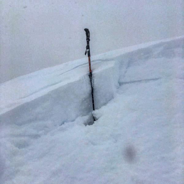
Cornices are immense this season, among the largest I have ever seen in the Wasatch. Any wind drifting along the ridgelines only adds another layer of skin to these monsters. On Wednesday a large avalanche was triggered by a cornice fall, and yesterday I was able to remotely trigger a fresh cornice while walking along a wind-drifted ridgeline: Stay well-back from corniced ridge lines. |
 |
weather Today will be a beautiful winter day with pleasantly cool temperatures, cloudy skies, and with a cold, unstable, northwest flow* continued snow showers that may add up to 3-6". Winds are forecasted to be out of the west/northwest and average about 10 mph at mid elevations, and low 20's at the upper elevations, with temperatures rising into the teens. Continued light to moderate winds overnight with temperatures just above 0 F. Saturday should remain cool and cloudy with snow showers later in the day. A copy-cat cold storm forecasted for early this coming week. * With apologies to Henry James, the most beautiful words in the English language. |
general announcements
|


.JPG)