25th Annual Black Diamond Fall Fundraising Party
Thursday, September 13; 6:00-10:00 PM; Black Diamond Parking Lot
25th Annual Black Diamond Fall Fundraising Party
Thursday, September 13; 6:00-10:00 PM; Black Diamond Parking Lot
| Advisory: Salt Lake Area Mountains | Issued by Drew Hardesty for Thursday - February 23, 2017 - 5:30am |
|---|

|
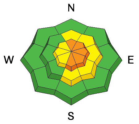
bottom line The danger is CONSIDERABLE today for soft wind drifts and all-but-certain long running sluffs in the low density snow. These will be big enough to catch, carry, and bury a person today. The danger may spike to HIGH during periods of high snowfall rates or if the winds become unreasonable and gusty. Remember that avalanche terrain includes runout zones beneath steep terrain. HOT TIP! - 5% density snow is still world class on low angle slopes.
|
 |
special announcement Little Cottonwood Canyon Backcountry Closures in Effect This Morning
|
 |
current conditions It's like the days of old. Temps are in the upper single digits. Winds, mercifully, are generally light (<15mph) from the west. Overnight and storm totals (snow/snow-water-equivalent) LCC: 10"/0.52" with storm totals thus far - 28"/2.25" BCC: 8"/0.4" with storm totals thus far - 21"/1.60" PC: 8"/0.4" with storm totals thus far - 21"/1.70" It's cold smoke - 5% density snow that's right-side-up. It's the stuff that dreams are made of. |
 |
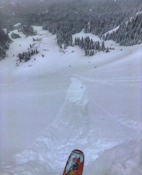
recent activity Yesterday's activity can be described as what was the rule and what was the exception. The Rule: Widespread and commonplace yesterday Avalanche activity within the new snow was most pronounced in the morning although widespread human triggered sluffing continued throughout the day. In the evening hours, a bump in snowfall intensity led to another round of natural long running sluffs in the steeper, more sustained terrain of the Cottonwoods. (Mark White photo)
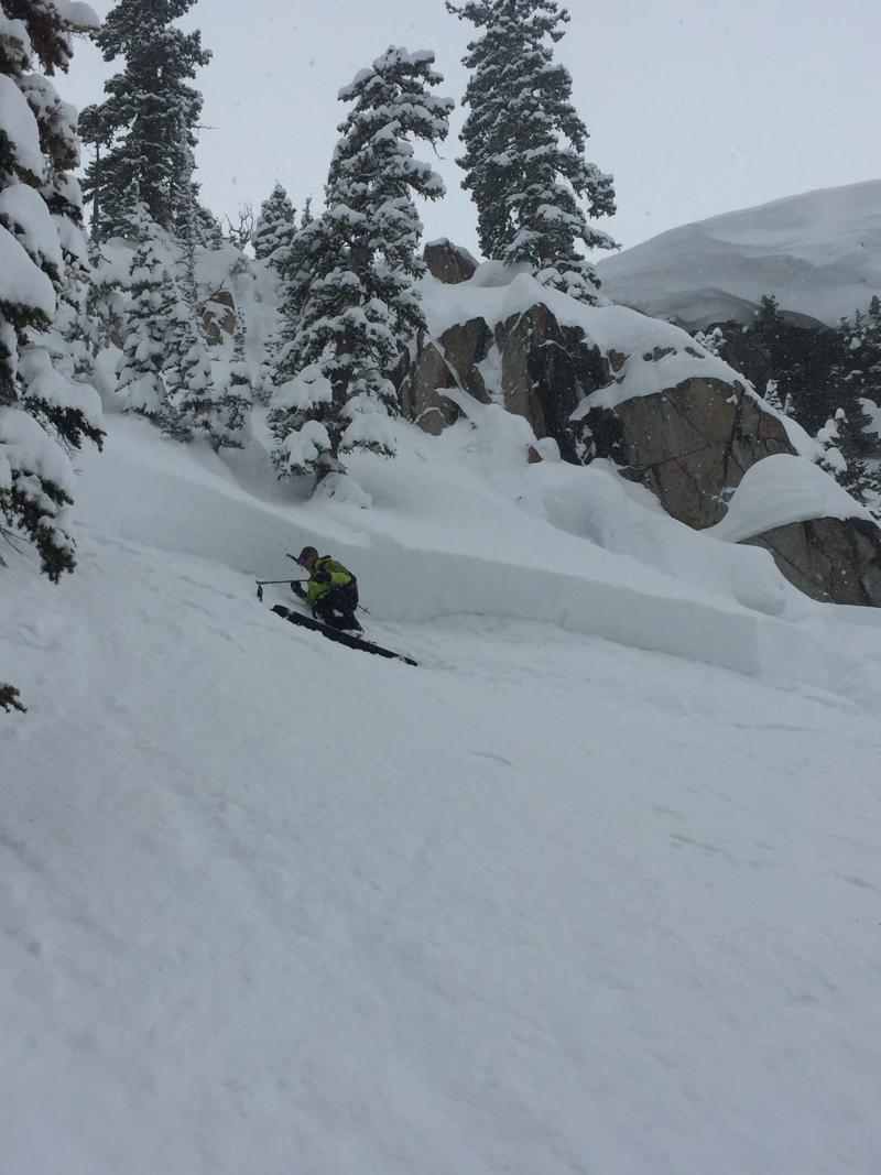
The Exceptions: Isolated and requiring a significant trigger in steep rocky terrain Two very large cornice fall events in the Brighton periphery crow-barred out pockets of snow 2-3' deep and up to 150' wide. The first, reported in Old Reliable, involved a natural cornice fall that pulled out a 3' deep hard slab on a very steep and rocky north facing slope at 10,300' (Stowe photo below/left). The second was a significant event and close call. A snowboarder walking with snowboard in hand triggered and went over with a very large cornice also in the Brighton periphery. This in turn, triggered a 3' deep and 150' wide avalanche on the steep north facing slope below (roughly 9300' in elevation). The snowboarder apparently walked away unharmed. Bruce Engelhard's excellent write up can be found here. His photo below on the right.
|
| type | aspect/elevation | characteristics |
|---|

|
|
LIKELIHOOD
 LIKELY
UNLIKELY
SIZE
 LARGE
SMALL
TREND
 INCREASING DANGER
SAME
DECREASING DANGER
|
|
description
Sensitive, long running point release sluffs will run both naturally and with provocation on steep slopes of all aspects today. Sluffs, as opposed to slab avalanches, start at a point and fan out, gaining momentum while entraining more loose snow while cascading down the slope. They tend to require steeper slope angles to run (approaching 40° and steeper). Today's sluffs will be big enough to catch and carry a person and bury them in the deposition zone below. *These will run naturally today during periods of higher snowfall intensity. Avoid being in runout zones where naturals or human-triggered slides can engulf you. |
| type | aspect/elevation | characteristics |
|---|

|
|
LIKELIHOOD
 LIKELY
UNLIKELY
SIZE
LARGE
SMALL
TREND
 INCREASING DANGER
SAME
DECREASING DANGER
|
|
description
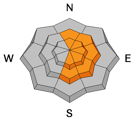
The westerly winds spiked to 15-20mph with gusts to 30mph for a few hours around dinner time last night. These wind slabs are now buried under 6-12" of fluff and may still be triggered on steep north to east to south facing slopes in typically wind exposed terrain. Current wind speeds (gusts to 30+) at 10,500' and 11,000' are enough to transport the low density snow in localized upper elevation terrain and should be on your radar. |
| type | aspect/elevation | characteristics |
|---|

|
|
LIKELIHOOD
LIKELY
UNLIKELY
SIZE
 LARGE
SMALL
TREND
 INCREASING DANGER
SAME
DECREASING DANGER
|
|
description
The ever growing cornices will continue to be a significant concern for those traveling along or underneath ridgelines today. It would be a mistake to encroach onto the larger, more concealed cornices to drop a new soft cornice. As shown, these significant triggers may be enough to pull out storm snow down to the February 10th rain crust, resulting in a more dangerous avalanche. |
 |
weather A cold, unstable west to northwest flow will keep off and on snow showers throughout the day. Watch for periods of higher snowfall rates or occasionally gusty west winds above 10,000'. Temps will continue dropping toward 0°F along the high ridges. It's likely we'll pick up another 6-12" through tonight with snow showers likely tomorrow as well. Another weak storm on tap for later Saturday and another one later Sunday into early week. |
| general announcements Remember your information can save lives. If you see anything we should know about, please help us out by submitting snow and avalanche conditions. You can also call us at 801-524-5304, email by clicking HERE, or include #utavy in your tweet or Instagram. To get help in an emergency (to request a rescue) in the Wasatch, call 911. Be prepared to give your GPS coordinates or the run name. Dispatchers have a copy of the Wasatch Backcountry Ski map. Backcountry Emergencies. It outlines your step-by-step method in the event of a winter backcountry incident. If you trigger an avalanche in the backcountry, but no one is hurt and you do not need assistance, please notify the nearest ski area dispatch to avoid a needless response by rescue teams. Thanks.
EMAIL ADVISORY If you would like to get the daily advisory by email you will need to subscribe here. DAWN PATROL Hotline updated daily by 5-530am - 888-999-4019 option 8. TWITTER Updates for your mobile phone - DETAILS UDOT canyon closures: LINK TO UDOT, or on Twitter, follow @UDOTavy, @CanyonAlerts or @AltaCentral Utah Avalanche Center mobile app - Get your advisory on your iPhone along with great navigation and rescue tools. Powderbird Helicopter Skiing - Blog/itinerary for the day Lost or Found something in the backcountry? - http://nolofo.com/ To those skinning uphill at resorts: it is critical to know the resort policy on uphill travel. You can see the uphill travel policy for each resort here. Benefit the Utah Avalanche Center when you shop from Backcountry.com or REI: Click this link for Backcountry.com or this link to REI, shop, and they will donate a percent of your purchase price to the UAC. Both offer free shipping (with some conditions) so this costs you nothing! Benefit the Utah Avalanche Center when you buy or sell on ebay - set the Utah Avalanche Center as a favorite non-profit in your ebay account here and click on ebay gives when you buy or sell. You can choose to have your seller fees donated to the UAC, which doesn't cost you a penny. This information does not apply to developed ski areas or highways where avalanche control is normally done. This advisory is from the U.S.D.A. Forest Service, which is solely responsible for its content. This advisory describes general avalanche conditions and local variations always |