25th Annual Black Diamond Fall Fundraising Party
Thursday, September 13; 6:00-10:00 PM; Black Diamond Parking Lot
25th Annual Black Diamond Fall Fundraising Party
Thursday, September 13; 6:00-10:00 PM; Black Diamond Parking Lot
| Advisory: Salt Lake Area Mountains | Issued by Drew Hardesty for Wednesday - February 22, 2017 - 5:34am |
|---|

|
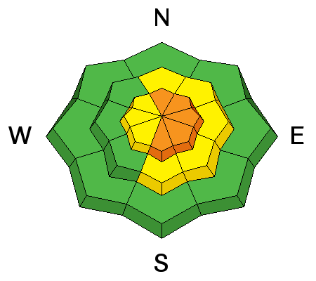
bottom line We start out CONSIDERABLE for new snow avalanches on all aspects at the mid and upper elevations. Human triggered soft slab avalanches and sluffs are probable on slopes 35° and steeper. Stability should increase over the course of the day as the snow becomes less reactive; however this premise rests upon a lack of wind. SAFE travel protocol is required for today: make a plan, communicate, get out of the way at the bottom. Be aware of parties above or below. IF the winds pick up midday into the afternoon ahead of the next wave of snow, the danger will remain at CONSIDERABLE.
|
 |
special announcement Little Cottonwood Canyon Backcountry Closures in Effect Today
|
 |
current conditions It's a good old fashioned cold front, but man did we earn it (see Andy VanHouten's video above). Pre-frontal winds were fierce enough to knock down a few trees, knock skinners over on the skin-track, knock cornices down, trigger a few wind slabs, exfoliate the exposed ridgelines...you get the idea. Hourly averages reached 50-70mph. A few gusts hit 80 to 90. And then, in dramatic fashion, the violent passage of the cold front around dinnertime. Lightning, graupel, the wind shift to the west. Overnight storm totals are an even foot of snow in the central Wasatch Range (Snow/Snow-Water-Equivalent: LCC: 13"/1.31" BCC: 14"/1.20" PC: 12"/1.10"). I suspect we have a couple inches of graupel at the base of the storm snow with decreasing snow densities overnight (aka - what we call a 'right-side-up' storm). Winds are now from the west blowing 10-15mph with occasional gusts to 25. 11,000' wind the last three hours are averaging 20-30mph with gusts to 40. Temperatures are in the upper teens along the ridgelines and in the low 20s at the trailheads. |
 |
recent activity Backcountry activity yesterday involved one natural cornice fall along the Pioneer Ridge along the Brighton periphery that then triggered a 12" deep and couple hundred foot wide wind slab below. Avalanche control work pulled out a couple shallow hard slabs 1-2' deep with explosives in the upper Cottonwoods. In the Logan area mountains, strong winds triggered new wind slabs near Providence Peak. See observation or video below |
| type | aspect/elevation | characteristics |
|---|

|
|
LIKELIHOOD
 LIKELY
UNLIKELY
SIZE
 LARGE
SMALL
TREND
 INCREASING DANGER
SAME
DECREASING DANGER
|
|
description
The questions:
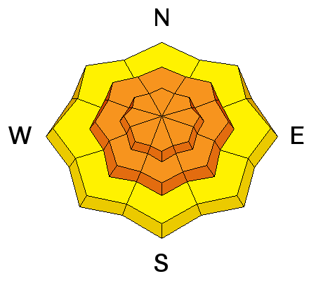
Bottom Line: I expect storm snow avalanches to be most sensitive this morning on all aspects at the mid and upper elevations. Test slopes, cornice drops, and ski cuts by experienced practitioners should provide good information. Sluffing in the low density surface snow on the steepest slopes should be expected in areas lacking a slab. |
| type | aspect/elevation | characteristics |
|---|

|
|
LIKELIHOOD
LIKELY
UNLIKELY
SIZE
LARGE
SMALL
TREND
 INCREASING DANGER
SAME
DECREASING DANGER
|
|
description
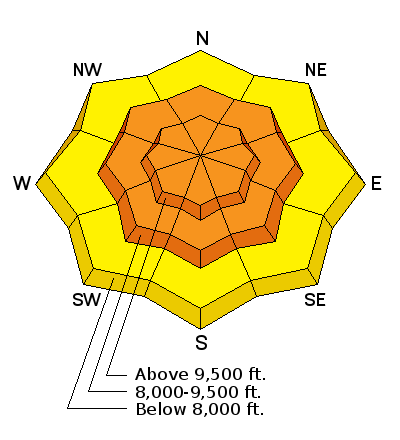
Just enough westerly wind will have created very soft sensitive wind drifts along and probably exclusive to - the high lee ridgelines. These, too, should be sensitive to provocation and reactive to human weight. They will be more likely found on steep north to east to south facing slopes above 9500' along the more exposed ridgelines. Again, ski cuts, cornice drops, test slopes should all provide good indication of site specific conditions. |
| type | aspect/elevation | characteristics |
|---|

|
|
LIKELIHOOD
LIKELY
UNLIKELY
SIZE
 LARGE
SMALL
TREND
 INCREASING DANGER
SAME
DECREASING DANGER
|
|
description
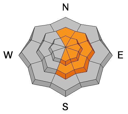
The ever growing cornices will continue to be a significant concern for those traveling along or underneath ridgelines today. It would be a mistake to encroach onto the larger, more concealed cornices to drop a new soft cornice. |
 |
weather We should see light snowfall during the day while the next wave approaches from the west. Mountain temperatures will be in the upper teens along the ridgelines, dropping to near 10°F tonight. Westerly winds should blow 15-20mph today but may increase from the west-southwest in the noon to afternoon hours ahead of the next piece of the storm. The next piece of the storm should kick in by the early evening into overnight. Good dynamics accompanying this storm. I can see another 12" through tomorrow for areas favored by a west to northwest flow. Continued light snowfall is expected through Friday. Saturday looks to be a bit of a break. The GFS model advertises the next storm to affect northern Utah by later Sunday. |
| general announcements Remember your information can save lives. If you see anything we should know about, please help us out by submitting snow and avalanche conditions. You can also call us at 801-524-5304, email by clicking HERE, or include #utavy in your tweet or Instagram. To get help in an emergency (to request a rescue) in the Wasatch, call 911. Be prepared to give your GPS coordinates or the run name. Dispatchers have a copy of the Wasatch Backcountry Ski map. Backcountry Emergencies. It outlines your step-by-step method in the event of a winter backcountry incident. If you trigger an avalanche in the backcountry, but no one is hurt and you do not need assistance, please notify the nearest ski area dispatch to avoid a needless response by rescue teams. Thanks.
EMAIL ADVISORY If you would like to get the daily advisory by email you will need to subscribe here. DAWN PATROL Hotline updated daily by 5-530am - 888-999-4019 option 8. TWITTER Updates for your mobile phone - DETAILS UDOT canyon closures: LINK TO UDOT, or on Twitter, follow @UDOTavy, @CanyonAlerts or @AltaCentral Utah Avalanche Center mobile app - Get your advisory on your iPhone along with great navigation and rescue tools. Powderbird Helicopter Skiing - Blog/itinerary for the day Lost or Found something in the backcountry? - http://nolofo.com/ To those skinning uphill at resorts: it is critical to know the resort policy on uphill travel. You can see the uphill travel policy for each resort here. Benefit the Utah Avalanche Center when you shop from Backcountry.com or REI: Click this link for Backcountry.com or this link to REI, shop, and they will donate a percent of your purchase price to the UAC. Both offer free shipping (with some conditions) so this costs you nothing! Benefit the Utah Avalanche Center when you buy or sell on ebay - set the Utah Avalanche Center as a favorite non-profit in your ebay account here and click on ebay gives when you buy or sell. You can choose to have your seller fees donated to the UAC, which doesn't cost you a penny. This information does not apply to developed ski areas or highways where avalanche control is normally done. This advisory is from the U.S.D.A. Forest Service, which is solely responsible for its content. This advisory describes general avalanche conditions and local variations always |


