25th Annual Black Diamond Fall Fundraising Party
Thursday, September 13; 6:00-10:00 PM; Black Diamond Parking Lot
25th Annual Black Diamond Fall Fundraising Party
Thursday, September 13; 6:00-10:00 PM; Black Diamond Parking Lot
| Advisory: Salt Lake Area Mountains | Issued by Drew Hardesty for Thursday - February 16, 2017 - 5:58am |
|---|

|
bottom line We have a mostly LOW avalanche danger. Wet and dry sluffs in the surface snow are possible in steep terrain. Fresh deposits of wind slab may be shallow and isolated, but sensitive to human provocation. Remember that your choice of terrain will either amplify or minimize the overall risk of incident.
|
 |
special announcement Thursday, Feb 16 - The Utah Adventure Journal Speaker Series presents Brendan Leonard with a presentation at Snowbird's Wildflower Lounge at 6 p.m. about his new book Sixty Meters to Anywhere. The presentation is free, but a donation for the Utah Avalanche Center enters you into a drawing for great prizes. Companion piece to #NothingBadHappened called Hindsight 20/40. |
 |
current conditions Skies are clear. Winds and temperatures have bumped overnight. Southwest winds now spin at 10-15mph with gusts to 20. Overnight lows are at or just above freezing along the ridgelines with mid-elevation temperatures still in the low 40s. Trailheads and valley bottom temps, of course, are in the upper teens to low 20s. Soft settled powder still exists in the mid-elevation shady slopes with supportable corn-like conditions on the south end of the compass. |
 |
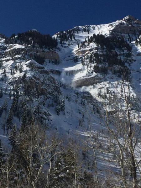
recent activity Reported activity yesterday includes continued wet and dry point release sluffing in steep terrain. Most of these were not big enough to bury a person, though they certainly were enough to knock someone off their feet. Or worse - standing in the runout of long, sustained avalanche paths (see Schutz pic of NE chute of Elk Point on Timpanogos below). The photo below is in Primrose Cirque above Aspen Grove in the north fork of Provo Canyon, just up the street from Sundance resort. Primrose Cirque can be a terrifying place. Not only is the casual recreationist soon surrounded by 270° of avalanche paths, but one path adjacent to the NE Chute of Elk Point - the Theater in the Pines path (down and looker's left of the sluffing snow) - occasionally runs down to the parking area where it twice took out an Avalanche Danger sign in the 1990s. The Primrose Cirque has also claimed the lives of four people over the past 15 years.
|
| type | aspect/elevation | characteristics |
|---|

|
|
LIKELIHOOD
 LIKELY
UNLIKELY
SIZE
 LARGE
SMALL
TREND
 INCREASING DANGER
SAME
DECREASING DANGER
|
|
description
Normal Caution. Remember that risk is inherent in mountain travel. Avalanche concerns for the backcountry include the following:
|
 |
weather A weakening storm will bring us some clouds, increased southwesterly winds, and perhaps a trace to 2" overnight. The weekend storm is diving well to the south of us but should keep us under an unsettled southerly flow with a few inches of snow likely over the weekend. For today, expect southwesterly winds to blow 20-30mph. Higher hourly averages expected north of I-80. Mountain temps will reach to near 50° at 8500'. |
general announcements
|