25th Annual Black Diamond Fall Fundraising Party
Thursday, September 13; 6:00-10:00 PM; Black Diamond Parking Lot
25th Annual Black Diamond Fall Fundraising Party
Thursday, September 13; 6:00-10:00 PM; Black Diamond Parking Lot
| Advisory: Salt Lake Area Mountains | Issued by Evelyn Lees for Sunday - February 12, 2017 - 6:18am |
|---|

|
bottom line The avalanche danger is MODERATE this morning, but will rise to CONSIDERABLE by afternoon on steep, sunny slopes for wet loose sluffs. Most other slopes, including mid and low elevation shady slopes, will have a MODERATE danger for wet sluffs as the day heats up. Be very alert for rapidly warming snow over short periods of time today and as you change elevations and aspects. When the snow becomes damps where you are, move to lower angle terrain or a cooler aspect. On steep upper elevation slopes, there remains a MODERATE danger of triggering a new snow slide or fresh wind drift. Cornices can break back further than expected.
|
 |
special announcement Wasatch Backcountry Skiing Weather: Friends of the UAC President Steve Achelis has done it again: check out his one-stop-shop page here. |
 |
current conditions It’s a crisp, cool morning with clear skies and temperatures in the upper teens to low 20s. Winds are from an easterly direction, and most stations are averaging less than 15 mph, though a few of the highest peaks are averaging 20 to 25 mph, with gusts to 35. |
 |
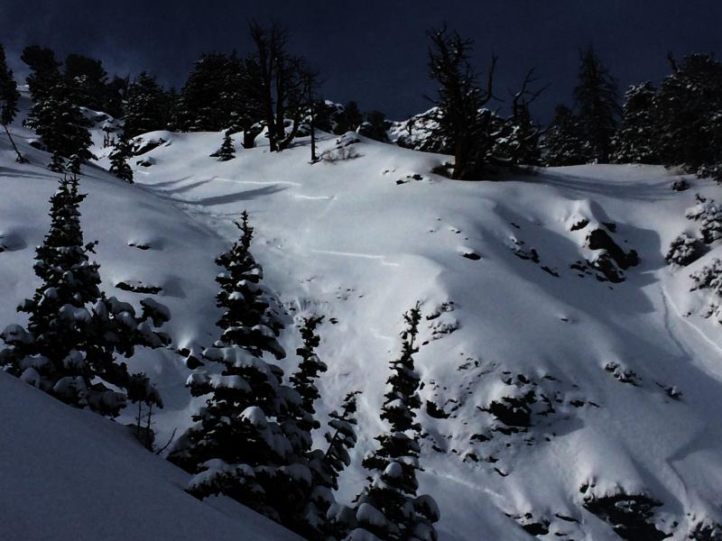
recent activity Yesterday, there were 5 new snow soft slabs triggered in the backcountry, all above about 9900’ on east to northeasterly facing slopes. They were long running, and two of them propagated widely, up to 250’. There was similar activity from resort and highway control work in the Cottonwoods, which received the most snow. Explosives, artillery and ski cuts released larger new snow slides (D1 to D2), and an isolated natural avalanche cycle occurred at the peak of the storm in Little Cottonwood. A different sort of slide, failing on wet grains, was triggered early afternoon on a southeast facing slope at 9200’. Left: East couloir, Kessler C Brown photo. Note how the slide continued to break out as it moved down slope, entraining snow. Right: Scott Hill, AT photo
|
| type | aspect/elevation | characteristics |
|---|

|
|
LIKELIHOOD
 LIKELY
UNLIKELY
SIZE
 LARGE
SMALL
TREND
 INCREASING DANGER
SAME
DECREASING DANGER
|
|
description
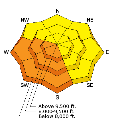
Even with a decent overnight refreeze and a cold start to the morning, the direct sun will be strong today, heating the new snow. Expect to easily trigger wet sluffs on steep sunny slopes as the snow becomes damp - first on east then south then west. Roller balls and pinwheels are a first sign of heating. I expect wet loose sluffs to be triggered on the mid and low elevation shady, northerly facing slopes, too, because the buried old snow is still damp. Dense wet snow can quickly catch you and push you around, and even small steep terrain features such as road and creek banks can pile up enough debris to bury a person. Glide avalanches can occur any time, and have been most active in Broads Fork this month. |
| type | aspect/elevation | characteristics |
|---|

|
|
LIKELIHOOD
 LIKELY
UNLIKELY
SIZE
LARGE
SMALL
TREND
 INCREASING DANGER
SAME
DECREASING DANGER
|
|
description
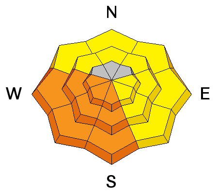
Keep a sharp eye on the wind speeds where you are today. Currently, all but 3 stations are averaging less than 15 mph. But even a small uptick in the wind speed can start to drift snow. Look for and avoid the rounded wind drifts, which will be found along the upper elevation ridgelines on a variety of aspects, including westerly. If you are heading to the highest peaks of the range today, you will find wind slabs. The new storm snow could still be sensitive today on steep upper elevation slopes. These slides have been long running and mostly on north through easterly facing slopes. Cornices are still an issue. Both old and new cornices are sensitive, break back further than you would expect, and a cornice could trigger a new snow slide on the slope below. |
| type | aspect/elevation | characteristics |
|---|

|
|
LIKELIHOOD
 LIKELY
UNLIKELY
SIZE
LARGE
SMALL
TREND
INCREASING DANGER
SAME
DECREASING DANGER
|
|
description
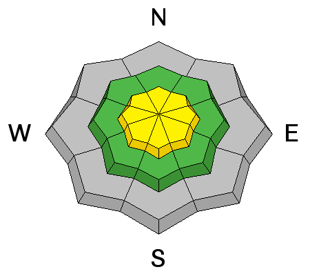
Guilty until proven innocent….hopefully we can take this one to court soon and be done with it. I’m thinking the surface hoar layer became wet at the low elevations, and the most likely place to trigger a slide on it would be above around 8,000’. Again, it was mostly isolated to the low and mid elevation shady slopes at the northern end of the Park City ridge line to Parleys Canyon. |
 |
weather A beautiful day with clear, sunny skies – if only it wasn’t going to be so warm. Temperatures will rise to near 40 at 8000’ and into the upper 20s at 10,000’. The easterly winds should remain light, averaging less than 15 mph. High pressure will remain over the area through Thursday, with unseasonably warm temperatures once again by midweek. An active weather pattern with a series of storms should resume around Friday. |
general announcements
|