25th Annual Black Diamond Fall Fundraising Party
Thursday, September 13; 6:00-10:00 PM; Black Diamond Parking Lot
25th Annual Black Diamond Fall Fundraising Party
Thursday, September 13; 6:00-10:00 PM; Black Diamond Parking Lot
| Advisory: Salt Lake Area Mountains | Issued by Drew Hardesty for Thursday - February 9, 2017 - 5:57am |
|---|

|
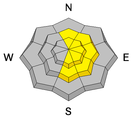
bottom line The danger will rise to CONSIDERABLE for wet loose and possibly wet slab avalanches on all aspects at the low to mid elevations. Even damp rollerballs and wet sluffs may be expected with provocation on all but the highest northerly elevations due to light rain and rapid warming. These will be unusual conditions over the next 48+ hours. Great uncertainty with these conditions warrants great caution. Cornice-fall, Roof and Glide avalanches are all inherently dangerous...and all are quite possible today. Ice climbing is not recommended.
|
 |
special announcement Tonight: Thursday 2/9- This week the Utah Adventure Journal Speaker Series hosts professional ski-mountaineer Andrew McLean. Andrew has a PhD in mountain mistakes and will be sharing lessons learned from personal ski mountaineering experiences with avalanches, crevasses, long falls, getting lost, partner malfunctions and many other mountain mishaps. Andrew is the author of The Chuting Gallery and a veteran of over 25 skiing expeditions. For all event details click here. Wasatch Backcountry Skiing Weather: Friends of the UAC President Steve Achelis has done it again: check out his one-stop-shop page here. |
 |
current conditions Maritime. The coastal ranges called, they want their weather back. Under overcast skies, overnight lows are in the mid 30s at 9500'. Base areas and trailhead overnight lows are in the upper 30s to mid-40s. Light precipitation continues to fall with a rain/snow line to almost 9500'. At least the southwesterly winds are blowing 20-25mph with gusts to 45. Snow surface conditions are a mixed bag of quasi-corn-like conditions on the southerly aspects to supportable mist-crust overlying cream-cheese in the higher northerly terrain. Slide for life conditions on a 1-3" thick rain crust are reported in the low to mid elevations of Provo. Video clip by Woody - https://youtu.be/o2d_Og5FgZ0 |
 |
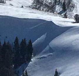
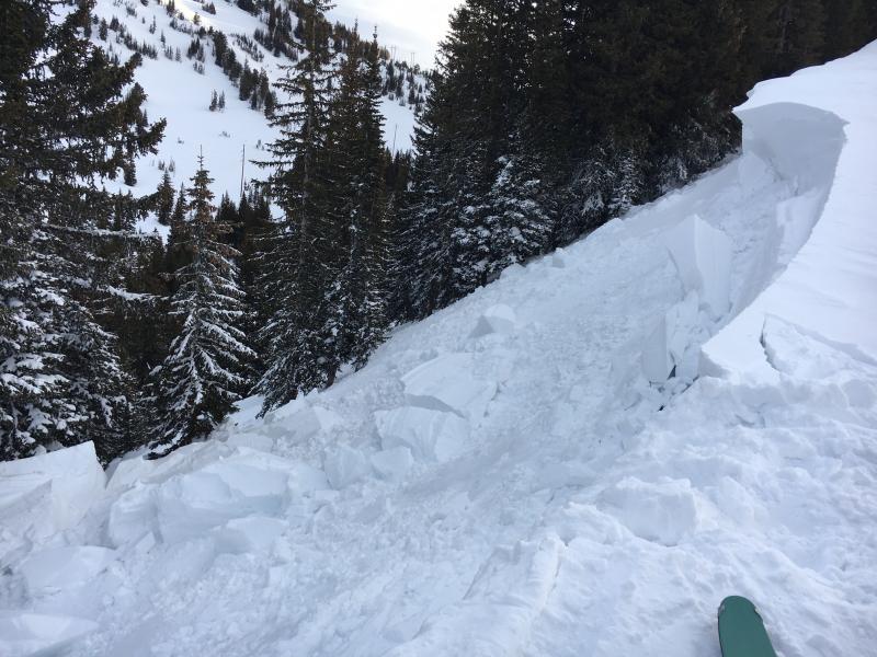
recent activity Mountain resort control teams triggered shallow wind drifts in the high elevation terrain yesterday, but in the backcountry, natural and human triggered cornice fall did most of the damage. A number of cornices pulled way, way back onto the ridgelines in the upper reaches of the Cottonwoods and along the PC ridgeline, with some in turn triggering otherwise healing wind slabs 1-2' deep and up to 100' wide. One skier inadvertently went down with a collapsed cornice along the Patsy Marley ridgeline but was no worse for wear. These cornices and subsequent wind slabs generally faced north to east above 9500'...although suspect cornices may be found along ridgelines at much lower elevations. (pic: Mark White). Natural wet sluffing also noted in saturated, thinner snowpack areas from Summit Park to City Creek.
|
| type | aspect/elevation | characteristics |
|---|

|
|
LIKELIHOOD
 LIKELY
UNLIKELY
SIZE
 LARGE
SMALL
TREND
 INCREASING DANGER
SAME
DECREASING DANGER
|
|
description
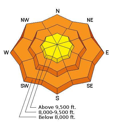
Cloud cover, a poor overnight refreeze, and light rain will keep wet loose and wet slab avalanches on the forefront. Furthermore, today's mountain temperatures will rise to the low 40s F at 10,000' by the afternoon; therefore even snow on all but the highest northerly elevations will start to rollerball and perhaps produce some wet sluffs with provocation in steep terrain. Unsupportable wet snow can be avalanche-prone and is a key sign to move to lower angle terrain. ROOF AVALANCHES continue to be a significant concern. Avoid being in the "runout zones". GLIDE releases should be on your radar in the standard glide avalanche regions of Broads Fork, Stairs Gulch, and localized areas of Mill B south. Full-depth glide releases are notoriously unpredicatable, but rain and melt-water percolating down onto the smooth underlying rock slabs below is a classic contributing factor. |
| type | aspect/elevation | characteristics |
|---|

|
|
LIKELIHOOD
LIKELY
UNLIKELY
SIZE
 LARGE
SMALL
TREND
INCREASING DANGER
SAME
DECREASING DANGER
|
|
description
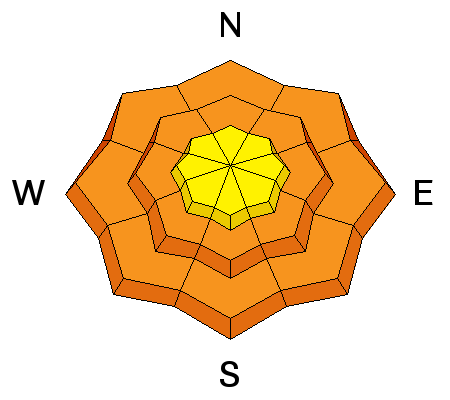
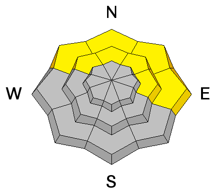
These monster cornices continue to calve upon approach, often with little warning. They deserve a great deal of respect and caution. We've suffered a few tragic fatalities over the years with unsuspecting people trap-dooring through a cornice and killed by trauma on the ride down. Cornice-fall may still be able to crow-bar out a few lingering wind slabs below.
|
| type | aspect/elevation | characteristics |
|---|

|
|
LIKELIHOOD
 LIKELY
UNLIKELY
SIZE
LARGE
SMALL
TREND
 INCREASING DANGER
SAME
DECREASING DANGER
|
|
description
These persistent buried weak layers of surface hoar or small faceted crystals on an ice crust mostly exist on low and mid elevation shady slopes at the northern end of the Park City ridgeline to Parleys Canyon. Snow tests indicate that human triggered avalanches are still possible in this structure, albeit in very localized terrain. |
 |
weather We'll have overcast skies and light rain that may be a bit more pronounced in Ogden and areas north. Winds will blow 30-40mph from the west southwest. Mountain temperatures will reach into the low 40s at 10,000'. 8000' temps will reach the low 50s. The next "atmospheric river" event kicks in overnight into Friday with a cold front following for overnight Friday into Saturday. The rain-snow line may initially hit 9500', though 9000' seems more likely. Expected snow totals are 10-18" through later Saturday. |
general announcements
|