25th Annual Black Diamond Fall Fundraising Party
Thursday, September 13; 6:00-10:00 PM; Black Diamond Parking Lot
25th Annual Black Diamond Fall Fundraising Party
Thursday, September 13; 6:00-10:00 PM; Black Diamond Parking Lot
| Advisory: Salt Lake Area Mountains | Issued by Mark Staples for Monday - February 6, 2017 - 6:27am |
|---|

|
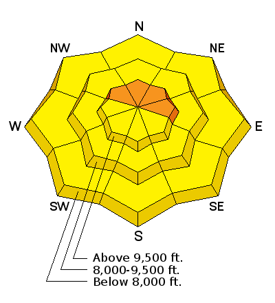
bottom line The avalanche danger today is CONSIDERABLE at upper elevations where fresh wind slabs can easily be triggered. The danger is MODERATE at mid to lower elevations. Dig into the snow to look for weak layers that can cause persistent slab avalanches, and watch for loose, wet snow avalanches at the lowest elevations.
|
 |
special announcement Tomorrow, February 7 at the Sandy REI: Know Before You Go - a free avalanche awareness program. Not much science, no warnings to stay out of the mountains, no formulas to memorize. In 1 hour, you will see the destructive power of avalanches, understand when and why they happen, and how you can have fun in the mountains and avoid avalanches. If you have time to kill, check out our recorded live Instagram digital fireside chat from Wednesday night. These fireside chats are informal discussions on the state of the snowpack and involve questions and comments from viewers. We hope to have more in the coming weeks. |
 |
current conditions Strong southerly winds arrived late last night, and a trace to one inch of snow fell. This morning they are averaging 20-40 mph gusting to 50 mph from the S and SW. Temperatures are near freezing at 8000 feet with temperatures in the mid 20's F at higher elevations. Soft powder can still be found on shaded and sheltered terrain. Winds blasted the snow surface at higher elevations and the sun melted the snow surface on southerly aspects yesterday which is now refrozen. At low elevations the snow likely remains wet. |
 |
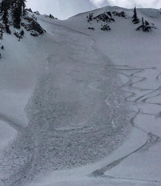
recent activity Some wind slabs were triggered on Saturday. With increased winds overnight, there should be more wind slabs you can trigger today. Photo: M.White
|
| type | aspect/elevation | characteristics |
|---|

|

|
LIKELIHOOD
 LIKELY
UNLIKELY
SIZE
 LARGE
SMALL
TREND
 INCREASING DANGER
SAME
DECREASING DANGER
|
|
description
Strong southerly winds have formed fresh wind slabs this morning which should be easy to trigger. With a little snow expected today and continued strong winds, fresh wind slabs should remain sensitive and become larger throughout the day. Many ridgelines have massive cornices which will continue growing this week with more snow and more wind. These are unpredictable and have killed many experienced mountaineers. They often break further back than many expect. Avoid traveling near these monsters. |
| type | aspect/elevation | characteristics |
|---|

|
|
LIKELIHOOD
 LIKELY
UNLIKELY
SIZE
LARGE
SMALL
TREND
INCREASING DANGER
SAME
DECREASING DANGER
|
|
description
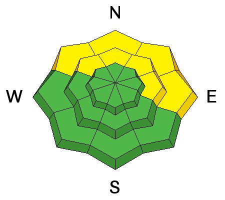
The persistent slab avalanche problem mostly exists on the northern end of the Park City ridgeline to Parleys Canyon. It is caused by either a buried layer of surface hoar or small faceted crystals on an ice crust. Fortunately, there's an easy way to know if this problem exists: dig 3 feet into the snow, look for a stripe in a clean pit wall, and do a quick extended column test. With some practice, this process should only take 5 minutes. Just before dropping into a steep E facing bowl in the Uintas yesterday, my partners and I stopped to look for these layers. They produced unstable results in our tests (video), and we chose not to ride in that bowl. Later yesterday, I went to the head of Big Cottonwood Canyon near Guardsman Pass where I found a similar layer about 3 feet deep. Strong winds destroyed this layer before it was buried. I could not get it to break and would have felt comfortable riding in avalanche terrain but had to get home to watch the greatest comeback in Super Bowl history! |
| type | aspect/elevation | characteristics |
|---|

|
|
LIKELIHOOD
LIKELY
UNLIKELY
SIZE
 LARGE
SMALL
TREND
 INCREASING DANGER
SAME
DECREASING DANGER
|
|
description
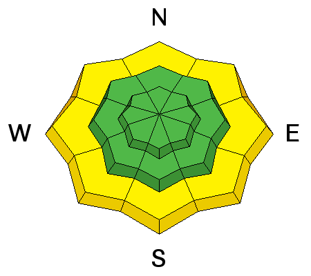
Some loose wet avalanches are possible at the lowest elevations where overnight temperatures were near 40 degrees F. Watch for these slides if any rain falls. Watch Toby's video about loose wet slides in Logan Canyon. |
 |
weather Today freezing temperatures should remain near 8000 feet though the rain snow line should be closer to 6000 feet. Strong winds will continue from the SW blowing 20-30 mph. At the highest elevations, much stronger winds will blow with gusts over 70 mph. Snowfall today should only bring a few inches. Heavier snowfall will occur tonight with and additional 7-10 inches possible. The rain/snow line should rise to 7500 feet this evening and Tuesday and then drop tomorrow afternoon. |
general announcements
|