25th Annual Black Diamond Fall Fundraising Party
Thursday, September 13; 6:00-10:00 PM; Black Diamond Parking Lot
25th Annual Black Diamond Fall Fundraising Party
Thursday, September 13; 6:00-10:00 PM; Black Diamond Parking Lot
| Advisory: Salt Lake Area Mountains | Issued by Greg Gagne for Friday - February 3, 2017 - 5:14am |
|---|

|
bottom line The avalanche danger is MODERATE for wind drifted snow and fresh cornices at the upper elevations. Although these are likely to be found at and just below upper elevation ridges facing northwest through southeast, increasing winds this afternoon may drift snow on all upper elevation aspects, as well as in open terrain at the mid elevations. The avalanche danger is also MODERATE on mid and low elevations slopes facing northwest through east where slab avalanches up to 2 feet deep can be triggered failing on a buried layer of surface hoar. Faceted weak layers also exist on other aspects and elevations, but are more isolated.
|
 |
special announcement On Tuesday February 7 at the Sandy REI is the next presentation of Know Before You Go - a free avalanche awareness program. Not much science, no warnings to stay out of the mountains, no formulas to memorize. In 1 hour, you will see the destructive power of avalanches, understand when and why they happen, and how you can have fun in the mountains and avoid avalanches. Also - for those that enjoy podcasts - Doug Krause has an excellent new avalanche-related podcast appropriately named Slide. It is a nice combination of practical advice, snow science, as well as human factor issues. |
 |
current conditions As of 5 am, temperatures are in the low twenties in the central Wasatch. Winds are out of the west and south west, gusting in the teens and twenties at the mid and upper elevations. 2-4” of fresh snowfall was reported from Big and Little Cottonwood Canyons, as well as the Park City mountains, on Thursday. This small refresher improved skiing and riding conditions. This was the first snowfall since Thursday January 26; it has felt like an eternity. Week in Review Friday January 27 was a stunning bright and bluebird day, with several feet of fresh snow that had fallen the prior eight days. However, six human triggered avalanches were reported that day, primarily in the Park City mountains as well as Lambs Canyon and Summit Park in Parleys Canyon. These occurred in elevations ranging from 7600’ - 9400’ and on northwest through southeast aspects. The weak layers were either preserved surface hoar or near surface facets, buried down 2-3’ in the snowpack. Trent produced an excellent video recap of the avalanche that occurred on Sound of Music in the Park City mountains on the 27th. This video describes the persistent weak layer, as well as efficacy of avalanche safety equipment. On Sunday Jan 29 and well as Tuesday Jan 31, two additional human-triggered slides were reported, one on Murdock Peak on a northeast aspect at 7600, the other in Summit Park on a north aspect at 8200’. Both failed on a layer of preserved surface hoar buried down about 2'. Otherwise, while the Salt Lake valley was mired in an atmospheric inversion, the mountains were warm and mostly sunny. This extended period of clear weather weakened the snow surface, leaving behind a layer of surface hoar and near surface facets on most sun-sheltered aspects, and a breakable sun and temperature crust on other aspects. Fortunately, moderate to occasionally strong winds early this week, as well as warm temperatures, have seemingly destroyed these weaknesses at the old snow surface. With a few inches of snow from Thursday, and more snow on the horizon, it will be important to evaluate the old snow surface for any preserved weak layers underneath any new snow. January Alta Guard Summary 8700' (Thanks to Mark Sauer) You didn't just imagine it, January was a snowy month with 154" of snow with 13.3" of water. This is the 6th highest January snow/water on record. (Average is 91.5" with 8.6" of water.) |
 |
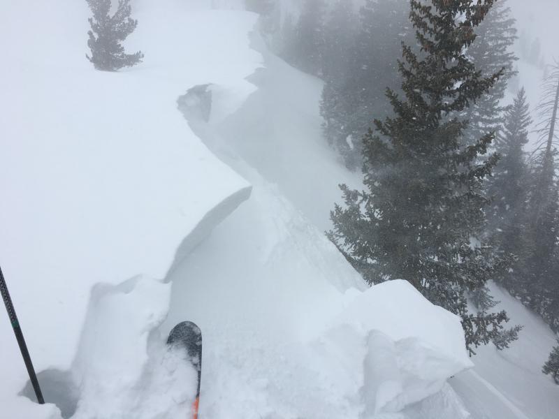
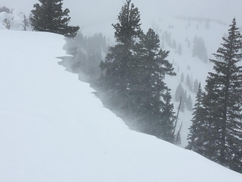
recent activity On Thursday observers were finding pockets of sensitive wind drifts and small cornices along upper elevation ridge lines from southwest winds. These were mostly shallow - up to 6”. Little wind affect was noted down off of the ridges. Others were finding sluffing in the new snow, but it required steeper angles (> 35 degrees). Otherwise no avalanche activity to report.
|
| type | aspect/elevation | characteristics |
|---|

|
|
LIKELIHOOD
 LIKELY
UNLIKELY
SIZE
 LARGE
SMALL
TREND
 INCREASING DANGER
SAME
DECREASING DANGER
|
|
description
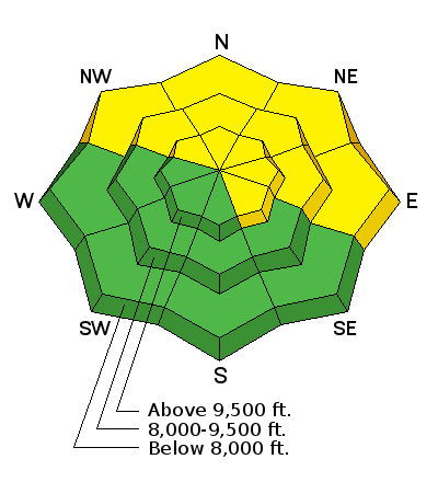
Pockets of wind drifts as well as fresh cornices from west/southwest winds may be sensitive today. They are currently easy to identify and are easily managed with effective ski cuts. Although these will be found primarily along upper elevation ridges on leeward aspects, as wind speeds increase this afternoon, drifting is possible on all upper elevation aspects, as well as in open bowls and exposed terrain at the mid elevations.
|
| type | aspect/elevation | characteristics |
|---|

|
|
LIKELIHOOD
LIKELY
UNLIKELY
SIZE
LARGE
SMALL
TREND
 INCREASING DANGER
SAME
DECREASING DANGER
|
|
description
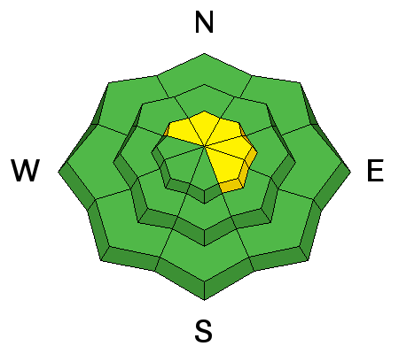
They are called persistent slabs for a reason. Although the last human-triggered slide on our persistent weak layer was reported on Tuesday, I'm not ready to put this problem to rest. Yesterday I was still producing clean shears at this weak layer which is buried down about 2'. There are two different layers to search for: (1) a layer of surface hoar, and (2) a layer of near-surface facets sitting just above a crust. These weaknesses have been most reactive on the northern end of the Park City ridgeline, extending to Parleys Canyon. They are found primarily on northwest through east aspects, on sheltered low and mid elevation terrain. Although triggering avalanches on this weak layer is becoming less likely, any avalanche you do trigger would be a dangerous 2' slab avalanche. To identify the surface hoar weakness, dig down to at least 2' with your shovel, and look for a white stripe of surface hoar. The video below from Jake Hutchinson and his Level 3 avalanche class demonstrates how to find and evaluate this weak layer: 02.01.2017.surfacehoar from Jake Hutchinson on Vimeo. |
 |
weather Temperatures will be in the low 20's F at 10000', and low 30's F at 8000'. Generally light to moderate winds from the west and southwest this morning. The activity begins to pick up this afternoon as wind speeds increase, with gusts into the 30’s at mid elevations, and 50’s at upper elevations. Snowfall should also begin this afternoon, arriving on a west/southwest flow, with a few inches possible by later this afternoon. Snowfall and winds continue overnight and into Saturday morning, with 5-10" of snow possible by later in the day Saturday. After a brief break, Monday through at least Wednesday looks warm and wet as a westerly storm track returns to the region. |
general announcements
|