25th Annual Black Diamond Fall Fundraising Party
Thursday, September 13; 6:00-10:00 PM; Black Diamond Parking Lot
25th Annual Black Diamond Fall Fundraising Party
Thursday, September 13; 6:00-10:00 PM; Black Diamond Parking Lot
| Advisory: Salt Lake Area Mountains | Issued by Evelyn Lees for Thursday - February 2, 2017 - 6:51am |
|---|


|
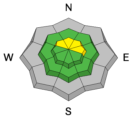
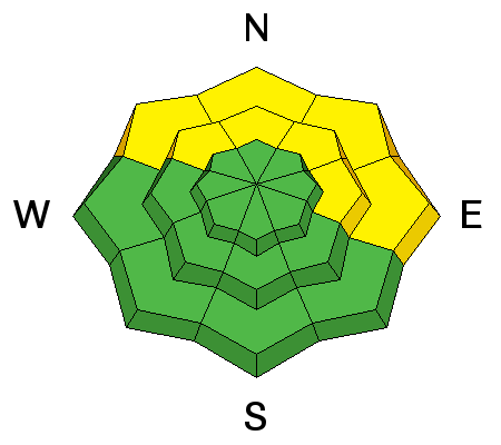
bottom line The avalanche danger is MODERATE on steep wind drifted, upper elevation slopes, with the drifts most widespread on northwest through easterly facing slopes. The avalanche danger is also MODERATE on mid and low elevations slopes facing northwest through east where slab avalanches up to 2 feet deep can be triggered failing on a buried layer of surface hoar. Faceted weak layers also exist on other aspects and elevations, but are more isolated.
|
 |
special announcement Tonight! - Thursday February 2nd - Utah Adventure Journal hosts professional adventure skier Mike Marolt, a high altitude skier with 30 years of expeditions to some 50 of the world’s 6,000 to 8,000 meter peaks. For this event, he will be screening Skiing Everest, a feature length documentary film profiling he and his identical twin brother in their pursuit of high altitude skiing in the late 90’s. For details click here. |
 |
current conditions The groundhog on Gobbler’s Knob...Pennsylvania, has predicted six more weeks of winter…and here’s hoping Utah is included in his forecast zone! Overnight, temperatures and winds have dropped. Temperatures are in the mid to low 20s this morning, and the southwesterly winds are averaging 10-15 mph under partly cloudy skies. It’s a bit windier in both the Provo and Ogden area mountains, where the ridge lines have been gusting in the 40s. |
 |
recent activity A few small wet loose sluffs occurred at the lower elevations yesterday and a large collapse was reported from an ESE facing slope, along the northern Park City ridge line. |
| type | aspect/elevation | characteristics |
|---|

|
|
LIKELIHOOD
 LIKELY
UNLIKELY
SIZE
 LARGE
SMALL
TREND
 INCREASING DANGER
SAME
DECREASING DANGER
|
|
description
It is still possible to find isolated wind slabs at the upper elevations that could crack out under the weight of a person. The most likely spot would be in upper elevation terrain facing northwest through easterly. |
| type | aspect/elevation | characteristics |
|---|

|
|
LIKELIHOOD
 LIKELY
UNLIKELY
SIZE
LARGE
SMALL
TREND
 INCREASING DANGER
SAME
DECREASING DANGER
|
|
description
There are two buried persistent weak layers - surface hoar and facets above a crust - that are less predictable. The surface hoar is most widespread in wind sheltered, shady low and mid elevation terrain, with the northern end of the Park City ridge line north to I-80 where the most slides have been triggered on this layer. This same region also had a large slide on small facets above a crust layering on a southeast-facing slop. These weak faceted layers have been found other areas, but are much more isolated in distribution. Today, while there is a low chance of triggering a slide breaking on either of these weak layers, if you do, it would be a dangerous slab avalanche, about 2 feet deep. These faceted layers can be triggered remotely from a distance, from low angle slopes or be stubborn break above you or on the third person on a slope. The best way to find the surface hoar layer is to get a shovel out and look for the “stripe” about 2 feet down. Note in the video below you can identify the weak layer even before it pops out on the stability test. 02.01.2017.surfacehoar from Jake Hutchinson on Vimeo. |
 |
weather A weak weather disturbance will cross the area today through this evening. Skies will be mostly cloudy today and tonight, with snow flurries producing a trace to an inch or two of snow. 8000’ highs will warm into the mid 30s, 10,000’ highs will be in the low to mid 20s. The southwesterly winds will be light, generally less than 10 mph. Only the highest peaks will average 25 to 35 mph, with gusts in the 40s. A somewhat stronger, warm storm will affect the area late Friday through Saturday, producing another few inches of snow, with the rain/snow line around 6000’ at times. After a break on Sunday, a better snow producer is forecast for Monday into Tuesday. |
| general announcements Remember your information can save lives. If you see anything we should know about, please help us out by submitting snow and avalanche conditions. You can also call us at 801-524-5304, email by clicking HERE, or include #utavy in your tweet or Instagram. To get help in an emergency (to request a rescue) in the Wasatch, call 911. Be prepared to give your GPS coordinates or the run name. Dispatchers have a copy of the Wasatch Backcountry Ski map. Backcountry Emergencies. It outlines your step-by-step method in the event of a winter backcountry incident. If you trigger an avalanche in the backcountry, but no one is hurt and you do not need assistance, please notify the nearest ski area dispatch to avoid a needless response by rescue teams. Thanks.
EMAIL ADVISORY If you would like to get the daily advisory by email you will need to subscribe here. DAWN PATROL Hotline updated daily by 5-530am - 888-999-4019 option 8. TWITTER Updates for your mobile phone - DETAILS UDOT canyon closures: LINK TO UDOT, or on Twitter, follow @UDOTavy, @CanyonAlerts or @AltaCentral Utah Avalanche Center mobile app - Get your advisory on your iPhone along with great navigation and rescue tools. Powderbird Helicopter Skiing - Blog/itinerary for the day Lost or Found something in the backcountry? - http://nolofo.com/ To those skinning uphill at resorts: it is critical to know the resort policy on uphill travel. You can see the uphill travel policy for each resort here. Benefit the Utah Avalanche Center when you shop from Backcountry.com or REI: Click this link for Backcountry.com or this link to REI, shop, and they will donate a percent of your purchase price to the UAC. Both offer free shipping (with some conditions) so this costs you nothing! Benefit the Utah Avalanche Center when you buy or sell on ebay - set the Utah Avalanche Center as a favorite non-profit in your ebay account here and click on ebay gives when you buy or sell. You can choose to have your seller fees donated to the UAC, which doesn't cost you a penny. This information does not apply to developed ski areas or highways where avalanche control is normally done. This advisory is from the U.S.D.A. Forest Service, which is solely responsible for its content. This advisory describes general avalanche conditions and local variations always exis |


