25th Annual Black Diamond Fall Fundraising Party
Thursday, September 13; 6:00-10:00 PM; Black Diamond Parking Lot
25th Annual Black Diamond Fall Fundraising Party
Thursday, September 13; 6:00-10:00 PM; Black Diamond Parking Lot
| Advisory: Salt Lake Area Mountains | Issued by Drew Hardesty for Saturday - January 28, 2017 - 5:56am |
|---|

|
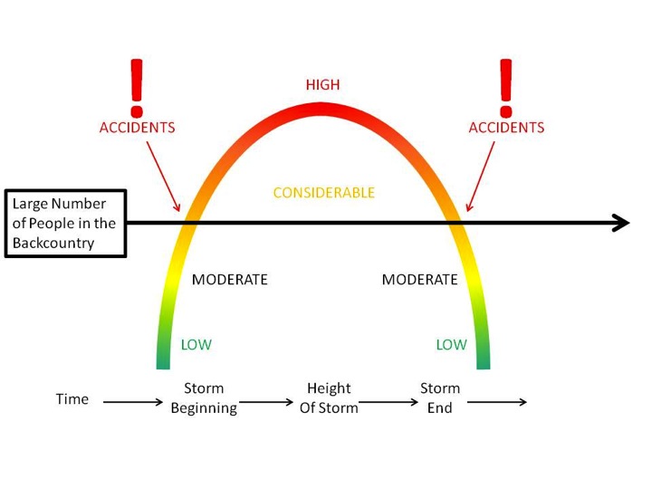
bottom line A CONSIDERABLE avalanche danger exists in the central Wasatch. Human triggered avalanches 2-3' deep are likely today on a variety of aspects and elevations. This weekend has accident written all over it: most of our accidents and fatalities occur under conditions like these. Remember that when you're accessing the backcountry from the mountain resorts, you're stepping into dangerous avalanche conditions.
|
 |
special announcement Do you buy groceries at Smiths? Register your Smith’s rewards card with their Community Rewards program, and they will donate to the Utah Avalanche Center whenever you make a purchase. It's easy, only takes a minute, and doesn't cost you anything. Details |
 |
current conditions Skies are clear. Under the tightening noose of a building ridge of high pressure, mountain temperatures are now at 24 hour highs in the mid teens. Gusty northerly winds continue to move snow and damage the open exposed terrain. They're still blowing 20-25mph with gusts to 30. 11,000' anemometers spin 35 mph with gusts to 50. Out of the wind and sun-zippered terrain, riding conditions remain superb, though a bit slow, on the recrystallizing snow surface and 1-2mm surface hoar from Thursday night. Required Reading: Week in Review by Greg Gagne Wow. A prolonged period of storms began late in the day on Friday Jan 20th, with an overachieving storm on Saturday the 21st with numerous human-triggered as well as natural avalanches occurring over the weekend. (Mark Staples described the activity of the weekend of Jan 21/22.) Strong winds and heavy snowfall led to an avalanche warning issued by the UAC on Monday and Tuesday January 23/24 for the mountains of northern Utah. Little Cottonwood Canyon was closed beginning on Monday morning due to dangerous avalanche activity, and did not re-open until later Tuesday morning. Results from highway control work on several mountain roads in northern Utah produced large avalanches, with many hitting the road. A couple of Wasatch veterans reminded me that this is how "it used to be." Throughout this extended period numerous natural and human triggered avalanches were reported on a variety of aspects and elevations, with several avalanches occurring at low elevations (< 9000'). Weaknesses included wind drifts, density changes within storm snow events, and persistent weak layers that formed during the spell of clear and cold weather from Jan 13 - 18, including both near-surface facets and surface hoar. Your pre-trip preparations should include reading field observations as well as recent avalanche activity from this past week. Bottom line - it was snowing and blowing for over a week, with storm snow falling on top of a weak, pre-existing snow surface at the mid and lower elevations, and it has led to a variable and complex snowpack. Approximate storm and water totals since Jan 20 include: LCC/BCC 80" 5.7" |
 |
recent activity Requires a three part answer: persistent slabs, wind slabs, and minor wet loose point releases.
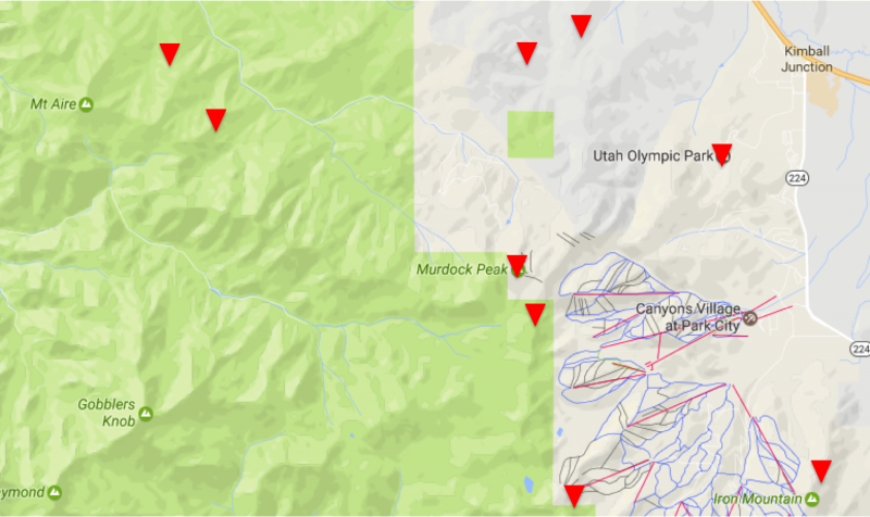
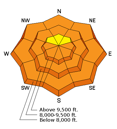
Evelyn created a map depicting locations for these recent human triggered persistent slabs. Note these have been on many aspects below 9500' and predominantly along the northern periphery of the Cottonwoods (Park City ridgeline, Summit Park, Mount Aire). Note that a couple of the wind slabs are included on the activity rose on the right - these account for the upper elevation slides. On another note, I was blown away by the number of people who submitted reports and observations yesterday- your information saves lives. Thank you.
|
| type | aspect/elevation | characteristics |
|---|

|
|
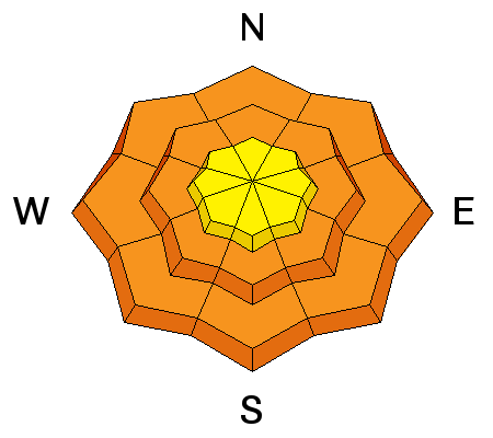
LIKELIHOOD
 LIKELY
UNLIKELY
SIZE
 LARGE
SMALL
TREND
 INCREASING DANGER
SAME
DECREASING DANGER
|
|
description
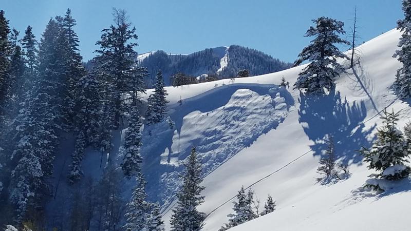
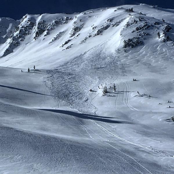
Evidence based information: at least eight human triggered persistent slabs reported since Tuesday. Subtle to thunderous whoomphs and collapses noted as the storm snow collapses the weak surface hoar and facets that were not destroyed prior to last week's storm. Many of these triggered at a distance, fracturing out above the skier, or just adjacent to other tracks on the slope. The weakest and most suspect terrain is at the mid and low elevations on many aspects, but predominantly - but not all - on north to southeast facing slopes. These are dangerous, unmanageable avalanches. See a couple photos below (Barker, Ellis). Click the 'i' next to the Persistent Slab icon for travel advice and more information on these types of avalanches. You have three choices: roll the dice, do the homework, or stay off (and out from underneath) slopes approaching 35° and steeper.
|
| type | aspect/elevation | characteristics |
|---|

|
|
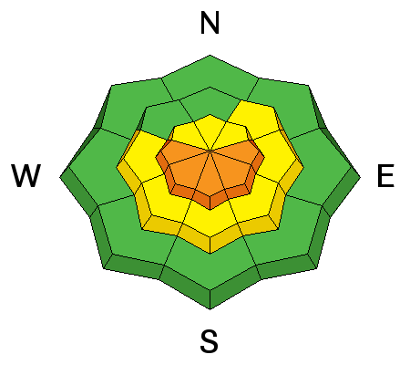
LIKELIHOOD
LIKELY
UNLIKELY
SIZE
 LARGE
SMALL
TREND
INCREASING DANGER
SAME
DECREASING DANGER
|
|
description
Fresh wind drifts. Gusty north-northwest to north-northeast winds fostered the development of 10-18" deep drifts along the higher exposed terrain yesterday and may have been particularly sensitive as they drifted on weak surface snow (1-1.5mm surface hoar and recrystallized snow). Naturals high along the Ivory Flakes along with human triggered slides on Superior and the high periphery south of Snowbird are representative of what you'll find today. See the Steve Achelis map for location details. These rounded drifts will still be sensitive to human provocation and may be triggered at a distance. The drifts will be more pronounced just to the lee of the exposed peaks and ridges. Sean Zimmerman Wall had a good observation in the Snowbird periphery. Photos White (Cardiac Ridge), Tuura (Little Superior).
|
| type | aspect/elevation | characteristics |
|---|

|
|
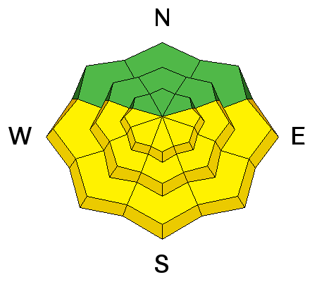
LIKELIHOOD
LIKELY
UNLIKELY
SIZE
LARGE
SMALL
TREND
 INCREASING DANGER
SAME
DECREASING DANGER
|
|
description
Cold, dry snow under the heat lamp and with mountain temps rising into the mid 20s at 10,000' will conspire to dampen the snow surfaces on the steep sunlit slopes. With prolonged dampening, both natural and especially human triggered wet avalanches will be likely with daytime warming. Please choose terrain to avoid the steep sun-drenched slopes by midday - particularly those above roads and infrastructure. The danger may rise toward Considerable with extended warming.... |
 |
weather Clear skies, moderate though gusty northerly winds, and temps rising to near freezing at 8500' today. High pressure builds throughout the region over the next few days. |
general announcements
|