25th Annual Black Diamond Fall Fundraising Party
Thursday, September 13; 6:00-10:00 PM; Black Diamond Parking Lot
25th Annual Black Diamond Fall Fundraising Party
Thursday, September 13; 6:00-10:00 PM; Black Diamond Parking Lot
| Advisory: Salt Lake Area Mountains | Issued by Greg Gagne for Friday - January 27, 2017 - 4:20am |
|---|

|
bottom line There is a CONSIDERABLE hazard at the low and mid elevations for triggering an avalanche that fails on a persistent weak layer buried down 2-3'. Although this problem is localized, careful snowpack evaluation is required when traveling in avalanche terrain at the low and mid elevations. Be especially careful near creek bottoms, gullies, and other terrain traps where deep debris piles can accumulate. Where there is no buried persistent weak layer, the hazard is MODERATE, with loose, dry sluffs possible on steep, sun-sheltered aspects. The sun will warm the soft, dry snow that has fallen this past week for the first time, and loose, wet activity will be a concern on solar aspects. With plenty of loose snow available for transport, any spike in the winds will create sensitive wind drifts, particularly at the upper elevations.
|
 |
special announcement Backcountry access to Broads Fork and Stairs Gulch in Big Cottonwood will be closed until approximately 8:30 am for avalanche mitigation equipment testing. Do you buy groceries at Smiths? Register your Smith’s rewards card with their Community Rewards program, and they will donate to the Utah Avalanche Center whenever you make a purchase. It's easy, only takes a minute, and doesn't cost you anything. Details |
 |
current conditions Temperatures this morning range throughout the negative single digits in the Salt Lake mountains and west/northwest winds are light, gusting to less than 10 mph. Texts and email messages I have received this past week describe the current ski conditions as: "about as good as it gets", "all time", "legendary", "best in several years", and my favorite "ah, the skiing!" Required Reading: Week in Review Wow. A prolonged period of storms began late in the day on Friday Jan 20th, with an overachieving storm on Saturday the 21st with numerous human-triggered as well as natural avalanches occurring over the weekend. (Mark Staples described the activity of the weekend of Jan 21/22.) Strong winds and heavy snowfall led to an avalanche warning issued by the UAC on Monday and Tuesday January 23/24 for the mountains of northern Utah. Little Cottonwood Canyon was closed beginning on Monday morning due to dangerous avalanche activity, and did not re-open until later Tuesday morning. Results from highway control work on several mountain roads in northern Utah produced large avalanches, with many hitting the road. A couple of Wasatch veterans reminded me that this is how "it used to be." Throughout this extended period numerous natural and human triggered avalanches were reported on a variety of aspects and elevations, with several avalanches occurring at low elevations (< 9000'). Weaknesses included wind drifts, density changes within storm snow events, and persistent weak layers that formed during the spell of clear and cold weather from Jan 13 - 18, including both near-surface facets and surface hoar. Your pre-trip preparations should include reading field observations as well as recent avalanche activity from this past week. Bottom line - it was snowing and blowing for over a week, with storm snow falling on top of a weak, pre-existing snow surface at the mid and lower elevations, and it has led to a variable and complex snowpack. Approximate storm and water totals since Jan 20 include: LCC/BCC 80" 5.7" |
 |
recent activity No avalanche activity was reported from the backcountry on Thursday, and only minimal soft slab activity was reported from mitigation work at the resorts. Several observers noted sluffing in the top 4-12" of the snow on steeper aspects. |
| type | aspect/elevation | characteristics |
|---|

|
|
LIKELIHOOD
 LIKELY
UNLIKELY
SIZE
 LARGE
SMALL
TREND
 INCREASING DANGER
SAME
DECREASING DANGER
|
|
description
Although we are transitioning to a period of stability, there remains the wild card at the low and mid elevations (up to about 9000') with a persistent weak layer that is now buried 2-3' down. This is found on almost all aspects, and includes both buried surface hoar and near-surface facets. These weaknesses showed their cards this week producing several dangerous, human-triggered avalanches. On Wednesday, an experienced party triggered an avalanche on Mt. Aire that ran on a preserved layer of surface hoar on a northwest aspect just below 8000'. (You can read the report here.)
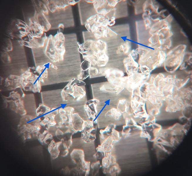
Yesterday, I visited the site on an intentionally-triggered avalanche from this past Tuesday on a steep southwest aspect at 7800' in Big Cottonwood Canyon. This avalanche ran on a layer of faceted snow sitting just above a crust. I found the snowpack in this area still very sensitive (observation). The photo below has arrows pointing to the small-grained faceted snow sitting just above a melt/freeze crust:
Although the concerns of these persistent weak layers are localized, triggering an avalanche that fails on one of these layers could produce a sizeable avalanche. Avalanches involving persistent weak layers can be triggered remotely (from a distance), as well as from lower-angled terrain. If you do travel in avalanche terrain at the low and mid elevations, you have to dig down with your shovel and determine if this weak layer is present, and assess the strength of the snowpack. I am especially concerned for buried surface hoar on sheltered northerly aspects at the low and mid elevations, and would avoid any slope steeper than 30 degrees if I found buried surface hoar present. Mark White provides an excellent observation describing how he evaluated the snowpack in the Meadow Chutes on Thursday. Notice how he describes first digging down looking for surface hoar or faceted snow, and proceeding to steeper lines only after he determined the lack of weak layers and the strength of the snowpack through careful evaluation. |
| type | aspect/elevation | characteristics |
|---|

|

|
LIKELIHOOD
 LIKELY
UNLIKELY
SIZE
 LARGE
SMALL
TREND
INCREASING DANGER
SAME
DECREASING DANGER
|
|
description
There are three other avalanche concerns to watch for today: - Loose dry snow. The past few days featured several inches of classic Wasatch 3-4% fluff. This weak snow will sluff easily on steeper aspects, and will run long distances, possibly entraining large amounts of snow. - Loose wet snow. The sun will appear for the first time in over a week, and the loose, dry snow will be reactive to any warming from the sun. Cool temperatures and light to moderate northerly winds should keep a lid on widespread wet activity, but watch for loose wet snow as the snow surface begins to warm. - Fresh wind drifts. Winds should be light at the low and mid elevations, but may gust into the 30's mph in the upper elevations. There is an abundance of loose snow available for transport, and any bump in wind speeds will create sensitive wind drifts along upper elevation ridges. Winds are also forecasted to have a northeast component, and any time I see "east" in forecasted winds, my guard goes up for possible unusual wind loading events. Don't let the bluebird skies and 5-star ski conditions cloud good judgement: evaluate slopes before jumping in, and watch for others below you. Ski slopes one at a time, and get out of the runout zone at the bottom of a run. |
 |
weather Unfortunately our string of idyllic winter days will come to an end with sunshine and warming temperatures beginning today and through the weekend. Temperatures today should remain pleasantly cool, rising to the low 20's F at 8000', and the mid teens at 10000'. Winds will be northerly, gusting into the 20's mph at the mid elevations, and 30's mph at upper elevations. Warming continues through the weekend and into early next week. Fortunately the models are showing a series of weather systems that begin to affect the region beginning late this coming week. |
general announcements
|


.jpg)