25th Annual Black Diamond Fall Fundraising Party
Thursday, September 13; 6:00-10:00 PM; Black Diamond Parking Lot
25th Annual Black Diamond Fall Fundraising Party
Thursday, September 13; 6:00-10:00 PM; Black Diamond Parking Lot
| Advisory: Salt Lake Area Mountains | Issued by Evelyn Lees for Monday - January 23, 2017 - 6:54am |
|---|

|
bottom line The avalanche danger is HIGH on mid and upper elevation wind drifted terrain, and CONSIDERABLE in all other terrain. Travel in avalanche terrain is not recommended – you need stay off of and out from under steep terrain, and avoid avalanche runout zones. What is unusual today is the weak snow at the lower elevations. While avalanches may be smaller at low elevations, debris can still pile dangerously deep terrain traps such as gullies, creek beds, and below steep road banks.
|
 |
avalanche warning THE FOREST SERVICE UTAH AVALANCHE CENTER IN SALT LAKE CITY HAS ISSUED A BACKCOUNTRY AVALANCHE WARNING. * TIMING...IN EFFECT THROUGH 6AM TUESDAY. * AFFECTED AREA...FOR THE MOUNTAINS OF NORTHERN UTAH INCLUDING THE WASATCH RANGE...BEAR RIVER RANGE...AND THE MOUNTAINS OF SOUTHEAST IDAHO. * AVALANCHE DANGER...HIGH. * REASON/IMPACTS...HEAVY DENSE SNOW COMBINED WITH STRONG WINDS HAS CREATED WIDESPREAD AREAS OF UNSTABLE SNOW AT ALL ELEVATIONS INCLUDING LOW ELEVATION TERRAIN. BOTH HUMAN TRIGGERED AND NATURAL AVALANCHES ARE LIKELY. STAY OFF OF AND OUT FROM UNDER SLOPES STEEPER THAN 30 DEGREES. |
 |
special announcement Little Cottonwood Canyon has multiple changing backcountry closures in effect, and updates will be issued all day. You need to follow @UDOTavy or us on twitter, or check the UDOT info on our home page. Check out Mark’s Blog that summarizes the past 2 days of avalanche activity. If you sign up for AmazonSmile and designate the Utah Avalanche Center as your favorite charity, they will donate a portion of everything you spend to the UAC. I doesn't cost you a penny and we'd really appreciate the help. New Date for this! Drew will be hosting the Fireside Chat at the Black Diamond store this Wednesday at 7pm. Topic: Expert Intuition in High Risk - Low Frequency Events. Best if you have a decent grasp of the different avalanche problems, but all are welcome to this informal, low key, picnic - style gathering. |
 |
current conditions Storm “number 3” has two parts, and still we’re only in the midst of the first prefrontal part. A southwesterly flow is producing periods of strong winds and heavy snow. 6 to 8” of snow has fallen overnight in the Cottonwoods and on the Park City side, with 10 to 12” in the Ogden area mountains. This isn’t Utah powder - its dense snow averaging 10 to 15%. Winds remain from the south, with variable speeds, at times averaging up to 30 to 40 mph, with gusts in the 60s across the high ridge lines. Speeds at the mid and lower elevation stations have been in the 15 to 25 mph range. Temperatures are upper teens to low 20s. |
 |
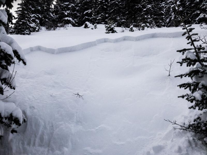
recent activity “It's a pretty easy formula: When we have avalanche activity and we get more snow and more wind, we get more avalanches.” Check out Mark’s Blog that summarizes the past 2 days of avalanche activity. Numerous new snow soft slabs were triggered yesterday, failing on low-density snow or on a layer of faceted snow that was buried last Thursday. Slides occurred in both windy upper elevation terrain and on sheltered mid to low elevation slopes. Photo: N Provo, Daly Canyon, 8000’. Photo: Mark White, Scotts Hill, 9700’.
|
| type | aspect/elevation | characteristics |
|---|

|
|
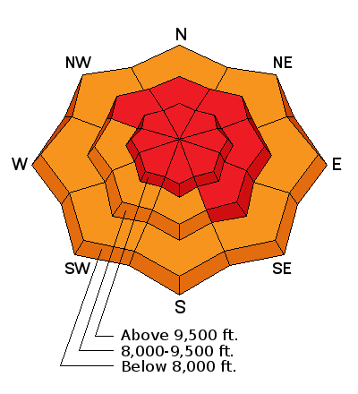
LIKELIHOOD
 LIKELY
UNLIKELY
SIZE
 LARGE
SMALL
TREND
 INCREASING DANGER
SAME
DECREASING DANGER
|
|
description
The winds are blowing the dense new snow into stiff new drifts that could be 1 to 3 feet deep. Drifts will be found both along the ridgelines and in open bowls and cross loaded around sub ridges and break overs in mid and upper elevation terrain. Smaller drifts can be found well into the lower elevation terrain. Some of these wind drifts will avalanche naturally; others are waiting for a trigger. So avoid travel below steep slopes, in addition to on steep slopes. Wind slabs and cornices are breaking back further than expected along ridge lines, even onto what looks like “flat” terrain. |
| type | aspect/elevation | characteristics |
|---|

|
|
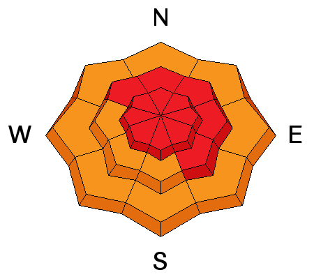
LIKELIHOOD
 LIKELY
UNLIKELY
SIZE
 LARGE
SMALL
TREND
INCREASING DANGER
SAME
DECREASING DANGER
|
|
description
Even in wind-sheltered terrain, the dense new snow will form a slab over the low-density powder of the past few days, and slides can be triggered in sheltered areas. |
| type | aspect/elevation | characteristics |
|---|

|
|
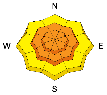
LIKELIHOOD
 LIKELY
UNLIKELY
SIZE
LARGE
SMALL
TREND
INCREASING DANGER
SAME
DECREASING DANGER
|
|
description
The persistent faceted layer we are most concerned about is the snow that was on the surface last week. It’s most widespread in more sheltered, mid to low elevation terrain. Slides breaking on this layer will only be slightly deeper than new snow slides, but more tricky. They could be triggered remotely from a distance or from below, or they can be stubborn and break above you when you’re mid slope. Also, a smaller new snow slide could step down, creating a deeper, wider. Collapsing is a sign of instability. On other aspects and elevations, there's a variety of buried thin and thick crusts, some with associated facets. These could act as weak layers or bedsurfaces, and distribution is complicated. |
 |
weather The approaching cold front is expected to cross the northern Utah mountains by around noon. Ahead of the front, strong southerly winds and snow will continue. With the passage of the cold front, expect winds to shift to the west and gradually decrease this afternoon. An additional 6 to 12” of snow is expected today, with locally higher amounts possible. 10,000’ temperatures will cool behind the front, dropping into the single digits by Tuesday morning. Cold, unstable air could produce periods of low-density snow tonight and Tuesday. |
general announcements
|