25th Annual Black Diamond Fall Fundraising Party
Thursday, September 13; 6:00-10:00 PM; Black Diamond Parking Lot
25th Annual Black Diamond Fall Fundraising Party
Thursday, September 13; 6:00-10:00 PM; Black Diamond Parking Lot
| Advisory: Salt Lake Area Mountains | Issued by Evelyn Lees for Thursday - January 19, 2017 - 6:53am |
|---|

|
bottom line The avalanche danger is mostly LOW, with a MODERATE danger on steep wind drifted upper elevation slopes. These shallow new drifts will be cracky, and can be triggered from a distance. Out of the wind affected terrain, the avalanche danger is generally LOW, though larger dry sluffs can be triggered on steep shady slopes. As always, even a small avalanche can have bad consequences if you are in extreme terrain.
|
 |
special announcement TONIGHT: Thursday, 1/19, 6 p.m. - At Snowbird's Wildflower Louge, Utah Adventure Journal hosts professional adventure skier, Brody Leven, who will talk about recent trip to the remote Tien Shan Mountains of Kazakhstan for first descents. Must be 21 years old or older and admission is FREE. More Details here. Read a great new blog post by forecaster Drew Hardesty - Shame and the Social Contract |
 |
current conditions Light snow has just started falling in the mountains as a weak storm slowly crosses the area. Ahead of the storm, the southerly winds have increased at most of the upper elevation stations - 25 to 35 mph averages, with many stations gusting to 50 mph. Speeds are much slower at most mid and lower elevation stations. Temperatures are near 20. Amid sun crusts and new wind slabs, soft faceted powder can still be found on shady, wind sheltered slopes. |
 |
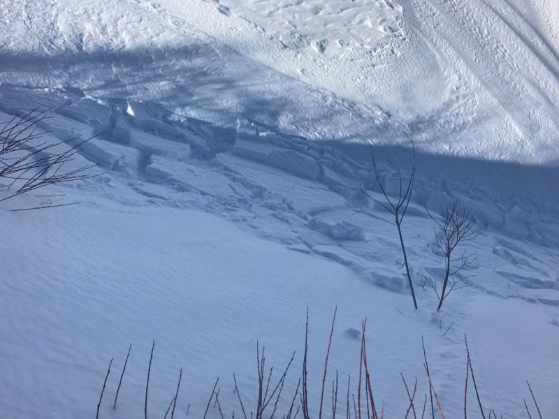
recent activity Yesterday, dry loose sluffs continued to be easy to trigger on the shady slopes and there were a few wet sluffs triggered on steep sunny slopes. These are the last of the wet loose sluffs we’ll see for a while Ogden area mountains: yesterday along one strangely windy ridge line, very sensitive wind slabs quickly formed and were easy to trigger - foreshadowing what you can expect to see through out the range today. Photo by Brian Smith of new Ogden winds slabs from yesterday.
|
| type | aspect/elevation | characteristics |
|---|

|
|
LIKELIHOOD
 LIKELY
UNLIKELY
SIZE
 LARGE
SMALL
TREND
 INCREASING DANGER
SAME
DECREASING DANGER
|
|
description
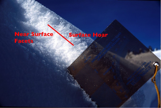
The current stronger winds are a good thing – hopefully they batter down and destroy some of our weak surface hoar. But the winds have also created sensitive new drifts of snow along ridgelines, some of which are still sitting on facets. While the new cracky drifts will be shallow, they will be easy to trigger and you may even be able to trigger them remotely from a distance. They will be large enough to take you for a ride in steep terrain. The old photo below shows similar set up to what we had yesterday on the snow surface on shady slopes – surface hoar sitting on a thick layer on small faceted snow grains. Even where winds destroy the fragile surface hoar, some of the more robust near surface facets below may persist, providing a weak layer for new wind drifts and new snow. Discovering the distribution of any preserved surface hoar or near surface facets will be important over the next few days, and observations are appreciated.
|
| type | aspect/elevation | characteristics |
|---|

|
|
LIKELIHOOD
 LIKELY
UNLIKELY
SIZE
 LARGE
SMALL
TREND
INCREASING DANGER
SAME
DECREASING DANGER
|
|
description
In wind sheltered, shady terrain, I expect some of the weak surface snow to get capped by new snow. You will continue to be able to trigger the predictable dry loose sluffs today, and they will be larger than the past few days if you’re in a spot where the new snow adds up to the forecast 3 to 6”. The sluffs will entrain snow down slope, and be large enough to catch and carry you in continuously steep terrain. |
 |
weather A weak, slow moving storm will bring snow to the mountains today and tonight. 3-6” of snow is possible today, with another 1 to 3” tonight. We should see the strongest winds this morning, with averages to 30 mph, and gusts to 50. The winds should shift to the southwest later this morning, and decrease, with average speeds below 20 mph. Temperatures will remain near 20 at 10,000’. Looking into the future, a weak storm Friday night into Saturday will bring a few more inches of snow, with a potentially stronger storm Monday into Tuesday. |
| general announcements Remember your information can save lives. If you see anything we should know about, please help us out by submitting snow and avalanche conditions. You can also call us at 801-524-5304, email by clicking HERE, or include #utavy in your tweet or Instagram. To get help in an emergency (to request a rescue) in the Wasatch, call 911. Be prepared to give your GPS coordinates or the run name. Dispatchers have a copy of the Wasatch Backcountry Ski map. Backcountry Emergencies. It outlines your step-by-step method in the event of a winter backcountry incident. If you trigger an avalanche in the backcountry, but no one is hurt and you do not need assistance, please notify the nearest ski area dispatch to avoid a needless response by rescue teams. Thanks.
EMAIL ADVISORY If you would like to get the daily advisory by email you will need to subscribe here. DAWN PATROL Hotline updated daily by 5-530am - 888-999-4019 option 8. TWITTER Updates for your mobile phone - DETAILS UDOT canyon closures: LINK TO UDOT, or on Twitter, follow @UDOTavy, @CanyonAlerts or @AltaCentral Utah Avalanche Center mobile app - Get your advisory on your iPhone along with great navigation and rescue tools. Powderbird Helicopter Skiing - Blog/itinerary for the day Lost or Found something in the backcountry? - http://nolofo.com/ To those skinning uphill at resorts: it is critical to know the resort policy on uphill travel. You can see the uphill travel policy for each resort here. Benefit the Utah Avalanche Center when you shop from Backcountry.com or REI: Click this link for Backcountry.com or this link to REI, shop, and they will donate a percent of your purchase price to the UAC. Both offer free shipping (with some conditions) so this costs you nothing! Benefit the Utah Avalanche Center when you buy or sell on ebay - set the Utah Avalanche Center as a favorite non-profit in your ebay account here and click on ebay gives when you buy or sell. You can choose to have your seller fees donated to the UAC, which doesn't cost you a penny. This information does not apply to developed ski areas or highways where avalanche control is normally done. This advisory is from the U.S.D.A. Forest Service, which is solely responsible for its content. This advisory describes general avalanche conditions and local variations always exist. |