25th Annual Black Diamond Fall Fundraising Party
Thursday, September 13; 6:00-10:00 PM; Black Diamond Parking Lot
25th Annual Black Diamond Fall Fundraising Party
Thursday, September 13; 6:00-10:00 PM; Black Diamond Parking Lot
| Advisory: Salt Lake Area Mountains | Issued by Evelyn Lees for Monday - January 16, 2017 - 6:50am |
|---|


|
bottom line The avalanche danger is MODERATE on steep wind drifted upper elevation slopes where new wind drifts will form today. Avoid pillows of rounded, smooth snow and be alert for cracking, indicating you have found a drift. Out of the wind affected terrain, the avalanche danger is generally LOW, though avalanches can still be triggered in isolated places.
|
 |
special announcement Lots of events and classes coming up - check out the calendar of events here. New blog post - Shame and the Social Contract |
 |
current conditions High pressure strengthening over northern Utah has brought clear skies and colder temperatures to the mountains this morning. Temperatures are in the teens at the mid and upper elevations, with single digits in the cold canyon bottoms. Winds have increased – averaging 5 to 10 mph at the mid elevations, with the highest peaks averaging 20 to 25 mph, gusting in the 30s. Sunny slopes sport breakable crusts, but there is excellent shallow loud powder on wind sheltered shady slopes. |
 |
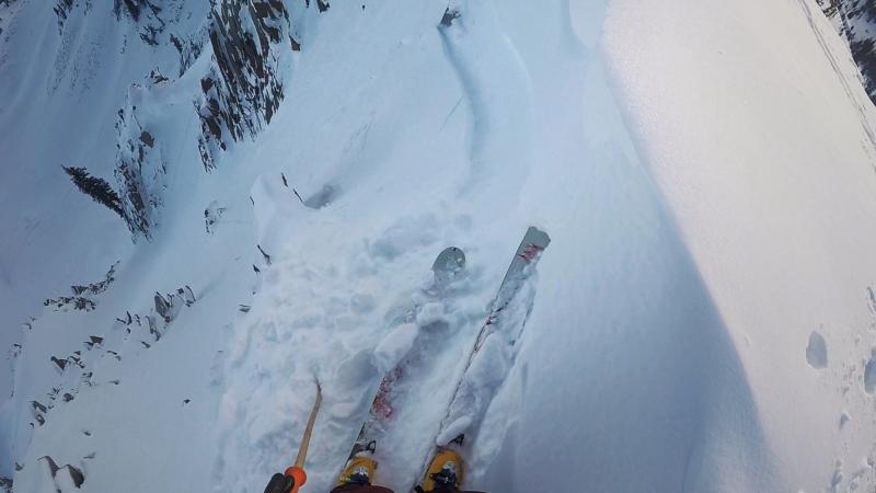
recent activity Provo area mountains: A 3-foot deep, 80-foot wide hard slab was triggered mid slope in the northwest chute of Box Elder peak. One person was carried a distance before arresting on the bed surface. This was at 10,200 feet on a northwest-facing slope. Salt Lake and Park City area mountains: Several small wind slabs were triggered, in upper Red Pine and in Wolverine Chutes. A few small dry and wet loose sluffs were also reported. Explosive work was able to pry out a 3 foot deep by 80’ wide slide to the ground on a NW facing slope at 10,600’, in a very shallow snowpack area. Travelers in Broads Fork and Mill B noted the evidence of a widespread avalanche cycle from last week. Ogden area mountains: A person released a large cornice along a high ridgeline. Box Elder slide, photo by Dan B
|
| type | aspect/elevation | characteristics |
|---|

|
|
LIKELIHOOD
 LIKELY
UNLIKELY
SIZE
 LARGE
SMALL
TREND
 INCREASING DANGER
SAME
DECREASING DANGER
|
|
description
With the increase in wind speeds at the upper elevations, new sensitive wind slabs forming along ridgelines will be the number one concern today. Identify and avoid the rounded, cracky drifts of harder snow. Even yesterday, the few old wind drifts triggered were large enough to take you for a ride in steep terrain. Left: Wolverine Chute, Jackson photo, soft slab Right: Red Pine wind slab, Dana photo
|
| type | aspect/elevation | characteristics |
|---|

|
|
LIKELIHOOD
 LIKELY
UNLIKELY
SIZE
LARGE
SMALL
TREND
 INCREASING DANGER
SAME
DECREASING DANGER
|
|
description
In general, we have a stable snow pack and a LOW avalanche danger. But avalanches can still be triggered in isolated places, and even a small slide can have bad consequences if you are in serious terrain. Evaluate steep terrain carefully. Are you above a cliff or in continuous steep terrain where you could go for a long ride? Or be pushed into trees or stopped on a bench where the snow could pile up? Huge cornices are still hanging along the ridgelines, and could break back much further than expected – onto what looks like the flat ridge line. Even if it doesn’t trigger a slide, you could be injured in the fall. Loose snow sluffs can be triggered in the weakening surface snow and are getting large enough to knock you off balance Wet loose sluffs – a few isolated wet sluffs could be triggered today in steep, sunny terrain Wild card – In very isolated places, generally in the high alpine terrain, a deeper slab avalanche could be triggered, perhaps in a shallow rocky snowpack area or on a more heavily wind drifted slope. |
 |
weather High pressure remains firmly in control, and the mountains will have beautiful clear sunny skies, while the lower canyons will be bathed in fog and stratus. The north to northeasterly winds increased at the upper elevations, and could average to 25, with gusts in the 30s. Speeds at the mid and lower elevations should remain less than 15 mph at most stations. Temperatures will be a bit cooler today – 8000’ highs near 30, 10,000’ highs warming into the low 20s. A series of storms Thursday through Monday will bring periods of snow to the mountains. |
| general announcements Remember your information can save lives. If you see anything we should know about, please help us out by submitting snow and avalanche conditions. You can also call us at 801-524-5304, email by clicking HERE, or include #utavy in your tweet or Instagram. To get help in an emergency (to request a rescue) in the Wasatch, call 911. Be prepared to give your GPS coordinates or the run name. Dispatchers have a copy of the Wasatch Backcountry Ski map. Backcountry Emergencies. It outlines your step-by-step method in the event of a winter backcountry incident. If you trigger an avalanche in the backcountry, but no one is hurt and you do not need assistance, please notify the nearest ski area dispatch to avoid a needless response by rescue teams. Thanks.
EMAIL ADVISORY If you would like to get the daily advisory by email you will need to subscribe here. DAWN PATROL Hotline updated daily by 5-530am - 888-999-4019 option 8. TWITTER Updates for your mobile phone - DETAILS UDOT canyon closures: LINK TO UDOT, or on Twitter, follow @UDOTavy, @CanyonAlerts or @AltaCentral Utah Avalanche Center mobile app - Get your advisory on your iPhone along with great navigation and rescue tools. Powderbird Helicopter Skiing - Blog/itinerary for the day Lost or Found something in the backcountry? - http://nolofo.com/ To those skinning uphill at resorts: it is critical to know the resort policy on uphill travel. You can see the uphill travel policy for each resort here. Benefit the Utah Avalanche Center when you shop from Backcountry.com or REI: Click this link for Backcountry.com or this link to REI, shop, and they will donate a percent of your purchase price to the UAC. Both offer free shipping (with some conditions) so this costs you nothing! Benefit the Utah Avalanche Center when you buy or sell on ebay - set the Utah Avalanche Center as a favorite non-profit in your ebay account here and click on ebay gives when you buy or sell. You can choose to have your seller fees donated to the UAC, which doesn't cost you a penny. This information does not apply to developed ski areas or highways where avalanche control is normally done. This advisory is from the U.S.D.A. Forest Service, which is solely responsible for its content. This advisory describes general avalanche conditions and local variations always exist. |


.jpg)