25th Annual Black Diamond Fall Fundraising Party
Thursday, September 13; 6:00-10:00 PM; Black Diamond Parking Lot
25th Annual Black Diamond Fall Fundraising Party
Thursday, September 13; 6:00-10:00 PM; Black Diamond Parking Lot
| Advisory: Salt Lake Area Mountains | Issued by Trent Meisenheimer for Tuesday - January 10, 2017 - 4:38am |
|---|

|
bottom line A rising avalanche danger this morning, will likely rise to HIGH later today. This morning the avalanche danger is rated CONSIDERABLE on all wind drifted slopes at mid and upper elevations. Avalanches can be triggered from a distance today. The danger is MODERATE at low elevations. Those without careful snowpack evaluation, cautious route-finding and conservative decision-making should avoid the backcountry today.
|
 |
avalanche warning THE FOREST SERVICE UTAH AVALANCHE CENTER IN SALT LAKE CITY HAS CONTINUED THE BACKCOUNTRY AVALANCHE WARNING. * TIMING...THROUGH 6PM WEDNESDAY * AFFECTED AREA...THE MOUNTAINS OF NORTHERN UTAH, TO INCLUDE THE WASATCH RANGE, THE BEAR RIVER RANGE AND THE MOUNTAINS OF SOUTHEAST IDAHO, THE WESTERN UINTAS, AND THE MANTI-SKYLINE PLATEAU. * AVALANCHE DANGER...THE DANGER IS CONSIDERABLE TODAY IN THE COTTONWOOD CANYONS AND PROVO MOUNTAINS. THE DANGER WILL LIKELY SPIKE AGAIN BACK TO HIGH TOMORROW. * REASON/IMPACTS...HEAVY SNOWFALL AND STRONG WINDS, COMBINED WITH RAIN ON SNOW AT THE LOWER ELEVATIONS WILL CREATE WIDESPREAD DANGEROUS AVALANCHE CONDITIONS. AVOID BEING ON OR BENEATH STEEP SLOPES. THIS WARNING DOES NOT APPLY TO SKI AREAS WHERE AVALANCHE HAZARD REDUCTION MEASURES ARE PERFORMED. |
 |
special announcement There is a backcountry closure in effect in Little Cottonwood Canyon. Utah Department Of Transportation is trying to have the canyon open by 8:00 am - Click HERE for more details. Tonight: Tuesday, January 10th in Park City, Craig Gordon will present "What you should know about current conditions and the snow pack." Click HERE for more details. |
 |
current conditions A wall of cold air and moisture came marching into the valley around the dinner hour yesterday. This cold front dropped temperatures in a hurry and most trail heads this morning have seen a 10-15 degree F. drop in temperatures. Upper elevation temperatures are in the mid teens at most stations. Winds, mainly from the west have relaxed a little in the past six hours but are beginning to increase once again ahead of another storm system. 10,000' stations are reporting 15-25 mph gusting into the upper 30's & 40's. In the past 24 hrs we have had roughly 9-12" of new snow with (1.2"-2.0" h20) scattered throughout the range. Remember, when it comes to avalanches it doesn't matter how deep the snow is, it's a function of weight. How much water (weight) has been added to the snowpack. This new snow has been right side up and dense. The dense, spongy, graupel laden snow is upright and surfy. Riding conditions on low angle slopes (less than 30 degrees) prove to be the best and safest option. Remember - to not have steeper slopes above or adjacent to you as avalanches maybe triggered from a distance today. |
 |
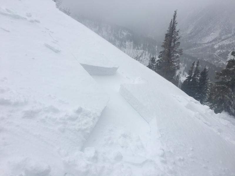
recent activity Yesterday, we experienced a natural avalanche cycle during the peak of wind and snowfall. Many backcountry travelers reported very sensitive and touchy conditions, even at mid elevations. Most avalanches were failing within the new storm snow about a foot deep and up to a hundred feet wide - deep enough to bury a person. Avalanche workers reported widespread class 2 avalanches (class 2 is large enough to catch, carry and bury a person) released with ski cuts and explosives. Some avalanches started as new snow soft slabs, that had characteristics of a wet avalanche as they ran. This is due to the high water content within the new snow. There were reports of some slides propagating wider than usual and very sensitive. Some class 3 avalanches (class 3 is large enough to bury and destroy a car, truck or break trees) were released with explosives at upper elevations on a variety of aspects in backcountry-like terrain. One very experienced snow safety worker was caught and carried while working yesterday. He was caught in an avalanche that was roughly 2-5 ft deep and at this it is unknown how wide the avalanche was. He was carried and deployed an airbag. He was not buried or injured. Pictures of a wind slab avalanche triggered yesterday in upper Little Cottonwood Canyon. Photo: Allison Conover - observation found here
|
| type | aspect/elevation | characteristics |
|---|

|
|
LIKELIHOOD
 LIKELY
UNLIKELY
SIZE
 LARGE
SMALL
TREND
 INCREASING DANGER
SAME
DECREASING DANGER
|
|
description
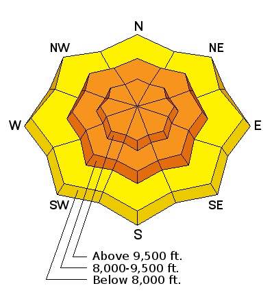
Natural and human triggered avalanches occurred yesterday. With continued strong winds and more snow, expect more avalanches. Yesterday's wind slabs will likely be covered up by last nights burst of snow making it more challenging to spot the wind drifted snow. Making matters more complicated the winds shifted from the southwest to the northwest with yesterday's cold front. This loaded a variety of new aspects and elevations. If you find your-self in upper elevation wind drifted slopes I would expect these wind drifts to be stubborn, which could give you a false sense of security. Don't forget that yesterday we had wind gusts up to 100 mph and sustained speeds in the 30's & 40's. If you trigger a wind slab it will likely be one to two feet deep and up to a couple hundred feet wide - large enough to bury you. These wind slabs may also be triggered from a distance today. CONSIDERABLE DANGER IS NO JOKE - MOST AVALANCHE FATALITIES HAPPEN WHEN THE DANGER IS RATED CONSIDERABLE. This season is shaping up to be one of the best seasons we've had in years. We just need to be patient and let this storm move through and stabilize. Travel advice - Stick to low angle slopes (less than 30 degrees in steepness) with nothing steep above or adjacent to you. Avoid avalanche run-out zones. There is great riding conditions on many low angle slopes. Those without careful snowpack evaluation, cautious route-finding and conservative decision-making should avoid the backcountry today. |
| type | aspect/elevation | characteristics |
|---|

|
|
LIKELIHOOD
 LIKELY
UNLIKELY
SIZE
LARGE
SMALL
TREND
INCREASING DANGER
SAME
DECREASING DANGER
|
|
description
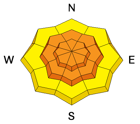
With more snow expected today and tonight, expect that avalanches can be triggered even out of the wind. New snow is especially sensitive during squalls, when there is heavy snow fall. These avalanches can be triggered well down off ridge lines. At the low elevations, the snow may not have completely cooled, and there could be weak wet snow beneath the new powder. |
| type | aspect/elevation | characteristics |
|---|

|

|
LIKELIHOOD
LIKELY
UNLIKELY
SIZE
 LARGE
SMALL
TREND
INCREASING DANGER
SAME
DECREASING DANGER
|
|
description
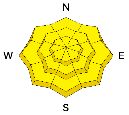
At mid to low elevations, there is a rain crust from December 16th with a layer of weak facets above it. See this observation from Mt. Aire on Saturday. This layer is on all aspects below 7500 feet. It produced persistent slab avalanches in the Provo area mountains last week (some triggered from a distance), and may have enough of a load on it now to produce avalanches in the mountains near Salt Lake City. This ice crust should be visible in a snow pit wall and is likely 2-3 feet deep depending on the area. Video from January 2nd showing some layer that has me concerned. This video shows a good representation of the layering. However all other information is out of date. This was in Mineral Fork on a NE aspect at 8300' in elevation. Click here or watch below. |
 |
weather Warming temperatures and strong westerly winds are expected today ahead of the next storm system. The northern Wasatch mountains are expected to do well both today and tonight on the southwest flow 3-6" of snow possible today. The rain/snow line will once again rise - perhaps to 6,500' later today and overnight. 8,000' temperatures will warm to near 30 today and tonight. The westerly winds will average 20-30 mph, with gusts to 60's possible for periods today and tonight. The strongest snowfall will be this evening and into the overnight hours. The cold front should pass through tomorrow afternoon, dropping temperatures once again. Finally a break later in the week, with a warming trend forecast Thursday through early next week. |
general announcements
|