25th Annual Black Diamond Fall Fundraising Party
Thursday, September 13; 6:00-10:00 PM; Black Diamond Parking Lot
25th Annual Black Diamond Fall Fundraising Party
Thursday, September 13; 6:00-10:00 PM; Black Diamond Parking Lot
| Advisory: Salt Lake Area Mountains | Issued by Mark Staples for Monday - January 9, 2017 - 6:56am |
|---|

|
bottom line More avalanches will occur today and the avalanche danger is rated HIGH at the upper elevations. The danger is CONSIDERABLE at mid elevations. At mid and low elevations, both loose wet and persistent slab avalanches are possible.
|
 |
avalanche warning THE FOREST SERVICE UTAH AVALANCHE CENTER IN SALT LAKE CITY HAS CONTINUED THE BACKCOUNTRY AVALANCHE WARNING. * TIMING...THROUGH 6PM WEDNESDAY * AFFECTED AREA...THE MOUNTAINS OF NORTHERN UTAH, TO INCLUDE THE WASATCH RANGE, THE BEAR RIVER RANGE AND THE MOUNTAINS OF SOUTHEAST IDAHO, THE WESTERN UINTAS, AND THE MANTI-SKYLINE PLATEAU. * AVALANCHE DANGER...THE DANGER IS HIGH * REASON/IMPACTS...HEAVY SNOWFALL AND STRONG WINDS, COMBINED WITH AIN ON SNOW AT THE LOWER ELEVATIONS WILL CREATE WIDESPREAD DANGEROUS AVALANCHE CONDITIONS. AVOID BEING ON OR BENEATH STEEP SLOPES. AVALANCHES RELEASING OFF STEEP ROOFS MAY BE DANGEROUS IN THE URBAN AND MOUNTAIN VALLEYS. THIS WARNING DOES NOT APPLY TO SKI AREAS WHERE AVALANCHE HAZARD REDUCTION MEASURES ARE PERFORMED. |
 |
special announcement A backcountry closure is in effect in Little Cottonwood Canyon this morning. Click HERE for details. TONIGHT: The Salt Lake City premier of The Fourth Phase from the creators of The Art of Flight will at Brewvies at 7 pm on Monday, Jan 9 as a fundraiser for the Utah Avalanche Center. For tickets and details click HERE. Tomorrow night: On Tuesday, January 10 in Park City, Craig Gordon will present "What you should know about current conditions and the snow pack". For details click HERE. |
 |
current conditions This morning it looked like a giant hair dryer had been blowing all night and melted all the snow and ice in my driveway. Similar conditions exist in the mountains where the main weather event overnight has been strong S winds and warm temperatures. The rain/snow line was above 8500 feet this morning with temperatures at many trailheads in the upper 30's F. Winds last night and this morning were averaging 30 mph from the S gusting 50-70 mph. Winds on the high peaks were reaching speeds of 90 mph. Snowfall totals aren't too impressive with an additional 4 inches of snow falling since yesterday (0.6 inches of snow water equivalent); however, it was snowing/raining this morning with heavy precipitation rates expected today. |
 |
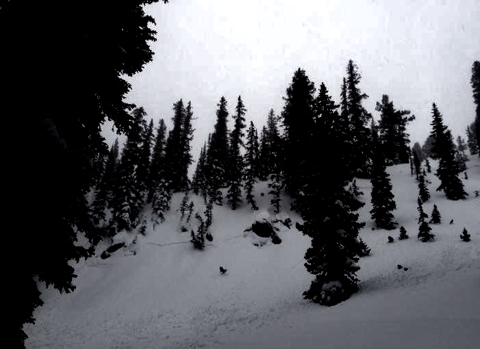
recent activity Yesterday ski patrols easily triggering many shallow avalanches with ski cuts and explosives, and reported natural avalanches in unskied, N facing terrain. In the backcountry both natural and human triggered avalanches were reported on N and NE facing slopes. These soft slab avalanches broke 6-8 inches deep. Below 9000 feet some wet loose avalanches occurred as well where rain fell on snow. In urban areas, some roofs (especially steep, metal ones) released their snow. Photo below of natural avalanche on NE facing terrain in Mineral Basin.
|
| type | aspect/elevation | characteristics |
|---|

|
|
LIKELIHOOD
 LIKELY
UNLIKELY
SIZE
 LARGE
SMALL
TREND
 INCREASING DANGER
SAME
DECREASING DANGER
|
|
description
Natural and human triggered avalanches occurred yesterday. With continued strong winds and more snow, expect more avalanches. They were breaking 6-8 inches deep yesterday and should be larger today. These slides will be most likely on slopes loaded by S winds. Non wind loaded slopes should produce human triggered slides especially later this morning during the heaviest snowfall. Cornices have been growing and may start falling and triggering slides as well. |
| type | aspect/elevation | characteristics |
|---|

|
|
LIKELIHOOD
 LIKELY
UNLIKELY
SIZE
 LARGE
SMALL
TREND
INCREASING DANGER
SAME
DECREASING DANGER
|
|
description
At mid to low eleavations, there is a rain crust from December 16th with a layer of weak facets above it. See this observation from Mt. Aire on Satuday. This layer is on all aspects below 7500 feet. It produced persistent slab avalanches in the Provo area mountains last week (some triggered from a distance), and may have enough of a load on it now to produce avalanches in the mountains near Salt Lake City. This ice crust should be visibile in a snow pit wall and is likely 2-3 feet deep depending on the area. |
| type | aspect/elevation | characteristics |
|---|

|

|
LIKELIHOOD
LIKELY
UNLIKELY
SIZE
LARGE
SMALL
TREND
 INCREASING DANGER
SAME
DECREASING DANGER
|
|
description
The peak threat from loose wet avalanches already occurred during the initial warm-up yesterday when rain fell on cold, dry snow. With more rain today at low elevations and some at mid elevations, the possibility remains for more loose, wet avalanches. These slides will mainly be a problem near terrain traps like gullies where avalanche debris can pile up deeply or in other terrain (like ice climbs) where the consequences of a small slide are severe. |
 |
weather Today's temperatures will cool very slowly with snow/rain continuing this morning. The rain/snow line should reach the valley floors by late tonight. Today, above 9000 feet an additional 5-9 inches of snow will fall (0.7-1.2 inches of snow water equivalent) and more will fall tongiht. The good news is that slowly cooling temperatures will make much lighter snow by tomorrow morning. Winds are the main avalanche issue and should continue from the S averaging 30-40 mph with gusts of 50-80 mph. |
general announcements
|