25th Annual Black Diamond Fall Fundraising Party
Thursday, September 13; 6:00-10:00 PM; Black Diamond Parking Lot
25th Annual Black Diamond Fall Fundraising Party
Thursday, September 13; 6:00-10:00 PM; Black Diamond Parking Lot
| Advisory: Salt Lake Area Mountains | Issued by Mark Staples for Thursday - January 5, 2017 - 7:33am |
|---|

|
bottom line Today with an Avalanche Warning in effect, the avalanche danger is HIGH at upper elevations and CONSIDERABLE at mid elevations due to wind slabs, storm slabs and persistent slab avalanche problems. So much new snow from this storm and one early this week has created dangerous avalanche conditions.
|
 |
avalanche warning THE FOREST SERVICE UTAH AVALANCHE CENTER IN SALT LAKE CITY HAS CONTINUED A BACKCOUNTRY AVALANCHE WARNING. * TIMING...IN EFFECT FROM 6 AM MST THIS MORNING TO 6 AM MST FRIDAY * AFFECTED AREA...FOR THE MOUNTAINS OF NORTHERN UTAH INCLUDING THE WASATCH RANGE...BEAR RIVER RANGE AND THE WESTERN UINTA MOUNTAINS. * AVALANCHE DANGER...THE AVALANCHE DANGER FOR THE WARNING AREA IS HIGH. * REASON/IMPACTS...HEAVY SNOW HAS CREATED WIDESPREAD AREAS OF UNSTABLE SNOW. BOTH HUMAN TRIGGERED AND NATURAL AVALANCHES ARE LIKELY OR OCCURRING. STAY OFF OF AND OUT FROM UNDER SLOPES STEEPER THAN 30 DEGREES. THIS WARNING DOES NOT APPLY TO SKI AREAS WHERE AVALANCHE HAZARD REDUCTION MEASURES ARE PERFORMED. |
 |
special announcement Utah Department of Transportation (UDOT) has issued a backcountry closure for avalanche control in Little Cottonwood Canyon on the north side of the road from LIsa Falls to Grizzly Gulch until 8 a.m. this morning. Please follow them on twitter and Instagram for the latest updates. You can also click the HERE for more details. The Salt Lake City premier of The Fourth Phase from the creators of The Art of Flight will at Brewvies at 7 pm on Monday, Jan 9 as a fundraiser for the Utah Avalanche Center. For tickets and details, go to https://utahavalanchecenter.org/event/fourth-phase |
 |
current conditions Temperatures have dropped into the mid teens F this morning with single digit temperatures at upper elevations. Westerly winds remain strong on the high peaks where they are blowing 40-50 mph with gusts of 60 mph. At lower ridgelines and mid elevations, wind are blowing 10 mph with gusts of 20-30 mph. This storm started early yesterday morning and is ending this morning. It started warm with lots of graupel and finished cold with some light snow; therefore, its hard to say exactly how much snow fell. It looks like Big Cottonwood received about 16 inches of snow containing 1.5 inches of water. Little Cottonwood and the Park City Ridgeline received closer to a foot of snow and about 1 inch of water. Video of Craig Gordon explaining why this storm increased the avalanche danger. |
 |
recent activity With such stormy weather yesterday, few people were able to see much terrain and spot recent avalanches. One observer along the Park City Ridgeline easily broke cornices and triggered small wind slabs. With so much snow this week and a mix of light snow, strong winds, graupel, and dense snow, I suspect there were some natural avalanches but they were not observed. |
| type | aspect/elevation | characteristics |
|---|

|

|
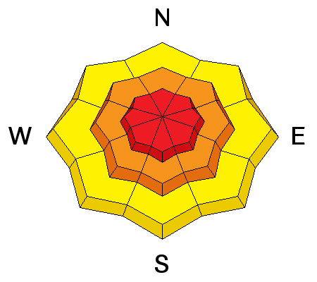
LIKELIHOOD
 LIKELY
UNLIKELY
SIZE
 LARGE
SMALL
TREND
 INCREASING DANGER
SAME
DECREASING DANGER
|
|
description
Strong westerly winds blew yesterday during the storm. Even though I think the peak instability occurred last night, I'm being conservative today with the danger rating simply based on the amount of new snow from this storm coupled with the storm from Monday/Tuesday. |
| type | aspect/elevation | characteristics |
|---|

|
|
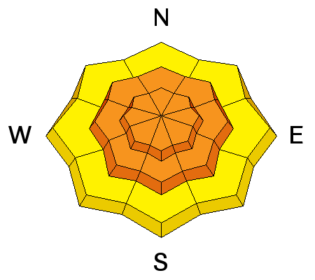
LIKELIHOOD
 LIKELY
UNLIKELY
SIZE
 LARGE
SMALL
TREND
INCREASING DANGER
SAME
DECREASING DANGER
|
|
description
Monday/Tuesday's storm was cold and produced light snow which is now capped by dense snow from this storm. Dense, cohesive snow on top of light snow is always a good recipe for avalanches. This layering may not be very obvious today because yesterdays dense snow will become more supportable today. Additionally, snow early this morning will be light and will hide this upside down layering (dense snow on top of light snow). The good news is that this type of instability can heal itself fairly quickly. |
| type | aspect/elevation | characteristics |
|---|

|
|
LIKELIHOOD
 LIKELY
UNLIKELY
SIZE
LARGE
SMALL
TREND
 INCREASING DANGER
SAME
DECREASING DANGER
|
|
description
Buried faceted layers of snow concern me and could be a longer lasting problem. With so much snow from yesterday/last night and early this week, these layers will be stressed today. In outlying areas like Mt Aiare and Lambs Canyon or other places that have a thinner snowpack, there are several faceted layers. These layers may exists in the Cottonwood Canyons but are not as widespread. Drew and his partner found several obvious weak, faceted layers in the snowpack on Monday on Mt Aire. It is worth looking for these layers no matter where you are. If you find them, give them a few days at least to adjust to the weight of the new snow. For now I don't trust them. |
 |
weather With cold air descending from the north, today shouldn't warm at all, and temperatures may even continue to drop a few more degrees. The good news is that winds should steadily decrease through the day and the sun may break through cloudy skies by afternoon. . |
general announcements
|


