25th Annual Black Diamond Fall Fundraising Party
Thursday, September 13; 6:00-10:00 PM; Black Diamond Parking Lot

25th Annual Black Diamond Fall Fundraising Party
Thursday, September 13; 6:00-10:00 PM; Black Diamond Parking Lot
| Advisory: Salt Lake Area Mountains | Issued by Evelyn Lees for Monday - January 2, 2017 - 6:49am |
|---|
 |
special announcement The Salt Lake City premier of The Fourth Phase from the creators of The Art of Flight will at Brewvies at 7 pm on Monday, Jan 9 as a fundraiser for the Utah Avalanche Center. For tickets and details, go to https://utahavalanchecenter.org/event/fourth-phase Brighton has amended their uphill travel plan. You can find it here - http://www.brightonresort.com/mountain/ski-patrol/brighton-resort-uphill-travel-plan/ |
 |
current conditions This storm could turn into a decent little refresh – as of 6 am, the Ogden, Park City and Salt Lake area mountains have received 4 to 8” of low density snow, with snow just starting to fall in the Provo area mountains. 10,000’ temperatures have dropped into the single digits. Several hours of very strong southwesterly winds preceded the cold front. Currently, the winds are from a more westerly direction, with moderate speeds in the 10 to 15 mph range, though the high peaks averaging 20 to 25 mph with gusts in the 40s. |
 |
recent activity No new avalanches were reported yesterday. |
| type | aspect/elevation | characteristics |
|---|


|


|

LIKELIHOOD
 LIKELY
UNLIKELY
SIZE
 LARGE
SMALL
TREND
 INCREASING DANGER
SAME
DECREASING DANGER
|
|
description
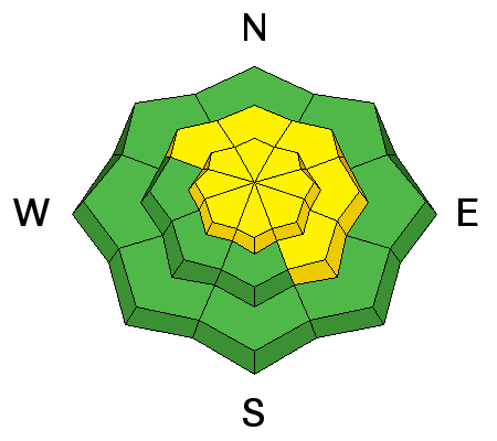
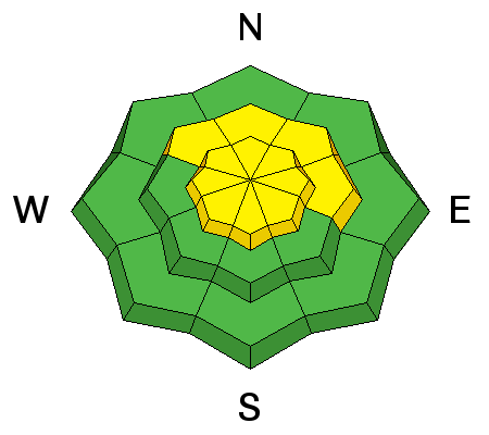
The new wind slabs will be sensitive and easy to trigger today, most widespread in upper elevation terrain and along mid elevation ridge lines. Avoid any drifts of wind blown snow on steep slopes – the drifts will be dense or hard, cracky rounded pillows of snow. Use small test slopes to gauge the sensitivity of the wind drifts. |
| type | aspect/elevation | characteristics |
|---|


|


|

LIKELIHOOD
 LIKELY
UNLIKELY
SIZE
 LARGE
SMALL
TREND
 INCREASING DANGER
SAME
DECREASING DANGER
|
|
description
Even out of the wind-affected terrain, the new snow will bond poorly to some of the old snow surfaces. All the near surface facets and surface hoar were not destroyed by the overnight winds on more sheltered, northerly facing slopes. Be prepared to trigger long running new snow sluffs and shallow soft slabs on steep slopes at the mid and upper elevations. Trigger points may be mid slope, with snow releasing above you, and remotely triggered slides are possible. Also be suspicious of the snow below cliff bands, where the early storm graupel may have pooled. This is another place it will be more likely to trigger a new snow slab. Shovel tilt test a good way to look for the buried surface hoar or near surface facets today. |
| type | aspect/elevation | characteristics |
|---|


|


|

LIKELIHOOD
 LIKELY
UNLIKELY
SIZE
 LARGE
SMALL
TREND
 INCREASING DANGER
SAME
DECREASING DANGER
|
|
description
Any of the buried faceted weak layers should still be dormant, but a smaller new snow slide might be able to trigger a deeper slide in the snowpack, especially in a shallower snowpack area. These weak layers can be found around the compass, including some southerly facing slopes with facet-crust sandwiches., and mostly at the upper elevations. |
 |
weather The cold front will continue to slowly move south today, stalling out over central Utah. There should be a lull in the snowfall this morning, especially north of I-80. But light snowfall should resume later today, and most mountain locations will get another 3 to 5” by evening. The winds will be from a westerly direction today, and average 10 to 20 mph with gusts in the 30s. The highest peaks and ridge lines will have averages to 35 mph with gusts in the 50s. 10,000’ temperatures will remain near 10 degrees, and 8,000’ temperatures in the 15 to 20 degree range. A few more inches of snow is possible late tonight and Tuesday morning. |
general announcements
|