25th Annual Black Diamond Fall Fundraising Party
Thursday, September 13; 6:00-10:00 PM; Black Diamond Parking Lot
25th Annual Black Diamond Fall Fundraising Party
Thursday, September 13; 6:00-10:00 PM; Black Diamond Parking Lot
| Advisory: Salt Lake Area Mountains | Issued by Trent Meisenheimer for Thursday - December 29, 2016 - 4:19am |
|---|

|
bottom line Today the avalanche danger is MODERATE at all upper elevations and on wind loaded mid elevation slopes. The danger is LOW in all other terrain.
|
 |
special announcement The National Avalanche Center just released this new video on the avalanche problems and how they work. This is a key aspect to mountain travel. Understanding what type of avalanche you're dealing with. |
 |
current conditions Under clear skies this morning trailhead temperatures are hovering in the low teens, while the higher elevations are in the low 20's F. Winds have finally calmed down since yesterday and 10,000' speeds are 10-15 mph gusting into the low to mid 20's generally from the west. You'll find a variety of different snow textures out and about today. However, the best powder snow will be found on mid elevation slopes that have not been effected by the relentless winds over the past few days. |
 |
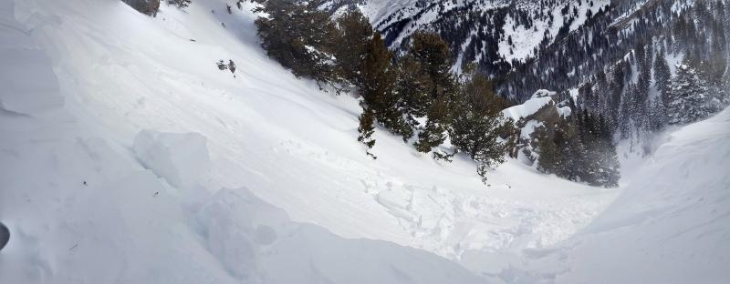
recent activity The only reported avalanches in the Central Wasatch mountains yesterday were a few wind slabs triggered by backcountry riders. One party remotely triggered a wind slab that was 16 inches deep 25 ft wide running about 250 feet down slope (picture below). Another party triggered a soft slab avalanche well off the ridge line in a cross loaded gully feature in Hideaway Park in Days Fork, this is a north facing slope at 9700' in elevation. The avalanche was 12 inches deep 75 feet wide and ran 400 feet down slope.
|
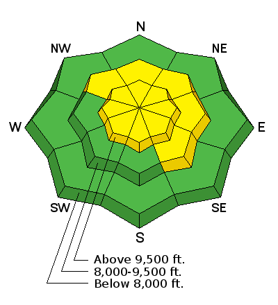
| type | aspect/elevation | characteristics |
|---|

|
|
LIKELIHOOD
 LIKELY
UNLIKELY
SIZE
 LARGE
SMALL
TREND
 INCREASING DANGER
SAME
DECREASING DANGER
|
|
description
Watch for fresh wind slabs formed by winds blowing generally from the west. These wind slabs are breaking on low density snow from the Christmas storm and can be 1-2 feet thick and up to 100 feet wide. These wind slabs could be tricky today as they will stabilize at different rates. We generally call wind slabs a manageable avalanche problem. Meaning, all you have to do is keep an eye out for snow that looks fat, rounded, pillowy, slabby and or punchy. This tells you that denser and stiffer snow sits above softer snow. It may even feel hollow and sound like a drum. Simply, observe and avoid recent drifts of wind blown snow. |
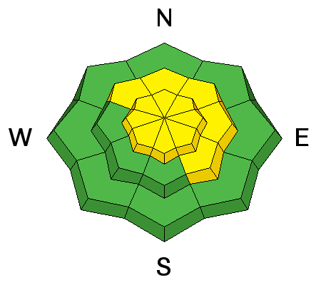
| type | aspect/elevation | characteristics |
|---|

|
|
LIKELIHOOD
 LIKELY
UNLIKELY
SIZE
 LARGE
SMALL
TREND
 INCREASING DANGER
SAME
DECREASING DANGER
|
|
description
On northwest through east aspects on upper elevations, there remains a chance of triggering a slide at the ground. While this is not likely, the additional weight of wind blown snow keeps this avalanche problem present. Faceted layers in the middle of the snowpack have mostly healed as we have not seen an avalanche break to these faceted layers for some time. |
 |
weather Today we will have clear skies and warm temperatures. Winds will remain light out of the west and southwest and should behave with speeds at upper elevations 10-15 mph with the occasional gust into the 20's. We will see high pressure and warming temperatures over the next day or two. There is another storm on tap starting late in the weekend. |
general announcements
|