25th Annual Black Diamond Fall Fundraising Party
Thursday, September 13; 6:00-10:00 PM; Black Diamond Parking Lot
25th Annual Black Diamond Fall Fundraising Party
Thursday, September 13; 6:00-10:00 PM; Black Diamond Parking Lot
| Advisory: Salt Lake Area Mountains | Issued by Drew Hardesty for Sunday - December 25, 2016 - 5:56am |
|---|


|
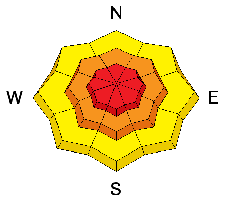
bottom line Let's keep it simple. The danger will spike to HIGH with the additional snow and wind today. The danger will be most pronounced at the mid and upper elevations on many aspects. Natural and human triggered avalanches are expected. Those without excellent avalanche and route-finding skill should avoid being in or beneath steep terrain. You can enjoy the Greatest Snow on Earth in our world class mountain resorts.
|
 |
special announcement
UDOT avalanche reduction work in Little Cottonwood Canyon this morning.
UDOT's draft backcountry closure policy can be found here and comments are welcome through January 6th. |
 |
current conditions A white Christmas indeed. Storm totals as of 5am: Little Cottonwood - 17"/1.44" Big Cottonwood - 16"/1.3" Park City ridgeline - 10-17"/0.70"-1.85" With frontal passage, temperatures are in the upper single digits to mid teens. Winds, ferocious out of the south and southeast yesterday, have veered to the west-northwest, blowing 15-20mph, gusting to 30. Skiing and riding conditions should be out of this world. Lastly, in the spirit of Christmas, remember to give a handshake, hug, or high-five to the public safety folks out there: plow drivers, UDOT and ski area workers, etc. Drive safe - |
 |
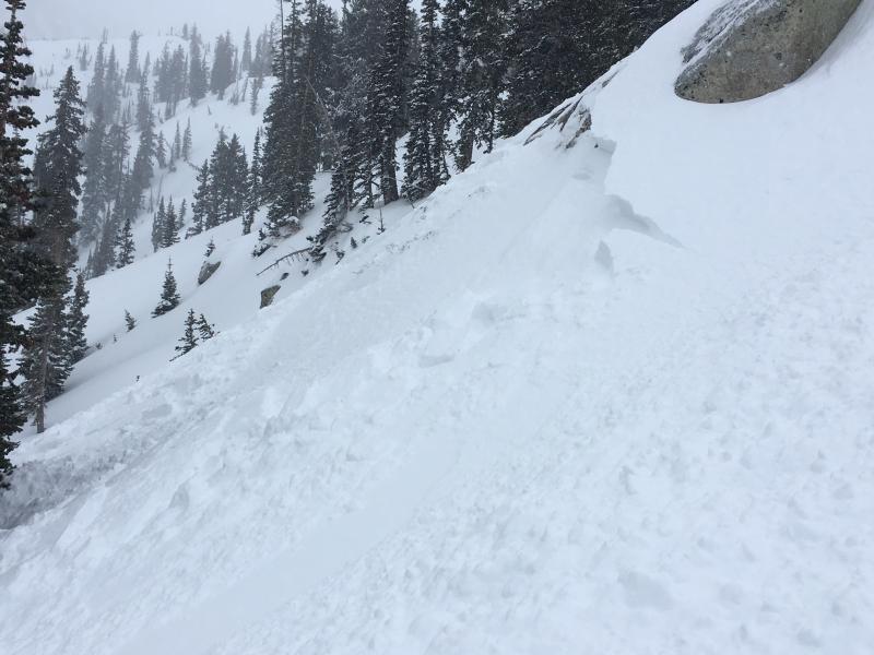
recent activity Yesterday's fierce, swirling winds littered the landscape with drifts up to 1- 2' deep. Avalanche teams and backcountry observers noted - and intentionally triggered -wind slabs on many aspects (including west to northwest aspects), in cross-loaded gullies, mid-slope break-overs, and around other terrain features. One skier unintentionally triggered and was subsequently caught and carried in a 2' deep and 30' wide hard slab pocket in Cardiff Bowl, a steep east facing slope at 10,200'. I have a new blog post on the Birthday Chutes avalanche from last Monday - #Nothing Bad Happened. Happy reading. A couple photos of wind slabs and wind-effect from Greg Gagne and Mark White, below.
|
| type | aspect/elevation | characteristics |
|---|

|
|
LIKELIHOOD
 LIKELY
UNLIKELY
SIZE
 LARGE
SMALL
TREND
 INCREASING DANGER
SAME
DECREASING DANGER
|
|
description
Plan on wind slabs on top of wind slabs. Yesterday's strong south to southeast winds littered the landscape with soft and hard drifts that haven't yet settled out. With frontal passage, the winds are now out of the west and northwest with near-perfect speeds for wind-loading. While yesterday's drifts were manageable and fairly predictable for professionals and highly experienced backcountry riders, they'll be too deep and unpredictable when you lump the two together today. Wind slabs may be up to 3'+ deep and a couple hundred feet wide. It may also be possible to trigger wind drifts at a distance during periods of heavy snowfall and drifting. Cracking and collapsing are sure-fire indicators of instability....but the lack of same will not necessarily indicate stability. Get it? Today's buried hard wind slabs may resist the standard bag of tricks as cornice drops and ski cuts can be ineffective at best, misleading at worst. Ever growing cornices should be avoided with care. Don't get suckered out to a blind edge - the arcing wind whale may calve off behind you. |
| type | aspect/elevation | characteristics |
|---|

|

|
LIKELIHOOD
LIKELY
UNLIKELY
SIZE
 LARGE
SMALL
TREND
INCREASING DANGER
SAME
DECREASING DANGER
|
|
description
The new storm snow should be quite sensitive to human interaction with natural avalanches likely during periods of high snowfall intensity. Avoid being in and below steep confined terrain where avalanche debris piles may pile up deeply. |
| type | aspect/elevation | characteristics |
|---|

|
|
LIKELIHOOD
 LIKELY
UNLIKELY
SIZE
LARGE
SMALL
TREND
INCREASING DANGER
SAME
DECREASING DANGER
|
|
description
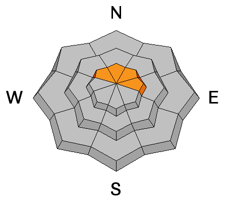
Sleeping giants tend to re-awaken during periods of high stress and heavy loading events. New snow avalanches may step down into a myriad of here-to-fore mostly stable mid and basal pack layers, resulting in a much large, potentially unsurvivable avalanche. |
 |
weather Snowfall - heavy at times - should continue throughout the day with the potential for up to an additional 6-10" in favored locations. The west to northwest winds will blow 15-20mph along the 10,000' ridgelines and gustier above that. Temperatures will be in the single digits and low teens. The storm should wind down this evening with some clearing for tomorrow into early Tuesday. A weak but potentially windy storm arrives later Tuesday into Wednesday that should deliver a few more inches of snow. |
| general announcements Remember your information can save lives. If you see anything we should know about, please help us out by submitting snow and avalanche conditions. You can also call us at 801-524-5304, email by clicking HERE, or include #utavy in your tweet or Instagram. To get help in an emergency (to request a rescue) in the Wasatch, call 911. Be prepared to give your GPS coordinates or the run name. Dispatchers have a copy of the Wasatch Backcountry Ski map. Backcountry Emergencies. It outlines your step-by-step method in the event of a winter backcountry incident. If you trigger an avalanche in the backcountry, but no one is hurt and you do not need assistance, please notify the nearest ski area dispatch to avoid a needless response by rescue teams. Thanks.
EMAIL ADVISORY If you would like to get the daily advisory by email you will need to subscribe here. DAWN PATROL Hotline updated daily by 5-530am - 888-999-4019 option 8. TWITTER Updates for your mobile phone - DETAILS UDOT canyon closures: LINK TO UDOT, or on Twitter, follow @UDOTavy, @CanyonAlerts or @AltaCentral Utah Avalanche Center mobile app - Get your advisory on your iPhone along with great navigation and rescue tools. Powderbird Helicopter Skiing - Blog/itinerary for the day Lost or Found something in the backcountry? - http://nolofo.com/ To those skinning uphill at resorts: it is critical to know the resort policy on uphill travel. You can see the uphill travel policy for each resort here. Benefit the Utah Avalanche Center when you shop from Backcountry.com or REI: Click this link for Backcountry.com or this link to REI, shop, and they will donate a percent of your purchase price to the UAC. Both offer free shipping (with some conditions) so this costs you nothing! Benefit the Utah Avalanche Center when you buy or sell on ebay - set the Utah Avalanche Center as a favorite non-profit in your ebay account here and click on ebay gives when you buy or sell. You can choose to have your seller fees donated to the UAC, which doesn't cost you a penny. This information does not apply to developed ski areas or highways where avalanche control is normally done. This advisory is from the U.S.D.A. Forest Service, which is solely responsible for its content. This advisory describes general avalanche conditions and local variations always exist. |