25th Annual Black Diamond Fall Fundraising Party
Thursday, September 13; 6:00-10:00 PM; Black Diamond Parking Lot
25th Annual Black Diamond Fall Fundraising Party
Thursday, September 13; 6:00-10:00 PM; Black Diamond Parking Lot
| Advisory: Salt Lake Area Mountains | Issued by Evelyn Lees for Saturday - December 17, 2016 - 6:36am |
|---|

|
bottom line Dangerous avalanche conditions exist in the backcountry. There is a CONSIDERABLE Avalanche Danger on all steep mid and upper elevation slopes, where human triggered avalanches are likely, and natural avalanches possible. Stay off of and out from under slopes steeper than 30 degrees, and avoid avalanche run out zones at all elevations. Careful snowpack evaluation, cautious route-finding and conservative decision making skills are necessary for backcountry travel today . Those with these avalanche skills will find great riding and lower risk on slopes less steep than 30 degrees and by avoiding avalanche runout zones, even at low elevations. If you want to ride the steep slopes, head to one of our world class resorts today.
|
 |
special announcement Little Cottonwood Canyon has backcountry closures in effect. Click just below the red UDOT square on our home page for current info. Canyons side of the Park City mountain resort will be doing control work in McDonalds and above the Daybreak lift this morning. The area is closed to all traffic. Discount lift tickets for Alta, Snowbird, Brighton, Solitude, Sundance, Snowbasin, Powder Mountain, and Beaver Mountain are now available, donated by the resorts to benefit the Utah Avalanche Center. Details and order information here. These make a great holiday gift and all proceeds go towards paying for avalanche forecasting and education! |
 |
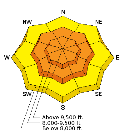
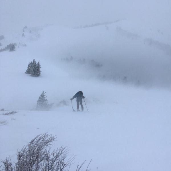
current conditions The two-part storm delivered – first warm snow, with the rain/snow line to 8,000’, followed by wild thunder and lightning as the cold front came crashing through, dropping snow levels to the valley. Upper elevations received 15 to 30” of snow, while the rain soaked mid to lower elevation snow was capped off with 2 to 10” of powder. The water content of the storm was impressive, with up to 5” in the Provo area mountains, and 4” in upper Big Cottonwood and parts of the Ogden area mountains. Currently, skies are cloudy, light snow is falling, and the northwesterly winds are light. Speeds are in the 10 to 20 mph range, with only the highest peaks gusting into the 30s. Temperatures are in the single digits just above and below zero. |
 |
recent activity Few braved the nuking weather yesterday, but a brief look into South Monitor identified a 4 foot deep, 500’ wide natural. In the Provo area mountains, a large natural avalanche cycle occurred, with slides running close to full track. Avalanche mitigation work throughout the Wasatch produced skier and explosive triggered avalanches all day long, including very large slides. Mark White photo - South Monitor
|
| type | aspect/elevation | characteristics |
|---|

|
|
LIKELIHOOD
 LIKELY
UNLIKELY
SIZE
 LARGE
SMALL
TREND
 INCREASING DANGER
SAME
DECREASING DANGER
|
|
description
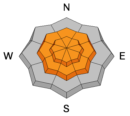
Yesterday’s strong southwesterly winds created hard slabs along the ridgelines, mid slope and in open bowls, at both the upper and mid elevations. Hard slabs are stubborn and dangerous – they often allow you get mid-slope before breaking above you. The hard cornices that formed along the ridgelines will break back further than expected today – pulling up onto what looks like a “flat” ridge line. What the winds were doing yesterday - Mark White photos
|
| type | aspect/elevation | characteristics |
|---|

|
|
LIKELIHOOD
 LIKELY
UNLIKELY
SIZE
 LARGE
SMALL
TREND
INCREASING DANGER
SAME
DECREASING DANGER
|
|
description
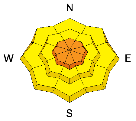
Even out of the wind affected terrain, approach steep slopes with caution. The deep new snow needs time to settle, and can be triggered on steep slopes. |
| type | aspect/elevation | characteristics |
|---|

|
|
LIKELIHOOD
 LIKELY
UNLIKELY
SIZE
LARGE
SMALL
TREND
 INCREASING DANGER
SAME
DECREASING DANGER
|
|
description
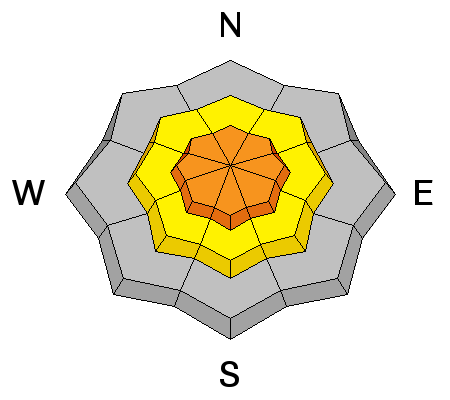
There are several layers of weak facets in our snowpack on mid and upper elevation slopes. Today, a person or a smaller new snow slide could trigger a deeper avalanche breaking on one of these weak layers, resulting in an avalanche 2 to 4 feet deep. Only in isolated places could a slide break to the ground - on an upper elevation slope facing northwest, north or northeast. |
 |
weather It will be cold today, with temperatures remaining in the single digits at 10,000’. The light northwesterly winds will average 10 to 20 mph at most locations, with even the highest peaks only gusting to 40 mph. This morning’s few snow flurries shouldn’t add up to more than an inch or two. Skies will be partly cloudy tonight, with light winds and temperatures dropping to below zero. A slow, but steady warm up into Tuesday with no new snow expected. |
| general announcements Remember your information can save lives. If you see anything we should know about, please help us out by submitting snow and avalanche conditions. You can also call us at 801-524-5304, email by clicking HERE, or include #utavy in your tweet or Instagram. To get help in an emergency (to request a rescue) in the Wasatch, call 911. Be prepared to give your GPS coordinates or the run name. Dispatchers have a copy of the Wasatch Backcountry Ski map. Backcountry Emergencies. It outlines your step-by-step method in the event of a winter backcountry incident. If you trigger an avalanche in the backcountry, but no one is hurt and you do not need assistance, please notify the nearest ski area dispatch to avoid a needless response by rescue teams. Thanks.
EMAIL ADVISORY If you would like to get the daily advisory by email you will need to subscribe here. DAWN PATROL Hotline updated daily by 5-530am - 888-999-4019 option 8. TWITTER Updates for your mobile phone - DETAILS UDOT canyon closures: LINK TO UDOT, or on Twitter, follow @UDOTavy, @CanyonAlerts or @AltaCentral Utah Avalanche Center mobile app - Get your advisory on your iPhone along with great navigation and rescue tools. Powderbird Helicopter Skiing - Blog/itinerary for the day Lost or Found something in the backcountry? - http://nolofo.com/ To those skinning uphill at resorts: it is critical to know the resort policy on uphill travel. You can see the uphill travel policy for each resort here. Benefit the Utah Avalanche Center when you shop from Backcountry.com or REI: Click this link for Backcountry.com or this link to REI, shop, and they will donate a percent of your purchase price to the UAC. Both offer free shipping (with some conditions) so this costs you nothing! Benefit the Utah Avalanche Center when you buy or sell on ebay - set the Utah Avalanche Center as a favorite non-profit in your ebay account here and click on ebay gives when you buy or sell. You can choose to have your seller fees donated to the UAC, which doesn't cost you a penny.
|


 This information does not apply to developed ski areas or highways where avalanche control is normally done. This advisory is from the U.S.D.A. Forest Service, which is solely responsible for its content. This advisory describes general avalanche conditions and local variations always exist.