25th Annual Black Diamond Fall Fundraising Party
Thursday, September 13; 6:00-10:00 PM; Black Diamond Parking Lot
25th Annual Black Diamond Fall Fundraising Party
Thursday, September 13; 6:00-10:00 PM; Black Diamond Parking Lot
| Advisory: Salt Lake Area Mountains | Issued by Drew Hardesty for Tuesday - December 13, 2016 - 6:15am |
|---|

|
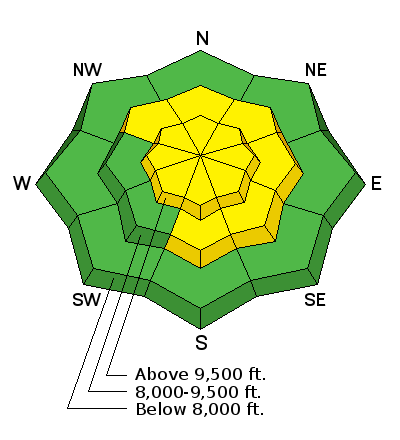
bottom line It's a complicated avalanche picture out there as not only the new storm takes its time to adjust but the pre-existing snow structure takes time to adjust. A MODERATE danger exists on many aspects and elevations today with the easterly facing terrain the most prone for avalanching. Human triggered avalanches are possible. Travel one at a time across suspect terrain, carry and know how to use your rescue gear, and consider the consequences of getting caught in a slide. A word to the wise: with great complexity and great uncertainty, great caution is required. Remember that terrain is your friend: excellent riding conditions can be found on sheltered slopes that are well less than 35 degrees in steepness with nothing steeper above.
|
 |
special announcement Fireside Chat - Tomorrow - Wednesday December 14th 7-8:30pm @ Black Diamond retail store: Matt McKee from UDOT and Evelyn Lees from the Utah Avalanche Center. Matt will review UDOT's new Avalanche Explosives Work Backcountry Closure Procedures for Provo, Little and Big Cottonwood Canyons and answer questions. Evelyn will discuss the current early winter snow pack and take a look at the concerns of buried crusts in the snowpack if there is time. Discount lift tickets for Alta, Snowbird, Brighton, Solitude, Sundance, Snowbasin, Powder Mountain, and Beaver Mountain are now available, donated by the resorts to benefit the Utah Avalanche Center. Details and order information here. These make a great holiday gift and all proceeds go towards paying for avalanche forecasting and education! Between now and Jan 15th, Whole Foods Market at Trolley Square, Sugarhouse & Cottonwood Heights will donate a dime per bag to Utah Avalanche Center when you shop there and donate your bag credit at check out. |
 |
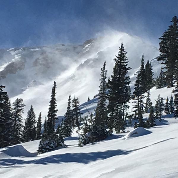
current conditions Skies are partly cloudy. Westerly winds are 15-20mph, gusting to 30. Temps are in the single digits to low teens. Winds played the spoiler by midday yesterday, wreaking havoc on much of the high, open exposed terrain and you'll find much of the sunlit and wind exposed alpine terrain littered with breakable sun and wind crusts. (Mark White photo) Unfortunately, we're not allowed to provide refunds due to inclement weather.
Snow depths sit at 35-45" at the mid-mountain snow stakes. Tyler Falk pointed out in his backcountry observation on Sunday where we sit for the season now after this last storm. See below: Central Wasatch: Mill D. BCC- 107% Brighton- 111% Snowbird-101% Parleys Summit- 143% Northern Wasatch: Ben Lomond Peak -164% Lightning Ridge- 193% Southern Wasatch: Cascade- 112% Timpanogos Divide- 98% |
 |
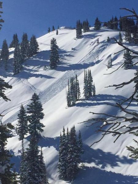
recent activity Avalanche reduction teams triggered shallow new wind drifts yesterday with both ski cuts and explosives; however in mid-BCC, a couple explosive releases pulled out two connecting pockets to create a 3-5' deep and couple hundred feet wide deep slab to the ground in high elevation unskiied northeasterly terrain. Meanwhile, just up the street on the east side of 10,420', two snowboarders undercut the steep northeast face, collapsed the slope, and triggered a pocket 2' deep and 30' wide that pulled out 100' above them. They were briefly caught and carried but managed to get off to the side without injury. (Zach Grant photo below). Fuzzy with locations or new to the area? Check out long time UAC board member Steve Achelis's webpage WBSkiing.
|
| type | aspect/elevation | characteristics |
|---|

|
|
LIKELIHOOD
 LIKELY
UNLIKELY
SIZE
 LARGE
SMALL
TREND
 INCREASING DANGER
SAME
DECREASING DANGER
|
|
description
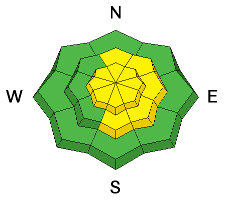
Wind drifts are likely to be stubborn but still susceptible to human provocation in steeper wind drifted terrain. They'll be more prominent on easterly facing slopes, but terrain channelling typically allows for drifts to be found on a variety of aspects, particularly at the mid elevations. Cornices should also be given a wide berth as these ridgeline whales often break well back from the apex of the ridge and have taken more than one unwary or unlucky person over the edge. |
| type | aspect/elevation | characteristics |
|---|

|
|
LIKELIHOOD
LIKELY
UNLIKELY
SIZE
 LARGE
SMALL
TREND
 INCREASING DANGER
SAME
DECREASING DANGER
|
|
description
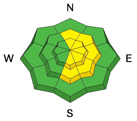
A few inches of weak faceted snow from last week's cold snap sits a couple feet deep now below the weekend's storm snow and was the culprit in yesterday's "free lesson" on the northeast side of 10,420'. This structure exists on many aspects and elevation, but is perhaps most sensitive in the steep wind drifted terrain (ie: northeast to east to southeast facing). The trends are toward stabilization, but they're called persistent weak layers for a reason. The glue on the model train needs more time to set before racing the thing down the tracks. The Fine Print: persistent weak layers , when triggered, tend to behave in unpredictable ways (see below - and thanks to Jim Conway for all the info-graphics over the years). For more info, click on the 'i' next to the Persistent Slab icon.
|
| type | aspect/elevation | characteristics |
|---|

|
|
LIKELIHOOD
 LIKELY
UNLIKELY
SIZE
 LARGE
SMALL
TREND
INCREASING DANGER
SAME
DECREASING DANGER
|
|
description
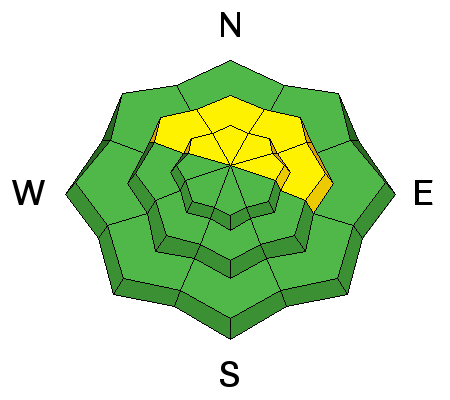
While it's unlikely, these deep slab avalanches may be triggered in thinner spots in the snowpack in isolated terrain. They may also be triggered as a "step-down'" avalanche, similar to what we saw in the Ogden area mountains on Sunday. Enough snow and wind-transported snow tipped the scales early Sunday morning in the aforementioned persistent weak layer, which then provided enough of a thump to further stress the weak snow near the ground. The trend here is also toward stabilization; however we're only a couple days removed from the significant storm that awakened this issue from its dormancy. The trouble here is what Hogarth, et al, describe as a "wicked environment", where - in the simplest terms - cause and effect isn't necessarily what you think it might be. In other words, you may ride many slopes with no issue (or ride the same slope many times with no issue) until you hit the trigger point and pull the slope down on top of you. For more on the subject of Danger in the Danger ratings, here's a blog post from a couple years ago. |
 |
weather We'll have partly cloudy skies today with increasing clouds and west to southwesterly winds ahead of the weak warm front arriving tomorrow. We may see a couple inches of snow with a potential rain/snow line later Wednesday rising to 8-8500'. Enough to just dampen the snow surface. Another storm system arrives later Thursday into Saturday that should bring another round of snow to the mountains. More details in the mountain weather forecast by mid-morning. (Look in the menu bar above). |
| general announcements Remember your information can save lives. If you see anything we should know about, please help us out by submitting snow and avalanche conditions. You can also call us at 801-524-5304, email by clicking HERE, or include #utavy in your tweet or Instagram. To get help in an emergency (to request a rescue) in the Wasatch, call 911. Be prepared to give your GPS coordinates or the run name. Dispatchers have a copy of the Wasatch Backcountry Ski map. Backcountry Emergencies. It outlines your step-by-step method in the event of a winter backcountry incident. If you trigger an avalanche in the backcountry, but no one is hurt and you do not need assistance, please notify the nearest ski area dispatch to avoid a needless response by rescue teams. Thanks.
EMAIL ADVISORY If you would like to get the daily advisory by email you will need to subscribe here. DAWN PATROL Hotline updated daily by 5-530am - 888-999-4019 option 8. TWITTER Updates for your mobile phone - DETAILS UDOT canyon closures: LINK TO UDOT, or on Twitter, follow @UDOTavy, @CanyonAlerts or @AltaCentral Utah Avalanche Center mobile app - Get your advisory on your iPhone along with great navigation and rescue tools. Powderbird Helicopter Skiing - Blog/itinerary for the day Lost or Found something in the backcountry? - http://nolofo.com/ To those skinning uphill at resorts: it is critical to know the resort policy on uphill travel. You can see the uphill travel policy for each resort here. Benefit the Utah Avalanche Center when you shop from Backcountry.com or REI: Click this link for Backcountry.com or this link to REI, shop, and they will donate a percent of your purchase price to the UAC. Both offer free shipping (with some conditions) so this costs you nothing! Benefit the Utah Avalanche Center when you buy or sell on ebay - set the Utah Avalanche Center as a favorite non-profit in your ebay account here and click on ebay gives when you buy or sell. You can choose to have your seller fees donated to the UAC, which doesn't cost you a penny.
|


 This information does not apply to developed ski areas or highways where avalanche control is normally done. This advisory is from the U.S.D.A. Forest Service, which is solely responsible for its content. This advisory describes general avalanche conditions and local variations always exist.