25th Annual Black Diamond Fall Fundraising Party
Thursday, September 13; 6:00-10:00 PM; Black Diamond Parking Lot
25th Annual Black Diamond Fall Fundraising Party
Thursday, September 13; 6:00-10:00 PM; Black Diamond Parking Lot
| Advisory: Salt Lake Area Mountains | Issued by Drew Hardesty for Thursday - November 17, 2016 - 6:13am |
|---|


|
bottom line The danger is Low and for most folks, there isn't really enough snow on which to recreate. We'll issue updates as conditions warrant.
|
 |
current conditions Left standing at the altar of storms yet again. As of 6am, upper Little Cottonwood boasts 4" of snow with .20" of "snow-water-equivalent". That's blower powder, but it's not how you build the foundation of your house. Other locations around the forecast area have a trace to 3". I suppose we may squeeze another couple of inches out the storm before it rolls on to the east. Winds are generally from the north and northwest, blowing 10-15mph along the highest, most exposed ridgelines. The temperatures make the headlines above the fold. Current temperatures are in the upper single digits at 11,000' and the low to mid teens elsewhere - a far cry from the mountain temps in the 50s Tuesday afternoon.
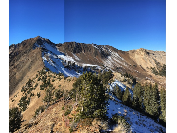
All the new snow coming in will be landing on bare, dry ground (Evelyn's photo of the Cottonwood ridgeline from Tuesday above) on all but the strictly due north and slightly northeast terrain above about 9500'. In those areas sit roughly 3-6" of very weak faceted snow - leftovers from early season storms. As you can see from Mark White's video below, this snow isn't optimal for the foundation of a house, either. If and when we finally get enough of a storm, the high northerly terrain will be most prone for avalanching. For today, one might expect a few minor sluffs in the low density powder. |
| type | aspect/elevation | characteristics |
|---|

|
|
LIKELIHOOD
 LIKELY
UNLIKELY
SIZE
 LARGE
SMALL
TREND
 INCREASING DANGER
SAME
DECREASING DANGER
|
|
description
If there's enough snow to slide upon, there's enough snow to slide. Most early seasons have close calls and near-misses, even tragic fatalities. These early season incidents are compounded by the thin early snowpack. In other words, while many accidents may not involve full burials, traumatic injury is likely as one gets dragged through the thinly veiled rocks, stumps, and deadfall. Also - remember as the storms inevitably roll in, one must treat unopened ski area terrain as having a backcountry snowpack. Please check in with the area managers and abide by the signage near the base of the ski areas. A link to policies can be found in the General Announcements, below. Also, check out our Education and Events tabs in the Menu at the top of the page - we have lots of education and free awareness classes scheduled in a location near you. |
 |
weather Looks like we may squeeze another couple - three inches out of the departing storm. Skies should become mostly cloudy and then thin to partly cloudy ahead of clearing skies for tomorrow into the weekend. Ridgetop winds today will be 10-15mph from the northwest and dying as the day wears on. Mountain temps will be in the teens, warming back to the upper 30s by the weekend. Increased southwest flow accompanying the mostly sunny skies this weekend hint at the the next Pacific storm as it builds off the coast. This storm looks to split before moving into northern Utah on Monday, though I wouldn't entirely write this thing off just yet. The models suggest a continued active pattern with another storm rolling through later Wednesday. Stay tuned. |
| general announcements Remember your information can save lives. If you see anything we should know about, please help us out by submitting snow and avalanche conditions. You can also call us at 801-524-5304, email by clicking HERE, or include #utavy in your tweet or Instagram. To get help in an emergency (to request a rescue) in the Wasatch, call 911. Be prepared to give your GPS coordinates or the run name. Dispatchers have a copy of the Wasatch Backcountry Ski map. Backcountry Emergencies. It outlines your step-by-step method in the event of a winter backcountry incident. If you trigger an avalanche in the backcountry, but no one is hurt and you do not need assistance, please notify the nearest ski area dispatch to avoid a needless response by rescue teams. Thanks.
EMAIL ADVISORY If you would like to get the daily advisory by email you will need to subscribe here. DAWN PATROL Hotline updated daily by 5-530am - 888-999-4019 option 8. TWITTER Updates for your mobile phone - DETAILS UDOT canyon closures: LINK TO UDOT, or on Twitter, follow @UDOTavy, @CanyonAlerts or @AltaCentral Utah Avalanche Center mobile app - Get your advisory on your iPhone along with great navigation and rescue tools. Powderbird Helicopter Skiing - Blog/itinerary for the day Lost or Found something in the backcountry? - http://nolofo.com/ To those skinning uphill at resorts: it is critical to know the resort policy on uphill travel. You can see the uphill travel policy for each resort here. Benefit the Utah Avalanche Center when you shop from Backcountry.com or REI: Click this link for Backcountry.com or this link to REI, shop, and they will donate a percent of your purchase price to the UAC. Both offer free shipping (with some conditions) so this costs you nothing! Benefit the Utah Avalanche Center when you buy or sell on ebay - set the Utah Avalanche Center as a favorite non-profit in your ebay account here and click on ebay gives when you buy or sell. You can choose to have your seller fees donated to the UAC, which doesn't cost you a penny.
|


 This information does not apply to developed ski areas or highways where avalanche control is normally done. This advisory is from the U.S.D.A. Forest Service, which is solely responsible for its content. This advisory describes general avalanche conditions and local variations always exist.