25th Annual Black Diamond Fall Fundraising Party
Thursday, September 13; 6:00-10:00 PM; Black Diamond Parking Lot

25th Annual Black Diamond Fall Fundraising Party
Thursday, September 13; 6:00-10:00 PM; Black Diamond Parking Lot
| Advisory: Provo Area Mountains | Issued by Evelyn Lees for Tuesday - April 10, 2018 - 7:12am |
|---|
 |
special announcement The last regular early morning forecast will be Sunday, April 17th. We will then do intermittent forecast through May 29th. The Wilderness Medicine Program at the University of Utah is surveying the knowledge of both regular and occasional backcountry users. Please provide your input through this survey. https://www.surveymonkey.com/r/AvalancheSafetySkillsSurvey |
 |
current conditions Skies are mostly clear, and temperatures are warm – in the thirties at the mid elevations, with twenties at the upper elevations and in the canyon bottoms, where the cold air has pooled. The winds have shifted to the southwest and are light, averaging 5 to10 mph at the mid elevations, and 15 to 25 mph on the highest peaks. Many slopes will be sun crusted this morning. Sadly, the trails heads in the Provo area mountains melted out long ago. It was a tough winter for low elevations snow. |
 |
recent activity The pro trio that headed down to Timp yesterday provided some much needed new information. Check out their full observation HERE. Recent activity noted:
|
| type | aspect/elevation | characteristics |
|---|


|


|

LIKELIHOOD
 LIKELY
UNLIKELY
SIZE
 LARGE
SMALL
TREND
 INCREASING DANGER
SAME
DECREASING DANGER
|
|
description
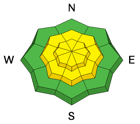
Today’s sun and warm temperatures will rapidly heat the snow and both human triggered and natural wet loose sluffs will be possible. Watch for wet or slushy snow, punchy crusts, or rollar balls as signs the snow is heating. This means it's time to move to a cooler aspect or lower angle slopes. Also avoid travel below gullies and in terrain traps once the day and snow heats. High thin clouds are forecast to move in this afternoon, which may heat the snow on the northerly facing slopes, too, especially at the mid elevations. |
| type | aspect/elevation | characteristics |
|---|


|


|

LIKELIHOOD
 LIKELY
UNLIKELY
SIZE
 LARGE
SMALL
TREND
 INCREASING DANGER
SAME
DECREASING DANGER
|
|
description
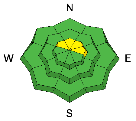
Wet slabs occurred during the rain on Saturday. The issue and the weak layers near the ground in the Provo area mountains are not gone, rather they are moslty dormant - hidden beneath a strong frozen crust. Avalanching on these deeper weak layers is unlikely. However, if you are finding wet snow beneath the crusts or as the day heats and the crusts are getting punchy, avoid steep slopes. Danger for this problem would be above 9500 at upper elevations mainly on northerlies. Mountain travel always has risks. Slide for life conditions exist on the hard, icy slopes early in the day. Wind slabs: there may be a few wind drifts along the highest ridge lines near the summits of the peaks. |
 |
weather Another beautiful morning, though the day will rapidly get too hot. Clear skies this morning, with high thin clouds moving in this afternoon. Temperatures will warm to near 60°F at 8,000’ and into the 40s at 10,000’. The southwesterly winds will average 5 to 15 mph at the mid elevations, and up to 25 mph at the upper elevations, increasing slightly this afternoon. A quick moving cold front may drop a trace to an inch of snow overnight, with a more significant storm system expected Thursday into Friday, with much colder temperatures and potentially heavy snowfall. |
| general announcements CLICK HERE FOR MORE GENERAL INFO AND FAQ The UAC has new support programs with Outdoor Research and Darn Tough. Support the UAC through your daily shopping. When you shop at Smith's, or online at Outdoor Research, REI, Backcountry.com, Darn Tough, Patagonia, NRS, Amazon, eBay a portion of your purchase will be donated to the FUAC. See our Donate Page for more details on how you can support the UAC when you shop. Benefit the Utah Avalanche Center when you buy or sell on eBay - set the Utah Avalanche Center as a favorite non-profit in your eBay account here and click on eBay gives when you buy or sell. You can choose to have your seller fees donated to the UAC, which doesn't cost you a penny This information does not apply to developed ski areas or highways where avalanche control is normally done. This advisory is from the U.S.D.A. Forest Service, which is solely responsible for its content. This advisory describes general avalanche conditions and local variations always occur. |