25th Annual Black Diamond Fall Fundraising Party
Thursday, September 13; 6:00-10:00 PM; Black Diamond Parking Lot
25th Annual Black Diamond Fall Fundraising Party
Thursday, September 13; 6:00-10:00 PM; Black Diamond Parking Lot
| Advisory: Provo Area Mountains | Issued by Trent Meisenheimer for Tuesday - April 3, 2018 - 6:06am |
|---|

|
bottom line The avalanche danger is MODERATE on upper elevation northwest through east facing terrain for triggering a deep slab avalanche 2-5' deep and up to hundreds of feet wide. Heightened avalanche conditions on specific terrain features. Evaluate snow and terrain carefully; identify features of concern. Watch for and avoid any new and old drifts of wind blown snow. There are widespread icy crusts on most aspects and elevations - so be prepared for hard, “slide for life” conditions in steep terrain. Ice axes, crampons and ski crampons may be appropriate for steep objectives.
|
 |
special announcement Special thanks to Chris Covington and Woody Woodruff for passing on life saving information from the Provo range. These two Utah Department of Transportation forecasters are top notch. |
 |
current conditions An angry inch it was.... This morning it's clear and cold with mountain temperatures bottoming out in the teens at all stations across the range. Winds continue to blow from the north/northwest with speeds 10-15 mph gusting into the 20's across the exposed ridges. Upper elevation wind chill is -11°F. Don't forget your puffy coat. A trace to 3" of new snow fell with yesterday's cold front.
|
 |
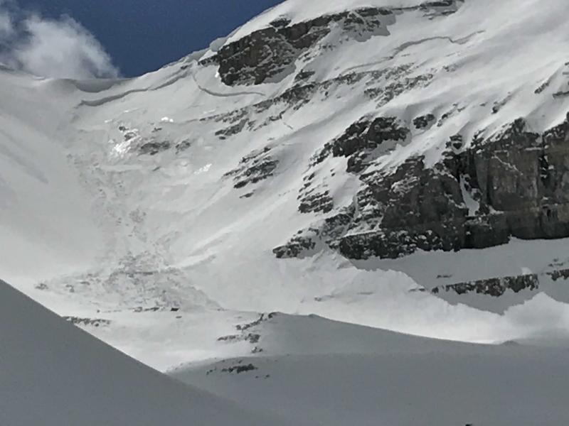
recent activity No new avalanche activity was reported from the backcountry yesterday. However, there was an impressive natural cycle that happened last week. Below is a list of recent avalanche activity provided by UDOT Forecasters John Woodruff (Woody) & Chris Covington from April 1st on Timpanogos. Find their combined observation and photos HERE.
Photo: Forecaster John Woodruff standing in the debris pile from a natural avalanche in the Provo range. |
| type | aspect/elevation | characteristics |
|---|

|
|
LIKELIHOOD
 LIKELY
UNLIKELY
SIZE
 LARGE
SMALL
TREND
 INCREASING DANGER
SAME
DECREASING DANGER
|
|
description
It might not be the year for big spring objectives in the Provo range. The biggest clue to avalanches is other avalanches - as seen from the list of recent avalanche activity the Provo range remains active. This is mainly due to it receiving less snowfall in the early months of winter, making it more shallow than it's northerly neighbor in the Central Wasatch. The are two layers of concern: First, is the weak faceted snow buried just underneath the February 18th dust layer. It's easy to find - dig down 2.5' in the snowpack and identify a dirty stripe of snow, just below that is a layer of weak faceted snow. The second layer, is found just above the ground - we call it depth hoar, which is a fancy name for larger grained faceted snow. In either case the avalanche you trigger would likely be unsurvivable. It's best to avoid any and all steep northerly facing terrain. Remember, when dealing with faceted snow you can trigger avalanches from a distance. Walking beneath large steep terrain is the same as being on the slope. It's just like walking up to a large pile of wood and pulling out the bottom log and having the entire pile come crashing down on you. If you're going to travel in the Provo range be sure to read the thoughts from UDOT forecasters found HERE. Photo: Large natural avalanche on Timpanogos by UDOT forecasters.
|
| type | aspect/elevation | characteristics |
|---|

|

|
LIKELIHOOD
LIKELY
UNLIKELY
SIZE
 LARGE
SMALL
TREND
 INCREASING DANGER
SAME
DECREASING DANGER
|
|
description
New wind drifted snow has dotted the upper elevations with shallow wind drifts and sensitive wind slabs. These new wind slabs will be small and failing within the upper few inches of the snowpack. I would expect these to be sensitive to the weight of a rider this morning. Shallow drifts of wind blown snow can be very consequential if you're in extreme terrain where even a small avalanche can have disastrous consequences. Be on the lookout and avoid sensitive drifts of wind blown snow. There is also a chance of triggering old, harder and more stubborn windslabs that have been lingering throughout the Provo range - it's evident from the large windslab that was reported yesterday from UDOT forecasters. It was 60' wide and 2' deep running a long distance due to the steep terrain. Be on the lookout for hard stiff snow and avoid being on or underneath it. |
 |
weather It will be a spectacular day to be in the mountains today with sunny skies and cold temperatures. Northerly winds will remain brisk with speeds of 10-15 mph at upper elevations. Temperatures remain cold topping out in the upper 20's to low 30's at 9,000'. Tonight we will have increasing clouds under a west/southwest flow as a series of small weak bands ebb and flow over the mountains for the next few days. None of these bands look to be impressive. However, an inch here and there can really improve the riding. This weekends storm continues to look like a good chance of snow Saturday into Sunday. Monday looks to be a sunny powder day and might be a good day to call in sick. |
| general announcements CLICK HERE FOR MORE GENERAL INFO AND FAQ The UAC has new support programs with Outdoor Research and Darn Tough. Support the UAC through your daily shopping. When you shop at Smith's, or online at Outdoor Research, REI, Backcountry.com, Darn Tough, Patagonia, NRS, Amazon, eBay a portion of your purchase will be donated to the FUAC. See our Donate Page for more details on how you can support the UAC when you shop. Benefit the Utah Avalanche Center when you buy or sell on eBay - set the Utah Avalanche Center as a favorite non-profit in your eBay account here and click on eBay gives when you buy or sell. You can choose to have your seller fees donated to the UAC, which doesn't cost you a penny This information does not apply to developed ski areas or highways where avalanche control is normally done. This advisory is from the U.S.D.A. Forest Service, which is solely responsible for its content. This advisory describes general avalanche conditions and local variations always occur. |