25th Annual Black Diamond Fall Fundraising Party
Thursday, September 13; 6:00-10:00 PM; Black Diamond Parking Lot
25th Annual Black Diamond Fall Fundraising Party
Thursday, September 13; 6:00-10:00 PM; Black Diamond Parking Lot
| Advisory: Provo Area Mountains | Issued by Evelyn Lees for Monday - March 26, 2018 - 6:44am |
|---|


|
bottom line The avalanche danger is MODERATE at the mid and upper elevations, especially on the northerly through easterly facing slopes. Shallow wind drifts, sluffs and new snow soft slabs can be triggered on steep slopes. Even a small slide can be serious in radical terrain, and the Provo area mountains have plenty of that. There remains an isolated chance of triggering a Deep Slab avalanche 2 to 5 feet deep on northerly through easterly facing slopes at the upper elevations. Slopes that are rocky or have a shallower snowpack are most suspect, especially in terrain that has slid one or more times this year.
|
 |
special announcement Only 1 more week to support the UAC when you shop at Whole Foods. The Whole Foods Bag Donation ends March 31. When you bring your own bags to Whole Foods in Sugar House, Trolley Square, and Cottonwood Heights you can choose to have the UAC be the recipient of your 10 cent bag credit. The UAC Marketplace is still open. Our online marketplace still has deals on skis, packs, airbag packs, beacons, snowshoes, soft goods and much more. |
 |
current conditions The cooling trend continues – with wintery temperatures in the teens and single digits this morning in the Provo area mountains. Winds are currently from the northwest and light – averaging less than 10 mph at most stations, and 15 to 20 mph at the 11,000’ level to the north. Light snow is still falling in the mountains, and the hoped for “refresh” is still in progress…24 hour snow totals are currently 2 to 4” in the Provo area mountains, 1 to 4” in the SLC and PC area mountains and 2 to 8” in the Ogden area mountains. There are supportable crusts beneath the new snow on most aspects and elevations, with upper elevation northerly facing slopes holding the best of the shallow, cold dry snow. The icy crusts will not soften for the next few days, so be prepared for hard, “slide for life” conditions on many aspects in steep terrain. |
 |
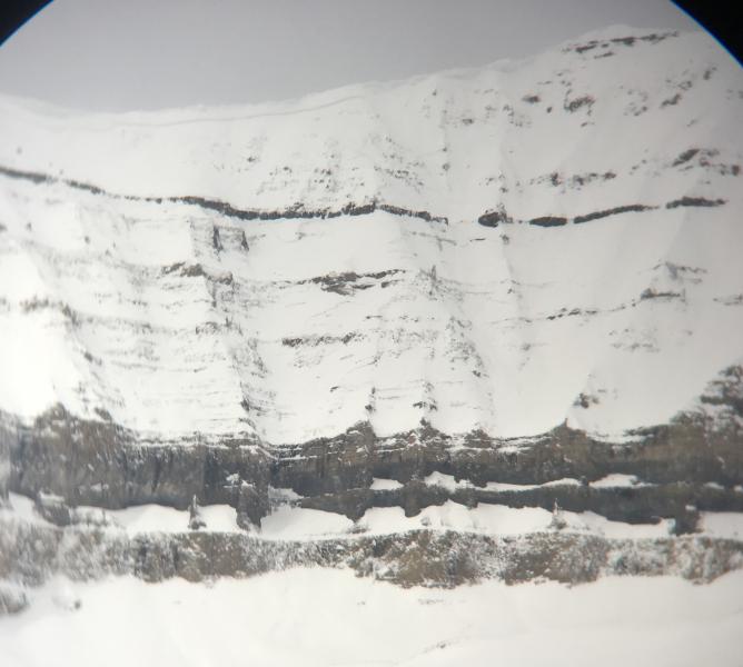
recent activity No new avalanches were reported yesterday. A large avalanches was intentionally triggered Saturday morning by UDOT in Provo Canyon in the Slide Canyon drainage. It started at 10,400 feet as a dry slab avalanche and ran nearly 4000 feet vertical becoming wet as it descended. Recent Provo observations: 03/24/2018 Observation: UFO Bowls Provo region Hardesty, Wilson 03/23/2018 Avalanche: Slide Canyon Provo region Woody 03/22/2018 Avalanche: Cascade Cirque Provo region Woody Slide Canyon Avalanche, Woody
|
| type | aspect/elevation | characteristics |
|---|

|
|
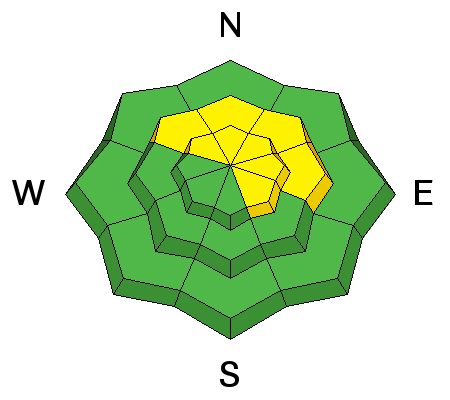
LIKELIHOOD
 LIKELY
UNLIKELY
SIZE
 LARGE
SMALL
TREND
 INCREASING DANGER
SAME
DECREASING DANGER
|
|
description
Sluffs, shallow wind slabs and new snow slabs can be triggered today on steep slopes, especially at the upper elevations in wind affected terrain. Friday’s loose graupel sitting above the hard crusts could be a weak layer for the slab avalanches. While these slides would be shallow, the terrain you are in will make a difference – even a small slide is serious if a ride would carry you off a cliff, into trees or down a long, icy slope. Greg Gagne and Mark Johnston made a great video showing the “graupel above the crust” layering in the Salt Lake area mountains. Perhaps this same layering exists in the Provo area mountains. |
| type | aspect/elevation | characteristics |
|---|

|
|
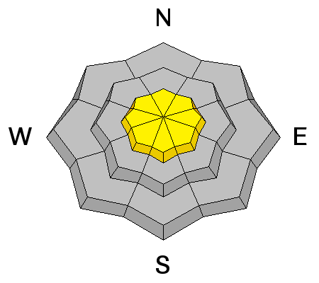
LIKELIHOOD
LIKELY
UNLIKELY
SIZE
 LARGE
SMALL
TREND
INCREASING DANGER
SAME
DECREASING DANGER
|
|
description
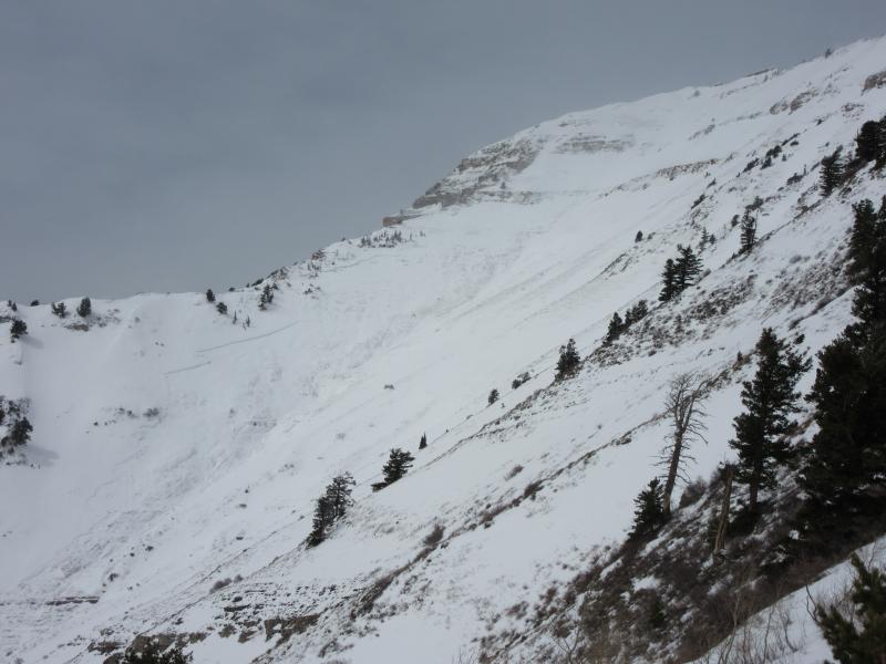
At upper elevations it is still possible to trigger an avalanche breaking on a deeper weak facet layer. Slopes with a shallower snow pack are most suspect – including those that have slid one or more times this year or are steep and rocky. It’s a low probability of triggering a slide, but high consequences if you do. The snowpack in the Provo area mountains is much weaker than it is just a little further north. Friday's avalanche triggered by UDOT is a red flag that large avalanches are still possible. Wind slab? Deep slab? Drew Hardesty photo of natural avalanche with wide propagation below Cascade Cirque ridgeline
|
 |
weather The coldest air of the storm system is moving across the Wasatch mountains this morning, and light snow flurries are still occurring. Another trace to 2” of snow is possible this morning. Then, winds will shift to the north, cutting off the snow, and skies will become partly cloudy by this afternoon. Wind speeds are forecast to remain light, averaging below 15 mph at the mid elevations, and 20 mph at the highest elevations. Temperatures will only warm into the mid to upper 20s. The upcoming week looks quiet, with a slow warming trend, though there is a chance for a few snow showers Tuesday. |
| general announcements CLICK HERE FOR MORE GENERAL INFO AND FAQ The UAC has new support programs with Outdoor Research and Darn Tough. Support the UAC through your daily shopping. When you shop at Smith's, or online at Outdoor Research, REI, Backcountry.com, Darn Tough, Patagonia, NRS, Amazon, eBay a portion of your purchase will be donated to the FUAC. See our Donate Page for more details on how you can support the UAC when you shop. Benefit the Utah Avalanche Center when you buy or sell on eBay - set the Utah Avalanche Center as a favorite non-profit in your eBay account here and click on eBay gives when you buy or sell. You can choose to have your seller fees donated to the UAC, which doesn't cost you a penny This information does not apply to developed ski areas or highways where avalanche control is normally done. This advisory is from the U.S.D.A. Forest Service, which is solely responsible for its content. This advisory describes general avalanche conditions and local variations always occur. |