25th Annual Black Diamond Fall Fundraising Party
Thursday, September 13; 6:00-10:00 PM; Black Diamond Parking Lot
25th Annual Black Diamond Fall Fundraising Party
Thursday, September 13; 6:00-10:00 PM; Black Diamond Parking Lot
| Advisory: Provo Area Mountains | Issued by Trent Meisenheimer for Monday - March 12, 2018 - 6:59am |
|---|

|
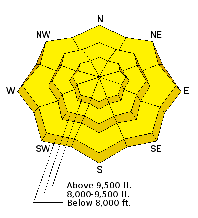
bottom line Areas of MODERATE hazard exists for triggering a persistent slab avalanches on slopes facing west to north through southeast at the mid and upper elevations. These slides may be triggered remotely, and may break out several hundred feet wide. Warming temperatures today will also lead to a period of wet loose activity on solar aspects, as well as all around the compass at lower elevations. SAFER riding conditions can be found on low angle northerly terrain with no overhead hazard. ROOF-ALANCHES are likely and have resulted in fatalities in years past.
|
 |
special announcement
|
 |
current conditions Under partly cloudy skies it should be a beautiful sunrise - Above 9,000' overnight temperatures hovered around freezing 32°F. Below 9,000' temperatures are above 32°F. Winds are calm, generally from the south and west, with even the highest elevation anemometers hardly spinning. Overnight temperatures just barely dropped below freezing so you can expect a shallow re-freeze of the snowpack surface and many of the crusted aspects will warm and soften quickly today. Upper elevation northerly facing slopes still hold dry soft snow. |
 |
recent activity Warming temperatures this past week led to a significant avalanche cycle in the Provo mountains over the past several days.
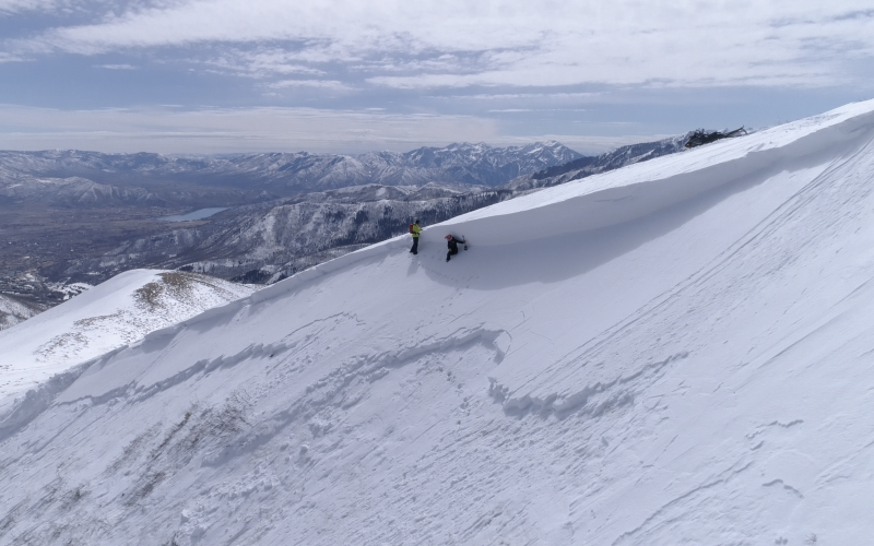
In the central Wasatch another slab avalanche was triggered yesterday by a snowmobiler in the Guardsman's Pass area. It was on a SE facing slope at 9500' in elevation. This avalanche failed initially as a wind slab and quickly stepped down to the ground. It was 150' wide, and up to 6' deep, running 500' downslope. Nobody caught. (see pic below). Photo: Andrew Nassetta - Yesterday's sled triggered slab avalanche from Guardsman area.
|
| type | aspect/elevation | characteristics |
|---|

|
|
LIKELIHOOD
 LIKELY
UNLIKELY
SIZE
 LARGE
SMALL
TREND
 INCREASING DANGER
SAME
DECREASING DANGER
|
|
description
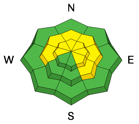
The weak faceted layers that formed this winter remain widespread in the Provo area mountains. The Provo mountains have some of the shallowest and weakest snow in northern Utah. Some of the steep slopes are just waiting for a trigger – and which slopes will slide are variable and unpredictable, but steep mid and upper elevations slopes facing northwest thorough southeasterly are the bulls eye terrain. Especially avoid steep, complex terrain with break overs, shallow rocky spots with a thin snowpack and cliffs and be aware of changes in aspect. Photo: (Meisenheimer) - Saturday's deep slab avalanche in Guardsman's Pass area, SLC mountains. This is a good example of the type of avalanche you could expect in Provo.
|
| type | aspect/elevation | characteristics |
|---|

|
|
LIKELIHOOD
 LIKELY
UNLIKELY
SIZE
 LARGE
SMALL
TREND
 INCREASING DANGER
SAME
DECREASING DANGER
|
|
description
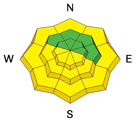
Wet Loose: As the temperatures warm into the 30s and 40s today, the snow will once again become wet and sloppy. Rider triggered or natural wet loose avalanches will be possible on all aspects and elevations except the mid and upper northerly facing slopes. This is an easy problem to avoid. When the snow surface becomes damp or you start seeing roller balls cascading down from above - it's time to change to a cooler (shady) aspect, or go home. Cornices: have softened and are sensitive, often breaking back further than expected, on what looks like flat terrain. So give them a wide berth and avoid travel below them. Roof-avalanches: Buildings are starting to shed their winter snow, so look up and avoid travel below steep roofs. |
 |
weather Partly to mostly cloudy skies and warming temperatures are on tap for today. Mountain temperatures will climb into the 30's and 40's. Winds will remain from the south and west blowing 5-15 mph at the upper elevations. The warming trend will continue into Wednesday, with a chance for mountain snow and cooler temperatures late in the week. |
| general announcements CLICK HERE FOR MORE GENERAL INFO AND FAQ The UAC has new support programs with Outdoor Research and Darn Tough. Support the UAC through your daily shopping. When you shop at Smith's, or online at Outdoor Research, REI, Backcountry.com, Darn Tough, Patagonia, NRS, Amazon, eBay a portion of your purchase will be donated to the FUAC. See our Donate Page for more details on how you can support the UAC when you shop. Benefit the Utah Avalanche Center when you buy or sell on eBay - set the Utah Avalanche Center as a favorite non-profit in your eBay account here and click on eBay gives when you buy or sell. You can choose to have your seller fees donated to the UAC, which doesn't cost you a penny This information does not apply to developed ski areas or highways where avalanche control is normally done. This advisory is from the U.S.D.A. Forest Service, which is solely responsible for its content. This advisory describes general avalanche conditions and local variations always occur. |


 We Need Your Help With Social Media