25th Annual Black Diamond Fall Fundraising Party
Thursday, September 13; 6:00-10:00 PM; Black Diamond Parking Lot
25th Annual Black Diamond Fall Fundraising Party
Thursday, September 13; 6:00-10:00 PM; Black Diamond Parking Lot
| Advisory: Provo Area Mountains | Issued by Drew Hardesty for Wednesday - February 21, 2018 - 7:41am |
|---|

|
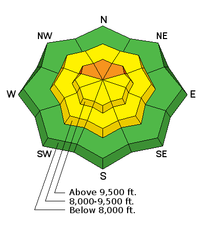
bottom line Areas of CONSIDERABLE danger exist in localized terrain. The most pronounced danger for human triggered slides 1-3' deep will be on steep northwest to northeast facing slopes with the most recent snow and wind drifting.
|
 |
special announcement We have discount lift tickets for Alta, Snowbird, Brighton, Solitude, Snowbasin,and Beaver Mountain. Details and order information here. All proceeds from these go towards paying for avalanche forecasting and education! |
 |
current conditions Skies are partly cloudy with temps in the single digits. Winds are generally less than 10mph from the southwest. Wind chill temperatures are -12°F along the ridgelines. Snow depths sit at 30-45" in the Provo mountains after Monday's storm of 12" or so. Riding conditions have greatly improved. |
 |
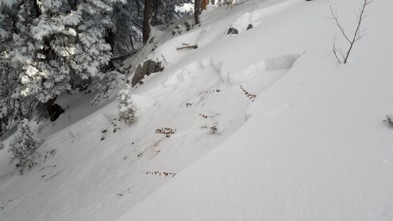
recent activity Thanks for the report. A touring party in the Provo mountains experienced collapsing yesterday and remotely triggered a foot deep and 15' wide avalanche into faceted snow on a northeast facing slope at 9500'.
|
| type | aspect/elevation | characteristics |
|---|

|

|
LIKELIHOOD
 LIKELY
UNLIKELY
SIZE
 LARGE
SMALL
TREND
 INCREASING DANGER
SAME
DECREASING DANGER
|
|
description
Collapsing, cracking, and avalanches (all noted yesterday) are sure signs of instability and avalanche conditions. Old weak snow has been stressed by additonal snow and wind over the past week, putting it on edge and waiting for a trigger. These suspect avalanche conditions are most pronounced on steep northwest to northeast facing slopes, but not limited to them. Remember that these slides may be triggered from a distance and even from below.
|
| type | aspect/elevation | characteristics |
|---|

|
|
LIKELIHOOD
 LIKELY
UNLIKELY
SIZE
 LARGE
SMALL
TREND
 INCREASING DANGER
SAME
DECREASING DANGER
|
|
description
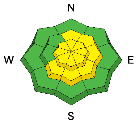
Lingering wind slabs may be found in the high alpine terrain, lee of terrain features, and potentially in the open exposed bowls and slopes. These should respond well to ski cuts and cornice drops and be 12-18" deep in localized terrain. |
 |
weather We'll see increasing clouds with the first of many generally weak weather systems on tap for northern Utah. For today, winds will be from the south and southwest at 10-15mph. Temps will generally remain in the freezer for awhile...today they'll be in the single digits up high and the low teens at the mid-elevations. Saturday night into Sunday holds the best promise for additional snowfall. |
| general announcements CLICK HERE FOR MORE GENERAL INFO AND FAQ The UAC has new support programs with Outdoor Research and Darn Tough. Support the UAC through your daily shopping. When you shop at Smith's, or online at Outdoor Research, REI, Backcountry.com, Darn Tough, Patagonia, NRS, Amazon, eBay a portion of your purchase will be donated to the FUAC. See our Donate Page for more details on how you can support the UAC when you shop. Benefit the Utah Avalanche Center when you buy or sell on eBay - set the Utah Avalanche Center as a favorite non-profit in your eBay account here and click on eBay gives when you buy or sell. You can choose to have your seller fees donated to the UAC, which doesn't cost you a penny This information does not apply to developed ski areas or highways where avalanche control is normally done. This advisory is from the U.S.D.A. Forest Service, which is solely responsible for its content. This advisory describes general avalanche conditions and local variations always occur. |