25th Annual Black Diamond Fall Fundraising Party
Thursday, September 13; 6:00-10:00 PM; Black Diamond Parking Lot
25th Annual Black Diamond Fall Fundraising Party
Thursday, September 13; 6:00-10:00 PM; Black Diamond Parking Lot
| Advisory: Provo Area Mountains | Issued by Trent Meisenheimer for Tuesday - February 28, 2017 - 7:02am |
|---|

|
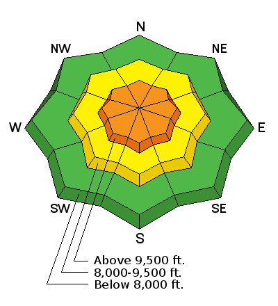
bottom line The avalanche danger is CONSIDERABLE for wind slabs at upper elevation wind loaded slopes. Lots of low density snow is available for transport and will create dangerous avalanche conditions this morning and afternoon as the winds increase. Out of the wind and at mid to low elevations you'll find a MODERATE avalanche danger for loose dry and soft storm slab avalanches. Cornices are huge and will break back further than expected. IF THE WINDS PICK UP WHERE YOU ARE, THE AVALANCHE DANGER WILL INSTANTLY RISE TO CONSIDERABLE. Quickly get out of the wind drifted terrain by heading to a lower elevation or a different aspect.
|
 |
current conditions A classic Utah cold front came sweeping across the valley yesterday delivering an impressive 8-15" (0.78-1.11'' h20) inches of new snow in the past 24hrs. I can still hear my dad and his old friends in the background of my mind talking about the good old days. You know - when it used to snow - with fixed gripped lifts, no waiting in lines, no split-boards, skinny skis (210's for men), the Chuting Gallery wasn't even written yet. Oh the good old days! Loving the classic Utah cold fronts... Clouds will quickly fill in this morning as another small system brings snow showers to the mountains. Current temperatures are cold with 10,000' stations in the single digits. Winds are calm and out of the NW with speeds of 5-15 mph with gusts into the low 20's at 10,000'. |
 |
recent activity The Provo range went through a natural avalanche cycle yesterday during the high precipitation rates where long running new snow avalanches moved with ease. Backcountry riders reported that slope cuts easily produced long running loose dry avalanches all confined to the new snow. Avalanche control teams also confirmed that loose dry avalanches were running long distances and some deep enough to bury a person. |
| type | aspect/elevation | characteristics |
|---|

|

|
LIKELIHOOD
 LIKELY
UNLIKELY
SIZE
 LARGE
SMALL
TREND
 INCREASING DANGER
SAME
DECREASING DANGER
|
|
description
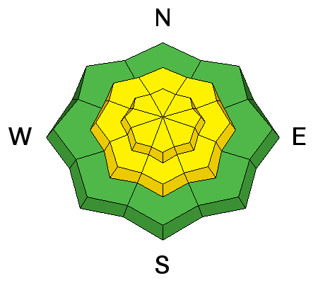
With up to 24" inches of light fluffy blower pow, it's hard not to imagine wind slabs off the higher and more exposed terrain. This morning and overnight the winds were generally calm out of the northwest. However, we have another small system moving in this morning that will likely bump wind speeds out of the west. There is plenty of new snow for even the smallest amount of wind to grab and deposit fresh drifts onto the lee aspects. Keep in mind that conditions could change with the blink of an eye if winds increase. Hot tip: lose the wind and lose the danger. Out of the wind zone slab avalanches shouldn't be a problem and you can switch your focus to a more predictable avalanche problem. See loose dry below. |
| type | aspect/elevation | characteristics |
|---|

|
|
LIKELIHOOD
 LIKELY
UNLIKELY
SIZE
LARGE
SMALL
TREND
 INCREASING DANGER
SAME
DECREASING DANGER
|
|
description
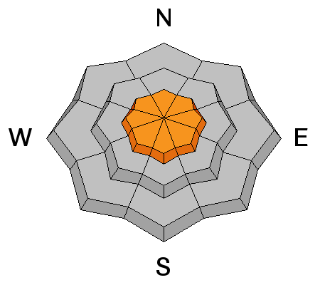
Riders will be able to trigger loose dry avalanches on steep slopes today. Once these sluffs get going, they can run fast and far, especially in continuously steep confined terrain. Most of the sluffs will be within the storm snow, but on southerly facing slopes and at the lower elevations they could run on the hard ice crusts beneath, giving them that extra distance and bulk. These loose dry avalanches could be large enough to catch, carry and bury a person.
|
| type | aspect/elevation | characteristics |
|---|

|
|
LIKELIHOOD
LIKELY
UNLIKELY
SIZE
 LARGE
SMALL
TREND
INCREASING DANGER
SAME
DECREASING DANGER
|
|
description
It's hard to predict when or where cornices will break. However, there are a couple things we know:
|
 |
weather Clouds will start filling in this morning as another small cold front pushes through northern Utah. It will remain cold today with upper elevation temperatures barely climbing into the teens before dipping back down into the single digits tonight. Westerly winds are forecasted to increase ahead of this small system this morning and into the afternoon. You can expect upper elevations to see wind speeds of 15-25 mph with gusts into the 30's. Mid elevations will see speeds in the 10-20 mph range with the occasional gust into the 20's. This system will likely bring 2-4" of low density snow by the dinner hour. |
general announcements
|


