25th Annual Black Diamond Fall Fundraising Party
Thursday, September 13; 6:00-10:00 PM; Black Diamond Parking Lot

25th Annual Black Diamond Fall Fundraising Party
Thursday, September 13; 6:00-10:00 PM; Black Diamond Parking Lot
| Advisory: Provo Area Mountains | Issued by Drew Hardesty for Saturday - January 21, 2017 - 7:16am |
|---|
 |
special announcement If you sign up for AmazonSmile and designate the Utah Avalanche Center as your favorite charity, they will donate a portion of everything you spend to the UAC. I doesn't cost you a penny and we'd really appreciate the help. I'll be hosting the Fireside Chat at the Black Diamond store in Salt Lake this Thursday at 7pm. Topic: Expert Intuition in High Risk - Low Frequency Events. Best if you have a decent grasp of the different avalanche problems, but all are welcome to this informal, low key, picnic - style gathering. |
 |
current conditions The weather gods indeed look fondly upon the Wasatch Range. Overnight accumulations are 8" overnight with 13" total since Thursday. Southeast winds are generally light, but many areas of Provo are protected by the southeast winds. More exposed ridgelines will have speeds of 15-20mph Temperatures are in the mid 20s. Look out your window: it's still snowing. Week in Review by Greg Gagne Not much to report. A dominant ridge of high pressure with clear skies and cold nights through late this past week and into Wednesday led to a weakening of the snow surface on many aspects, with several observations noting surface hoar crystals as well as near-surface facets. Winds began to increase on Wednesday night and into Thursday morning, before diminishing midday on Thursday. A weak storm system deposited 3-5" in the Salt Lake mountains on Thursday. On Wednesday, pro observer Mark White provided - as usual - an excellent observation of the snow surface prior to Thursday's small storm. Note how he highlights a thin temperature crust on west aspects that cap weaker faceted snow underneath. Observations from Thursday in the Salt Lake mountains indicated winds and warm temperatures likely destroyed the surface hoar layer ahead of the snowfall, but the layer of near-surface facets has been preserved on many shady aspects at the mid and upper elevations underneath Thursday's storm snow. |
 |
recent activity No activity noted from the Provo mountains yesterday. In the Cottonwoods: Since 4AM this morning, natural avalanches of loose sluffs have occurred...and continue to run in the steepest terrain. |
| type | aspect/elevation | characteristics |
|---|


|


|

LIKELIHOOD
 LIKELY
UNLIKELY
SIZE
 LARGE
SMALL
TREND
 INCREASING DANGER
SAME
DECREASING DANGER
|
|
description
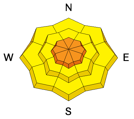
The primary avalanche concern for today is sluffing in the very low density snow. All aspects and elevations are suspect. Old retired UDOT forecaster Dave Medara would sometimes describe these point releases as going into "hovercraft mode" and this morning's sluffs may reach that criteria. These loose low density snow avalanches start at a point, fan out, and today will pile up deeply beneath steep, sustained terrain. Consider the terrain: they'll pile up even more deeply in abrupt terrain transitions or in steep gullies or creekbeds. HOT TIP! These sluffs may run naturally with additional snow/wind today - Remember that the most conservative terrain choices avoid being in or beneath steep slopes. At least a couple folks yesterday had to skitter out of the way of natural sluffs cascading down from above. HOT TIP #2 With snow this light, you won't need to be on very steep slopes to enjoy the powder - in fact on the steeper (more dangerous) slopes, you might be scraping down onto the old wind or sun crusts below the fluff. |
| type | aspect/elevation | characteristics |
|---|


|


|

LIKELIHOOD
 LIKELY
UNLIKELY
SIZE
 LARGE
SMALL
TREND
 INCREASING DANGER
SAME
DECREASING DANGER
|
description
|
| type | aspect/elevation | characteristics |
|---|


|


|

LIKELIHOOD
 LIKELY
UNLIKELY
SIZE
 LARGE
SMALL
TREND
 INCREASING DANGER
SAME
DECREASING DANGER
|
|
description
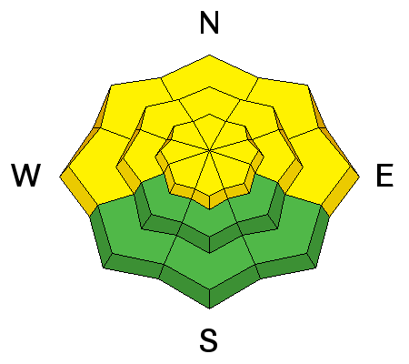
Weak surface snow (facets and patches of surface hoar), buried by myriad sun, wind, and temperature crusts lay dormant. I don't anticipate these weaknesses to be a primary player today, but if activated with enough weight (perhaps more likely with tomorrow's additional strong winds), they'll result in larger, more unmanageable avalanches. Collapsing is a sign of instability. |
 |
weather Expect another 4-8" today with generally light south-veering-to-west-to-northwest winds. They may be gusty at times along the ten and eleven thousand foot peaks. Temps will be in the teens. Another more energetic storm accompanied by strong southwest winds arrives tomorrow. |
general announcements
|