25th Annual Black Diamond Fall Fundraising Party
Thursday, September 13; 6:00-10:00 PM; Black Diamond Parking Lot
25th Annual Black Diamond Fall Fundraising Party
Thursday, September 13; 6:00-10:00 PM; Black Diamond Parking Lot
| Advisory: Provo Area Mountains | Issued by Evelyn Lees for Friday - January 13, 2017 - 6:49am |
|---|

|
bottom line The avalanche danger is CONSIDERABLE on steep wind drifted mid and upper elevation slopes where wind drifts and cornices can be easily triggered by a person. The avalanche danger is MODERATE on steep slopes at the lower elevations. The surface snow could become sensitive this afternoon if we get heating and sun. Most of the Wasatch backcountry is untracked, so start out on the lower angle slopes, and save hitting the steepest terrain for another day or two.
|
 |
current conditions Under cloudy skies, it’s a very calm morning. Temperatures are very uniform in the Provo area mountains - in the low to mid twenties. The southeasterly winds remain so very light through out the range – averaging less than 10 mph even across the highest peaks, with gusts to 15. Four-day storm totals are 3 to 5 feet in the Provo area mountains, containing 5 to 7" of water. The storm was capped off with about 7" inches of low density snow in the past 24 hours. |
 |
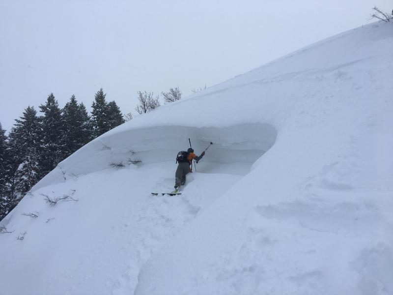
recent activity Poor visibility has kept us from observing what sort of natural avalanche cycle occurred in the Park City, Salt Lake and Provo area mountains. Avalanche reduction work at the Salt Lake and Park City resorts and for the highways yesterday triggered numerous new snow avalanches. One of the largest was a heavily wind loaded southeast facing slope on Superior, which ran to the road. Also, explosives released a 4 to 6’ deep, 80’ wide slide in graupel pooling at the below a cliff. Hopefully visibility will be better today - look for crowns and telltale signs of snow plastered on the uphill side of trees and chunks of debris. --Ogden area mountains: there was an impressive low elevation avalanche cycle Wednesday night, with slides failing on facets above Dec 16 rain crust. Check out the observations by Hardesty, Mike H and Wewer. There was also a widespread cycle in the Logan area mountains. Left: Ogden avalanche, Hardesty photo Right: Logan photo, Weed photo
|
| type | aspect/elevation | characteristics |
|---|

|
|
LIKELIHOOD
 LIKELY
UNLIKELY
SIZE
 LARGE
SMALL
TREND
 INCREASING DANGER
SAME
DECREASING DANGER
|
|
description
The wind drifts will be more stubborn to trigger today, and especially dangerous if they break above you. The drifts are most widespread on upper elevation slopes, and slopes facing northwest through southeast. Look for and avoid drifts that are cross-loaded in in open bowls, at mid slope break overs and along sub ridges. Huge cornices are still hanging along the ridgelines, and will break back much further than expected. A cornice fall could trigger a slide on the slope below. |
| type | aspect/elevation | characteristics |
|---|

|

|
LIKELIHOOD
 LIKELY
UNLIKELY
SIZE
LARGE
SMALL
TREND
INCREASING DANGER
SAME
DECREASING DANGER
|
|
description
It is still possible to trigger shallower soft slab avalanches and sluffs in steep terrain today. This afternoon, filtered sun and warming temperatures could make the new snow more sensitive. If the snow surface warms, sluffs will be easier to trigger |
| type | aspect/elevation | characteristics |
|---|

|
|
LIKELIHOOD
 LIKELY
UNLIKELY
SIZE
 LARGE
SMALL
TREND
INCREASING DANGER
SAME
DECREASING DANGER
|
|
description
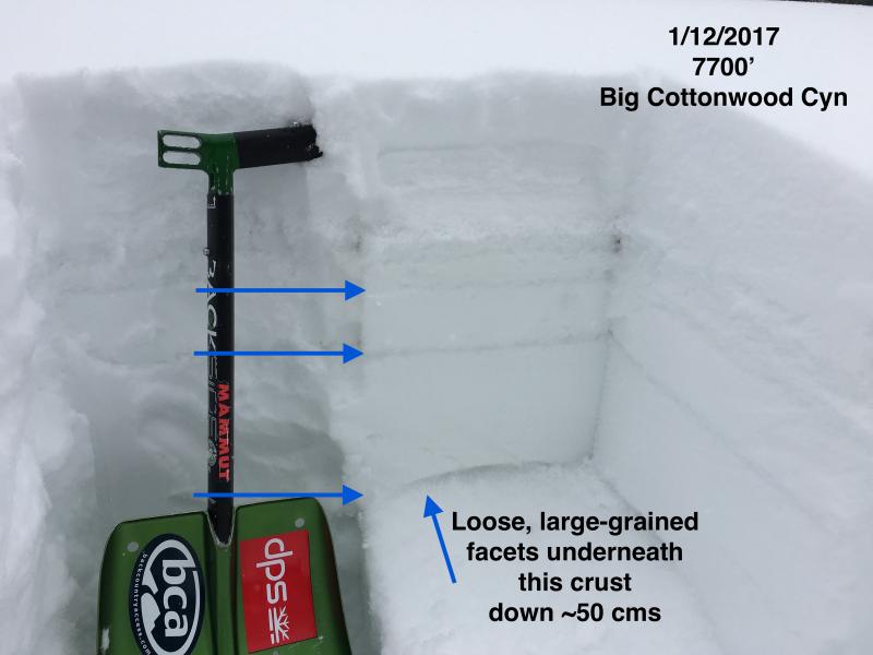
In my mind, I can just hear the snowpack groaning under the weight that has been added this month. I suspect deeper slides occurred during the storm, and in isolated places could still be triggered by a person or a smaller slide stepping down. At the mid and low elevations, there is a variable rain crust, which in places is poorly bonded to facets beneath it. Gagne observation took a look at this yesterday. Avoiding the steepest slopes at all elevations, including terrain traps like gullies and creeks banks low down, will help you avoid triggering these deeper slides. Greg Gagne photo of crusts, 7700’, Big Cottonwood
|
 |
weather After a few lingering snow showers this morning, clouds may thin this afternoon. The southeasterly winds are forecast to remain very light for the next 24 hours, averaging in the 5 to 15 mph range, even across the highest peaks. Temperatures will stay in the upper teens at 10,000’, and warm into the low 30s at 8,000’. Quiet, dry weather through the weekend will give way to another prolonged storm cycle starting mid week. |
general announcements
|