25th Annual Black Diamond Fall Fundraising Party
Thursday, September 13; 6:00-10:00 PM; Black Diamond Parking Lot
25th Annual Black Diamond Fall Fundraising Party
Thursday, September 13; 6:00-10:00 PM; Black Diamond Parking Lot
| Advisory: Provo Area Mountains | Issued by Drew Hardesty for Saturday - December 24, 2016 - 7:14am |
|---|


|
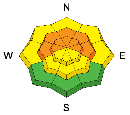
bottom line Expect the danger to rise to CONSIDERABLE in wind drifted areas. With enough snow and wind, human triggered avalanches will become probable, with natural avalanches possible. Watch for drifts in unusual locations, particularly on west to northwest facing slopes. Cracking and collapsing are sure-fire indicators of instability. Once again, the best and safest conditions will be in shady, wind sheltered locations on more gentle slopes with no overhead hazard.
|
 |
special announcement Once again this winter, our partners at the Wasatch Mountain Club are matching WMC member donations to the Utah Avalanche Center. If you are a WMC member and value avalanche forecasting and education, please send a check made out to the Utah Avalanche Center to the WMC at 1390 South 1100 East #103, Salt Lake City, UT 84105 Check out Doug Krause's podcast: Slide, the Avalanche Podcast. Highly recommended. Doug's been an avalanche professional around the globe and has a new episode out each week. You can find it on iTunes, Soundcloud, or Facebook. UDOT's draft backcountry closure policy can be found here and they will welcome comments through January 6th. |
 |
current conditions Snow totals thus far are roughly 2" as of 5am. Mountain temperatures are in the upper 20s at the trailheads and the upper teens along the higher peaks and ridgelines. The southerly winds remain in the moderate to strong category with hourly averages in the 30-40mph range with gusts to 50. Old snow surfaces prior to yesterday afternoon's light snowfall include supportable to breakable wind and sun crusts with patches of soft recrystallized powder in sheltered terrain. |
 |
recent activity None. |
| type | aspect/elevation | characteristics |
|---|

|
|
LIKELIHOOD
 LIKELY
UNLIKELY
SIZE
 LARGE
SMALL
TREND
 INCREASING DANGER
SAME
DECREASING DANGER
|
|
description
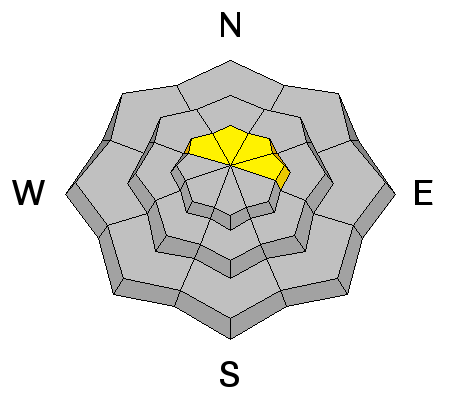
Moderate to strong and gusty southerly winds accompanying today's snowfall will provide text-book wind slabs in steep drifted terrain. In many cases, the new snow will have bonded poorly to the patchwork of old snow surfaces but it may all be a moot point with today's forecasted weather. What isn't text-book however, will be the loading zones: these southerly winds will have a touch of an easterly component to them. Don't be surprised to see drifts on unusual aspects and elevations, particularly west to northwest aspects, with drifts cross-loaded at the mid-elevations and well off the ridgelines. Test slopes should provide reliable information regarding sensitivity of the new snow. Cracking and collapsing are sure-fire indicators of instability. It may also be possible to trigger wind drifts at a distance today during periods of heavy snowfall and drifting. |
| type | aspect/elevation | characteristics |
|---|

|
|
LIKELIHOOD
 LIKELY
UNLIKELY
SIZE
 LARGE
SMALL
TREND
INCREASING DANGER
SAME
DECREASING DANGER
|
|
description
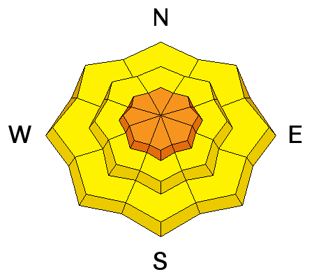
While most of today and tomorrow's activity will be "new-snow only" avalanches, with enough snow and wind it may be possible to activate a couple of the mid-pack weaknesses one to two feet down...with a remote chance of stepping down all the way to the ground interface in very isolated terrain (very steep rocky northerly terrain). |
| type | aspect/elevation | characteristics |
|---|

|
|
LIKELIHOOD
LIKELY
UNLIKELY
SIZE
LARGE
SMALL
TREND
INCREASING DANGER
SAME
DECREASING DANGER
|
|
description
For today and tomorrow: I have a great deal of uncertainty about how this storm may play out, but if forecasted snow totals verify, natural and human triggered sluffing will be certain on the steepest slopes with storm slab avalanches on many aspects and elevations. Watch for sensitivity to spike during periods of intense snowfall. |
 |
weather Snowfall - heavy at times - should continue through Christmas Day with the potential for up to 2' in favored locations. Sundance, the south end of the Park City ridgeline, upper Big Cottonwood and the Ogden area mountains should be the bread-winners today, with Little Cottonwood and the north end of the PC ridge catching up tomorrow as the flow shifts to the west and northwest. Southerly winds should be strong throughout the day with gusts reaching to 60 and 70mph. Temps will be stay in the upper 20s up high until colder air arrives tomorrow morning. |
| general announcements Remember your information can save lives. If you see anything we should know about, please help us out by submitting snow and avalanche conditions. You can also call us at 801-524-5304, email by clicking HERE, or include #utavy in your tweet or Instagram. To get help in an emergency (to request a rescue) in the Wasatch, call 911. Be prepared to give your GPS coordinates or the run name. Dispatchers have a copy of the Wasatch Backcountry Ski map. Backcountry Emergencies. It outlines your step-by-step method in the event of a winter backcountry incident. If you trigger an avalanche in the backcountry, but no one is hurt and you do not need assistance, please notify the nearest ski area dispatch to avoid a needless response by rescue teams. Thanks.
EMAIL ADVISORY If you would like to get the daily advisory by email you will need to subscribe here. DAWN PATROL Hotline updated daily by 5-530am - 888-999-4019 option 8. TWITTER Updates for your mobile phone - DETAILS UDOT canyon closures: LINK TO UDOT, or on Twitter, follow @UDOTavy, @CanyonAlerts or @AltaCentral Utah Avalanche Center mobile app - Get your advisory on your iPhone along with great navigation and rescue tools. Powderbird Helicopter Skiing - Blog/itinerary for the day Lost or Found something in the backcountry? - http://nolofo.com/ To those skinning uphill at resorts: it is critical to know the resort policy on uphill travel. You can see the uphill travel policy for each resort here. Benefit the Utah Avalanche Center when you shop from Backcountry.com or REI: Click this link for Backcountry.com or this link to REI, shop, and they will donate a percent of your purchase price to the UAC. Both offer free shipping (with some conditions) so this costs you nothing! Benefit the Utah Avalanche Center when you buy or sell on ebay - set the Utah Avalanche Center as a favorite non-profit in your ebay account here and click on ebay gives when you buy or sell. You can choose to have your seller fees donated to the UAC, which doesn't cost you a penny. This information does not apply to developed ski areas or highways where avalanche control is normally done. This advisory is from the U.S.D.A. Forest Service, which is solely responsible for its content. This advisory describes general avalanche conditions and local variations always exist. |


